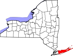
Old Field, New York | |
---|---|
Incorporated Village of Old Field | |
Coordinates: 40°57′45″N73°7′49″W / 40.96250°N 73.13028°W | |
Country | United States |
State | New York |
County | Suffolk |
Town | Brookhaven |
Incorporated | 1927 [1] |
Government | |
• Mayor | Tom Pirro |
Area | |
• Total | 2.19 sq mi (5.67 km2) |
• Land | 2.07 sq mi (5.36 km2) |
• Water | 0.12 sq mi (0.31 km2) |
Elevation | 7 ft (2 m) |
Population (2020) | |
• Total | 893 |
• Density | 431.40/sq mi (166.59/km2) |
Time zone | UTC−05:00 (Eastern Time Zone) |
• Summer (DST) | UTC−04:00 |
ZIP Code | 11733 |
Area code(s) | 631, 934 |
FIPS code | 36-54617 |
GNIS feature ID | 0959276 |
Website | www |
Old Field is a village located in the Town of Brookhaven in Suffolk County, on Long Island, in New York, United States. The population was 918 at the 2010 census. [3]
The village incorporated in 1927. [4] The Old Field Point Light located on the northern tip of Old Field, dates back to 1823. [5] It was built by the United States government for $2,500. The rest of the lighthouse was finished in 1824 for an additional $1,500. [5] The lighthouse and adjacent Keeper's Cottage serve as the Old Field Village Hall complex. [6]
According to the United States Census Bureau, the village has a total area of 2.2 square miles (5.7 km2), of which 2.1 square miles (5.4 km2) is land and 0.1 square miles (0.26 km2) is water. [7]
The tidal estuary Flax Pond is located along the northern shore of the village. [8]
Census | Pop. | Note | %± |
---|---|---|---|
1930 | 202 | — | |
1940 | 123 | −39.1% | |
1950 | 238 | 93.5% | |
1960 | 373 | 56.7% | |
1970 | 812 | 117.7% | |
1980 | 829 | 2.1% | |
1990 | 765 | −7.7% | |
2000 | 947 | 23.8% | |
2010 | 918 | −3.1% | |
2020 | 893 | −2.7% | |
U.S. Decennial Census [9] |
As of the census [10] of 2000, there were 947 people, 313 households, and 268 families residing in the village. The population density was 459.1 inhabitants per square mile (177.3/km2). There were 346 housing units at an average density of 167.7 per square mile (64.7/km2). The racial makeup of the village was 94.61% White, 0.74% African American, 0.11% Native American, 3.59% Asian, 0.42% from other races, and 0.53% from two or more races. Hispanic or Latino of any race were 2.32% of the population.
There were 313 households, out of which 42.5% had children under the age of 18 living with them, 80.2% were married couples living together, 4.5% had a female householder with no husband present, and 14.1% were non-families. 10.5% of all households were made up of individuals, and 4.8% had someone living alone who was 65 years of age or older. The average household size was 3.03 and the average family size was 3.23.
In the village, the population was spread out, with 30.0% under the age of 18, 4.6% from 18 to 24, 20.9% from 25 to 44, 32.1% from 45 to 64, and 12.4% who were 65 years of age or older. The median age was 42 years. For every 100 females, there were 98.9 males. For every 100 females age 18 and over, there were 98.5 males.
The median income for a household in the village was $165,398, and the median income for a family was $202,071. Males had a median income of $100,000 versus $33,594 for females. The per capita income for the village was $73,658. About 2.8% of families and 7.4% of the population were below the poverty threshold, including 9.5% of those under age 18 and none of those age 65 or over.
The current mayor of Old Field is Tom Gulbransen, the Deputy Mayor is William Schaefer, and the Village Trustees are Rebecca Van Der Bogart, Morgan Morrison and Hannah Smith. [11]
Cutler is a town in Washington County, Maine, United States. The town was named after Joseph Cutler, an early settler, who hailed from Newburyport, Massachusetts. The population was 524 at the 2020 census.
The village of Pocasset is a census-designated place (CDP) in the town of Bourne in Barnstable County, Massachusetts, United States, located on Buzzards Bay. The population was 2,851 at the 2010 census.
Lake Erie Beach is a hamlet and census-designated place (CDP) in the town of Evans, Erie County, New York, United States. The population was 3,872 at the 2010 census. It is part of the Buffalo–Niagara Falls Metropolitan Statistical Area.
Eaton is a town in Madison County, New York, United States. The population was 4,284 at the 2020 census.
Wampsville is a village located inside the Town of Lenox in Madison County, New York, United States. The population was 543 as of the 2010 census. It is the county seat of Madison County.
Lattingtown is a village located within the Town of Oyster Bay in Nassau County, on Long Island, in New York, United States. The population was 1,881 at the 2020 census.
Richland is a town in the northeastern part of Oswego County, New York, United States. The population was 5,718 at the 2010 census.
Sodus Point is a village in Wayne County, New York, United States. The population was 900 at the 2010 census. However, the last official US Census in 2020 recorded the population at 822. The name is derived from a nearby body of water, Sodus Bay. It is considered to be within the larger Rochester metropolitan area.
Lockbourne is a village in Franklin County and Pickaway County, Ohio, United States. The population was 236 at the 2020 census. Lockbourne is located near Rickenbacker International Airport, and had initially provided its original name of Lockbourne Air Force Base.
Newtown is a village in southeastern Hamilton County, Ohio, United States, near Cincinnati. The population was 2,702 at the 2020 census. Newtown was settled in 1792 and incorporated as a village in 1901.
Rio is a village in Columbia County, Wisconsin, United States. The population was 1,133 at the 2022 United States Census. It is part of the Madison Metropolitan Statistical Area. The village rests primarily in the town of Otsego. The Village of Rio calls itself "Camper Country USA" due to several campgrounds located near the village. Rio is halfway between Columbus and Portage on Highway 16.
Colonie is a village in Albany County, New York, United States. The population was 7,793 at the 2010 census.
Randolph is a hamlet, census-designated place (CDP) and former village in Cattaraugus County, New York, United States. It is located within the town of Randolph. The population of the village was 1,286 at the 2010 census, out of 2,602 in the town as a whole. Randolph borders the community of East Randolph.
Cato is a village in Cayuga County, New York, United States. The population was 532 at the 2010 census. The name was assigned by the surveyors of the Military Tract, and is one of many towns and villages bearing classical place names. The village of Cato is half within the town of Cato and half within the town of Ira. It is west of Syracuse.
Afton is a village in Chenango County, New York, United States. The population was 822 at the 2010 census. The village is named after the poem "Sweet Afton" by Scottish poet Robert Burns, referring to the River Afton in Ayrshire, Scotland.
Herkimer is a town in Herkimer County, New York, United States, southeast of Utica. It is named after Nicholas Herkimer. The population was 9,566 at the 2020 census, down from 10,175 in 2010.
Cape Vincent is a town in Jefferson County, New York, United States. The population was 2,765 at the 2020 census.
Philadelphia is a village in Jefferson County, New York, United States. The population was 1,252 at the 2010 census, down from 1,519 in 2000.
Bridgewater is a hamlet in Oneida County, New York, United States. The population was 470 at the 2010 census.
Parish is a town in Oswego County, New York, United States. The population was 2,558 at the 2010 census.