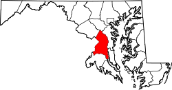
Oxon Hill-Glassmanor, Maryland

Last updated
Oxon Hill-Glassmanor, Maryland
Former CDP
Prince George's County Maryland Incorporated and Unincorporated areas Oxon Hill-Glassmanor Highlighted.svg
Location of Oxon Hill-Glassmanor, Maryland
Coordinates: 38°48′9″N76°58′32″W / 38.80250°N 76.97556°W / 38.80250; -76.97556 Coordinates: 38°48′9″N76°58′32″W / 38.80250°N 76.97556°W / 38.80250; -76.97556
CountryFlag of the United States.svg  United States
State Flag of Maryland.svg  Maryland
County Flag of Prince George's County, Maryland (1963-present).svg Prince George's
Area
  Total9.0 sq mi (23.4 km2)
  Land9.0 sq mi (23.4 km2)
  Water0.0 sq mi (0.0 km2)
Population
 (2000)
  Total35,355
  Density3,911.9/sq mi (1,510.4/km2)
Time zone UTC−5 (Eastern (EST))
  Summer (DST) UTC−4 (EDT)
FIPS code 24-59505

Oxon Hill-Glassmanor was a census-designated place (CDP) in Prince George's County, Maryland, for the 1990 and 2000 censuses. The combination is arbitrary, and in the mind of most local people there are two separate communities: Oxon Hill and Glassmanor. As of the 2010 census, Oxon Hill, National Harbor [1] and Glassmanor were delineated as separate CDPs.

Contents

History of Oxon Hill

Oxon Hill was named for the 18th Century manor home of Thomas Addison (which burned in 1895 but was replaced by another large Georgian-style home called "Oxon Hill Manor," now publicly owned, which has a river view). The community is bisected by the Capital Beltway (I-95/495) and is near the interstate Woodrow Wilson Bridge, whose gridlocked traffic (300,000 vehicles daily) backs-up daily into Oxon Hill until the wider replacement bridge is fully completed in 2008, bringing relief. (Thousands of white-collar commuters working in Northern Virginia's booming economy find that housing is cheaper in Prince George's County.)

Oxon Hill includes many garden apartment communities along with single-family detached homes dating mostly from the 1940s through the 1980s, including the incorporated town Forest Heights. In earlier decades, many residents were scientists from the adjacent U.S. Naval Research Laboratory, but very few are now. Oxon Hill's two principal shopping centers ("Rivertowne" and the much older "Eastover") attract neighborhood customers as well as shoppers from nearby Southeast Washington. Eastover, located at the D.C. state line, is a hub of many bus routes, some of them operating 24 hours a day, and has a Prince George's County Police station.

Geography

Oxon Hill-Glassmanor is located at 38°48′9″N76°58′32″W / 38.80250°N 76.97556°W / 38.80250; -76.97556 (38.802513, 76.975538). [2]

According to the United States Census Bureau, the place had a total area of 9.0 square miles (23 km2), all of it land.

Demographics

Historical population
CensusPop.
1990 35,794
2000 35,355−1.2%
source: [3]

As of the census [4] of 2000, there were 35,355 people, 13,700 households, and 9,069 families residing in the area. The population density was 3,911.9 inhabitants per square mile (1,510.4/km2). There were 14,669 housing units at an average density of 1,623.1 per square mile (626.7/km2). The racial makeup of the area was 7.64% White, 86.68% African American, 0.32% Native American, 2.78% Asian, 0.08% Pacific Islander, 0.69% from other races, and 1.80% from two or more races. Hispanic or Latino of any race were 1.68% of the population.

There were 13,700 households, out of which 35.1% had children under the age of 18 living with them, 33.2% were married couples living together, 27.1% had a female householder with no husband present, and 33.8% were non-families. 28.0% of all households were made up of individuals, and 4.1% had someone living alone who was 65 years of age or older. The average household size was 2.58 and the average family size was 3.14.

In the area the population was spread out, with 28.5% under the age of 18, 9.3% from 18 to 24, 32.8% from 25 to 44, 22.8% from 45 to 64, and 6.5% who were 65 years of age or older. The median age was 32 years. For every 100 females, there were 84.3 males. For every 100 females age 18 and over, there were 76.9 males.

The median income for a household in the area was $46,483, and the median income for a family was $52,227. Males had a median income of $35,338 versus $34,646 for females. The per capita income for the area was $21,511. About 6.7% of families and 8.8% of the population were below the poverty line, including 12.3% of those under age 18 and 8.2% of those age 65 or over.

Related Research Articles

<span class="mw-page-title-main">Tusayan, Arizona</span> Community in Coconino County, Arizona

Tusayan is a town, but was a census-designated place during the 2010 census. It is located in Coconino County, Arizona, United States. It was incorporated in 2010. A resort town near the south entrance to Grand Canyon National Park, Tusayan is served by Grand Canyon National Park Airport. The population was 558 at the 2010 census.

<span class="mw-page-title-main">Valencia West, Arizona</span> CDP in Pima County, Arizona

Valencia West is a census-designated place (CDP) in Pima County, Arizona, United States. The population was 9,355 at the 2010 census, a 293% increase over the population of 2,380 in 2000.

<span class="mw-page-title-main">Dunkirk, Maryland</span> Census-designated place in Maryland, United States

Dunkirk is a census-designated place (CDP) in Calvert County, Maryland, United States. The population was 2,521 at the 2010 census.

<span class="mw-page-title-main">Camp Springs, Maryland</span> Census-designated place in Maryland

Camp Springs is an unincorporated area and census-designated place (CDP) in Prince George's County, Maryland, United States. The population was 22,734 at the 2020 census. Camp Springs is not an official post office designation; the area is divided among the surrounding mailing addresses of Temple Hills, Fort Washington, Clinton, and Suitland.

<span class="mw-page-title-main">Coral Hills, Maryland</span> Census-designated place in Maryland

Coral Hills is an unincorporated area and census-designated place (CDP) in Prince George's County, Maryland, United States. As of the 2020 census, the population was 9,997.

<span class="mw-page-title-main">Forest Heights, Maryland</span> Town in Maryland

Forest Heights is a town in Prince George's County, Maryland, United States, and is part of the larger postal designation of Oxon Hill. The town straddles both sides of dual-lane Maryland Route 210 and includes two elementary schools. Per the 2020 census, the population was 2,658.

<span class="mw-page-title-main">Hillcrest Heights, Maryland</span> CDP in Maryland

Hillcrest Heights is an unincorporated area and census-designated place (CDP) in Prince George's County, Maryland, United States. The population was 15,793 at the 2020 census. For mailing address purposes, it is part of the smaller community of Temple Hills and is also near Suitland.

<span class="mw-page-title-main">Marlow Heights, Maryland</span> Census-designated place in Maryland

Marlow Heights is an unincorporated area and census-designated place (CDP) in Prince George's County, Maryland, United States. The population was 6,169 at the 2020 census. The Marlow Heights Shopping Center first opened in 1957, adjacent to the large community of Hillcrest Heights. It was joined ten years later, in 1967, by the two-level Iverson Mall, the Washington metropolitan area's first enclosed mall.

<span class="mw-page-title-main">Morningside, Maryland</span> Town in Maryland

Morningside is an incorporated town in Prince George's County, Maryland, United States. Per the 2020 census, the population was 1,240. The town developed with the establishment of nearby Andrews Air Force Base and the federal Census Bureau. The government of the town is led by a mayor and town council. Morningside Elementary School and Benjamin Foulois Junior High School/Elementary/Creative and Performing Arts Academy (current) as well as Michael J Polley Neighborhood Park are located within the town limits. Morningside has one of the largest VFW posts (chapters) in the entire country. Morningside is also the city of license of one of Washington's most prominent radio stations, from the 1960s to the present, WJFK and WPGC-FM. Additionally, Morningside is home to one of the busiest volunteer fire departments in Prince George's County, Morningside VFD Station 827. In 2015, station 827 ran over 8,000 calls for service with 150 working fires in Morningside and the adjacent communities, and has garnered national recognition for their service to the community.

<span class="mw-page-title-main">Rosaryville, Maryland</span> Census-designated place in Maryland

Rosaryville is an unincorporated area and census-designated place (CDP) in Prince George's County, Maryland, United States, located south of Cinton and Upper Marlboro beside U.S. Route 301. Per the 2020 census, the population was 11,548. including housing developments and rural open space. It was named for a local Roman Catholic church. Close to Rosaryville are the Marlton housing development, Maryland Veterans Cemetery, the Southern Maryland Farmers Market, and Rosaryville State Park.

<span class="mw-page-title-main">Springdale, Maryland</span> Census-designated place in Maryland

Springdale is an unincorporated area and census-designated place (CDP) in Prince George's County, Maryland, United States. Per the 2020 census, the population was 5,301.

<span class="mw-page-title-main">Suitland-Silver Hill, Maryland</span> Former census-designated place in Maryland

Suitland-Silver Hill was a census-designated place (CDP) in Prince George's County, Maryland, United States, for the 2000 U.S. Census. The census area included the separate unincorporated communities of Silver Hill and Suitland, and other smaller communities. The population was 33,515 at the 2000 census. For the 2010 census, the CDP was separated into Silver Hill and Suitland. The community was named for a 19th-century landowner, State Senator Samuel Taylor Suit and his estate.

<span class="mw-page-title-main">Temple Hills, Maryland</span> Census-designated place in Maryland

Temple Hills is an unincorporated area and census-designated place (CDP) in Prince George's County, Maryland, United States. Temple Hills borders the communities of Hillcrest Heights, Marlow Heights, Camp Springs and Oxon Hill. Per the 2020 census, the population was 8,350.

<span class="mw-page-title-main">West Laurel, Maryland</span> Census-designated place in Maryland

West Laurel is an unincorporated area and census-designated place (CDP) in Prince George's County, Maryland, United States. Per the 2020 census, the population was 4,428.

<span class="mw-page-title-main">South New Castle, Pennsylvania</span> Borough in Pennsylvania, United States

South New Castle is a borough in Lawrence County, Pennsylvania, United States. The population was 649 at the 2020 census. It is primarily a residential community which lies south of the city of New Castle, and is part of the New Castle micropolitan area.

<span class="mw-page-title-main">Donaldson, Pennsylvania</span> CDP in Pennsylvania, United States

Donaldson is a census-designated place (CDP) in Frailey Township, Schuylkill County, Pennsylvania, United States. The population was 325 at the 2000 census.

Newtown is a census-designated place (CDP) in Reilly Township, Schuylkill County in the U.S. state of Pennsylvania. The population was 244 at the 2000 census.

<span class="mw-page-title-main">Valley View, Schuylkill County, Pennsylvania</span> CDP in Pennsylvania, United States

Valley View is a census-designated place (CDP) in Schuylkill County, Pennsylvania, United States. The population was 1,677 at the 2000 census.

<span class="mw-page-title-main">Scituate (CDP), Massachusetts</span> Census-designated place in Massachusetts, United States

Scituate is a census-designated place (CDP) in the town of Scituate in Plymouth County, Massachusetts, United States. The population was 5,245 at the 2010 census.

Glassmanor is an unincorporated community and census-designated place in Prince George's County, Maryland, United States. As of the 2020 census, it had a population of 18,430. In the 1990 and 2000 censuses, the United States Census Bureau had placed Glassmanor and the adjacent community of Oxon Hill in the "Oxon Hill-Glassmanor" census-designated place for statistical purposes. Glassmanor was last delineated separately in 1980, when the CDP recorded a population of 7,751.

References

  1. U.S. Geological Survey Geographic Names Information System: National Harbor, Michigan
  2. "US Gazetteer files: 2010, 2000, and 1990". United States Census Bureau. 2011-02-12. Retrieved 2011-04-23.
  3. "CENSUS OF POPULATION AND HOUSING (1790-2000)". U.S. Census Bureau . Retrieved 2010-07-18.
  4. "U.S. Census website". United States Census Bureau . Retrieved 2008-01-31.