Salvage, Newfoundland and Labrador

Last updated

Salvage
Town
Salvage, Newfoundland and Labrador.jpg
Country Flag of Canada (Pantone).svg  Canada
Province Flag of Newfoundland and Labrador.svg  Newfoundland and Labrador
Population
 (2021) [1]
  Total108
Time zone UTC-3:30 (Newfoundland Time)
  Summer (DST) UTC-2:30 (Newfoundland Daylight)
Area code 709
Highways NL Route 310.svg Route 310

Salvage is a town located on the Eastport Peninsula of the Canadian province of Newfoundland and Labrador. The town had a population of 108 in the Canada 2021 Census. [1]

Contents

CBC Radio host Michael Enright (The Sunday Edition) calls the 9 kilometres (5.6 mi) walk from Salvage to Eastport the most beautiful in the world. [2]

History

Historically and archaeologically, the Eastport Peninsula has been host to human settlements and activity for at least 5000 years by a variety of Indigenous cultural groups, including the Maritime Archaic, the later Groswater and Dorset, and most recently Beothuk peoples. [3] [4]

The name ‘Salvage’ is thought to have originated from the Spanish term ‘Salvaje’ meaning untamed, wild, or savage. Local pronunciation rhymes with "New Age", as in "Sal'vayge". This term was potentially used as a dated reference to the continued presence of Beothuk people in the area throughout the early contact period. An alternative theory on the origins of the name Salvage is that it made reference to its geographic location on the edge of rough waters, comparing it to the selvage, the end of cloth materials, but this theory is not as well grounded. [5]

The earliest English documents referencing the area date to the second half of the 17th century, by which time English migratory fisheries in the area were well established. [6]

There is some evidence to indicate early settlement in Salvage and its neighbouring communities as early as 1672, [7] but any settlements dating to the late 17th and early 18th centuries were impermanent. [8] The first permanent settlements on the Eastport Peninsula began to emerge in the 1780s in Salvage and Barrow Harbour, although the ancestors of present-day families did not arrive until about 1820. [7]

As the central and most substantial settlement on the peninsula, one historic account describes Salvage as a spider's body connected to smaller nearby settlements by legs. [9] Salvage today consists of two main harbours in a sheltered bay: Salvage Harbour and Bishop's Harbour. These two harbours, and other surrounding small communities were historically recorded as different towns, but are today amalgamated with Salvage. [9] Throughout the 19th century the Eastport Peninsula enjoyed a period of stable growth, with Salvage reaching its peak population of 390 residents in 1891, with an additional 201 residents in the now amalgamated Bishop's Harbour. [10]

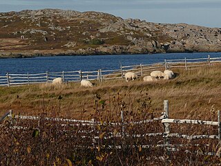
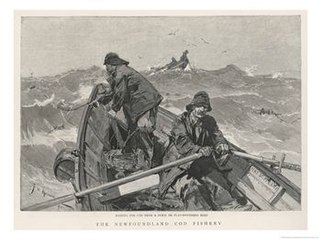
Salvage, like most other outport settlements in Newfoundland, was founded in and by the fishing industry, beginning with the seasonal fishery before transitioning into a residential fishery. Throughout the 19th century the increasing population across Newfoundland increased pressure on local fish stocks, prompting many fishermen to turn their attention towards the Labrador fishery. This fishery took place over the summer months when fishermen would take schooners up to the Labrador coast, after which they would return to their outport towns in Newfoundland to prepare and preserve their catches over the fall. In the winter months people in Salvage participated in the seal fishery, in addition to logging work and boat construction. [7]

Despite its apparent isolation as an outport settlement, people in Salvage were relatively well connected with the rest of Newfoundland for much of the 19th century by the migratory fishery. With the rise of residential fishing and the Labrador fishery, however, Salvage and its nearby communities lost a great deal of its regular seasonal visits from outside fishermen. [7]

Without major roads or telegram lines installed, as Salvage and its neighbouring communities grew so did its need for communications and travel infrastructure to connect it with the rest of Newfoundland. Far from doing nothing about this, discussion for a telegraph line to be installed to better connect the Eastport to the rest of Newfoundland in the House of Assembly in 1907 reflected the community's desire for greater access to the political scene. [11] Infrastructural projects throughout the 20th century, such as the nearby Trans-Canada Highway and Terra Nova National Park, helped mitigate this isolation and brought about a revitalised tourism industry to Salvage and neighbouring communities. [7] [6]

Throughout the 20th century Salvage, like many other remote Newfoundland communities, began to experience a decline in population in response to the decline of the Newfoundland fishery. By 1935, Salvage's population had declined to only 192, and Bishop's Harbour to 81, for a total population of 273. [12]

A fishing community, Salvage had a fish processing plant which was destroyed by fire in 2001. [13] [14] A new plant was built and operated from 2002 to 2012. [15] [16]

Demographics

In the 2021 Census of Population conducted by Statistics Canada, Salvage had a population of 108 living in 50 of its 100 total private dwellings, a change of

See also

Related Research Articles

<span class="mw-page-title-main">Fogo Island (Newfoundland and Labrador)</span> Island of Newfoundland and Labrador, Canada

Fogo Island is the largest of the offshore islands of Newfoundland and Labrador, Canada. The Town of Fogo Island encompasses Fogo, Joe Batt's Arm-Barr'd Islands-Shoal Bay, Seldom-Little Seldom and Tilting, with the unincorporated areas of Fogo Island. It lies off the northeast coast of Newfoundland, northwest of Musgrave Harbour across Hamilton Sound, just east of the Change Islands. The island is about 25 km (16 mi) long and 14 km (8.7 mi) wide. The total area is 237.71 km2 (91.78 sq mi).

<span class="mw-page-title-main">Newfoundland outport</span> Style of community

An outport is the term given for a small coastal community in the Canadian province of Newfoundland and Labrador other than the chief port of St. John's. Originally, the term was used for coastal communities on the island of Newfoundland, but the term has now been adopted for those on the mainland area of Labrador as well.

<span class="mw-page-title-main">Twillingate</span> Place in Newfoundland and Labrador, Canada

Twillingate is a town of 2,121 people located on the Twillingate Islands ("Toulinquet") in Notre Dame Bay, off the north eastern shore of the island of Newfoundland in the province of Newfoundland and Labrador, Canada. The town is about 100 kilometres (62 mi) north of Lewisporte and Gander.

<span class="mw-page-title-main">Placentia, Newfoundland and Labrador</span> Town in Newfoundland and Labrador, Canada

Placentia is a town located in the Canadian province of Newfoundland and Labrador. It consists of the Argentia Industrial Park and amalgamated communities of Townside, Freshwater, Dunville, Southeast, Point Verde and Jerseyside.

<span class="mw-page-title-main">Port Union, Newfoundland and Labrador</span> Settlement in Newfoundland and Labrador, Canada

Port Union is a historical community overlooking Trinity Bay and Catalina Harbour, on the east side of the Bonavista Peninsula, Newfoundland and Labrador, Canada.

<span class="mw-page-title-main">Eastport, Newfoundland and Labrador</span> Town in Newfoundland and Labrador, Canada

Eastport is a long-popular Newfoundland vacation destination on the Eastport Peninsula. Eastport is located on the north-eastern border of Terra Nova National Park and is known for its sandy beaches, scenery and traditional Newfoundland outport heritage.

<span class="mw-page-title-main">Tilting, Newfoundland and Labrador</span> Community in Newfoundland and Labrador, Canada

Tilting is a community on the eastern end of Fogo Island off the northeast coast of Newfoundland. It was incorporated as a town before becoming part of the Town of Fogo Island through an amalgamation in 2011. The community has been designated as a National Historic Site of Canada, and has also been designated as a Registered Heritage District by the Heritage Foundation of Newfoundland and Labrador.

The Burin Peninsula is a peninsula located on the south coast of the island of Newfoundland in the province of Newfoundland and Labrador. Marystown is the largest population centre on the peninsula.

<span class="mw-page-title-main">Harbour Breton</span> Town in Newfoundland and Labrador, Canada

Harbour Breton is a small fishing community on the Connaigre Peninsula in Fortune Bay, on the south coast of the island of Newfoundland in Canada. It is the largest center on the Connaigre Peninsula and was long considered the unofficial capital of Fortune Bay. During the 1960s many communities were resettled into Harbour Breton. Harbour Breton is the only administrative centre in Fortune Bay and is located approximately 220 kilometres (140 mi) south of Grand Falls-Windsor.

<span class="mw-page-title-main">Gaultois</span> Town in Newfoundland and Labrador, Canada

Gaultois is a small settlement in the Coast of Bays area in Newfoundland and Labrador, Canada. Gaultois had a population of 100 people in the 2021 census. The town has a K-12 school called Victoria Academy, as well as a fire department, public library, Lion's Club, and town hall. The town is only accessible by ferry or helicopter. The provincial government ferry runs from the nearby town of Hermitage several times daily and the crossing takes approximately 20 minutes. This ferry also services the more remote community of McCallum once to twice daily with a crossing time of around one hour and fifteen minutes. In 2015, Gaultois voted against resettlement. Gaultois considered resettlement again in 2023 but it failed.

<span class="mw-page-title-main">Rose Blanche-Harbour le Cou</span> Town in Newfoundland and Labrador, Canada

Rose Blanche – Harbour le Cou is a small town on Newfoundland's southwest shore, about 45 km at the end of Route 470 from Port aux Basques. This community is located in a barren area on the east side of a small bay. In this bay there are 2 harbours that were mainly used to provide shelter for fishing vessels. Scenery includes the rugged granite coastline, and the white and rocky cliffs of "Diamond Cove". Its granite lighthouse was in operation from 1873 to the 1940s. After it was abandoned in the 1940s the building fell into ruins. The spiral stone staircase extends into the tower wall and kept the tower from collapsing while the remainder of the lighthouse fell to ruin. In 1999 the lighthouse was fully reconstructed and serves as a tourist attraction.

<span class="mw-page-title-main">Lumsden, Newfoundland and Labrador</span> Town in Newfoundland and Labrador, Canada

Lumsden, formerly known as Cat Harbour, is a community located on the Straight Shore of Newfoundland in Newfoundland and Labrador, Canada, near communities such as Musgrave Harbour and Newtown. Lumsden formerly consisted of two settlements, Lumsden North on the tip of a sandy peninsula and Lumsden South on the main road. Although the harbour in Lumsden is not ideal because it is not sheltered, Lumsden has excellent fishing grounds.

<span class="mw-page-title-main">English Harbour East</span> Town in Newfoundland and Labrador, Canada

English Harbour East is a town in the Canadian province of Newfoundland and Labrador. It is located on the northeast side of Fortune Bay. Settled first by the Mi’kmaq of Newfoundland which used land on the "Neck" of the Harbour, they were joined in the early 1800s, by the English Dodge family and by Irishman Thomas Hynes Sr. European fishermen were first brought to the small community by English merchant family of Newman and Co. based in Harbour Breton, the firm of merchant John Gorman, and the Jersey firm of Nicholle and Co. The town had a population of 117 in the Canada 2021 Census.

<span class="mw-page-title-main">Cod fishing in Newfoundland</span>

Cod fishing in Newfoundland was carried out at a subsistence level for centuries, but large scale fishing began shortly after the European arrival in the North American continent in 1492, with the waters being found to be preternaturally plentiful, and ended after intense overfishing with the collapse of the fisheries in 1992.

<span class="mw-page-title-main">Resettlement (Newfoundland)</span>

Resettlement in Newfoundland and Labrador terms refers to an organized approach to centralize the population into growth areas. It is used in the current context when referring to a voluntary relocation initiated from isolated communities themselves.

<span class="mw-page-title-main">South East Bight</span> Local service district / designated place in Newfoundland and Labrador, Canada

South East Bight (SEB) or Southeast Bight is a local service district and designated place in the Canadian province of Newfoundland and Labrador. It is on the western shore of Placentia Bay on the Burin Peninsula. The community is not connected by road and is only accessible by ferry from Petite Forte. Many people from the community travel to Monkstown in the winter by snowmobile, but is very uncommon to try to get there in the summer, because of marsh, bogs, ponds and hills. To get to South East Bight one must travel towards Marystown on the Burin Peninsula, turn off the highway at Boat Harbour, travel to Petite Forte and then take a half-hour ferry ride to South East Bight.

William's Harbour is a former local service district and designated place in the Canadian province of Newfoundland and Labrador. The community was entirely resettled in 2017. The settlement was part of the NunatuKavut territory.

<span class="mw-page-title-main">Newfoundland (island)</span> Island portion of Newfoundland and Labrador, Canada

Newfoundland is a large island situated off the eastern coast of the North American mainland and the most populous part of the Canadian province of Newfoundland and Labrador. The island contains 29 percent of the province's land area. The island is separated from the Labrador Peninsula by the Strait of Belle Isle and from Cape Breton Island by the Cabot Strait. It blocks the mouth of the Saint Lawrence River, creating the Gulf of Saint Lawrence, the world's largest estuary. Newfoundland's nearest neighbour is the French overseas collectivity of Saint Pierre and Miquelon.

Caplin Cove-Southport is a local service district and designated place in Trinity Bay in the Canadian province of Newfoundland and Labrador. Caplin Cove-Southport is approximately 50 km from Clarenville.

Burnside-St. Chads is a local service district and designated place on the Eastport Peninsula in the Canadian province of Newfoundland and Labrador. A port is located in Burnside through which the MV Grace Sparkes services the isolated island outport of St. Brendan's. Burnside-St. Chads community had a population of 79 in the 2021 census.

References

  1. 1 2 3 "Population and dwelling counts: Canada, provinces and territories, census divisions and census subdivisions (municipalities), Newfoundland and Labrador". Statistics Canada. February 9, 2022. Retrieved March 15, 2022.
  2. "Home | Sunday | CBC Radio".
  3. Carignan, Paul. 1977. Beothuk Archaeology in Bonavista Bay. Archaeological Survey of Canada. National Museums of Canada: Ottawa.
  4. Tuck, James A. 1976. A Newfoundland and Labrador Prehistory. Archaeological Survey of Canada. National Museums of Canada: Ottawa.
  5. "Salvage". Decks Awash. 14 (5): 16–17. 1985.
  6. 1 2 "Salvage". Maritime History Archive. Retrieved Nov 12, 2020.
  7. 1 2 3 4 5 Major, Kevin. 1983. Terra Nova National Park: Human History Study. National Historic Parks and Sites Branch Parks Canada Environment Canada: Ottawa Ontario.
  8. Handcock, W. Gordon. "Eastport Peninsula: The Treaty Shore Era".
  9. 1 2 Handcock, Gordon (2002). "Eastport Peninsula: Community Origins". Newfoundland and Labrador Heritage Website.
  10. Newfoundland Colonial Secretary’s Office. 1893. Census of Newfoundland and Labrador, 1891. J.W. Withers, Queen's Printer: St.John’s Newfoundland. p122
  11. “House of Assembly Proceedings,” St. John’s Evening Telegram (March 25, 1907).
  12. Newfoundland Department of Public Health and Welfare. 1937. Census of Newfoundland and Labrador, 1935. Volume 1. Newfoundland Department of Public Health and Welfare: St.John’s Newfoundland.
  13. "MHA comments on destruction of Salvage fish plant". Government of Newfoundland and Labrador. June 21, 2001. Retrieved Nov 5, 2020.
  14. Pickersgill, Peter (Apr 6, 2013). "How neglect of the fishery killed the Salvage fish plant". CBC News. Retrieved Nov 5, 2020.
  15. "N.L. government will help displaced fish plant workers". CBC News. Mar 7, 2013. Retrieved Nov 5, 2020.
  16. "Workers reeling from fish plant closures". CBC News. Mar 5, 2013. Retrieved Nov 5, 2020.
The harbour of Salvage NLC Eastport5 tango7174.jpg
The harbour of Salvage

48°41′13″N53°38′41″W / 48.687°N 53.6447°W / 48.687; -53.6447