Springfield is a suburb in the City of Brisbane, Queensland, Australia. In the 2021 census, Springfield had a population of 7,322 people.

Kholo is a rural locality in the City of Brisbane, Queensland, Australia. In the 2021 census, Kholo had a population of 374 people.

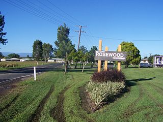
Rosewood is a rural town and locality in the City of Ipswich, Queensland, Australia. In the 2021 census, the locality of Rosewood had a population of 3,263 people.

Grandchester is a rural town and locality in the City of Ipswich, Queensland, Australia. In the 2021 census, the locality of Grandchester had a population of 467 people.

Pine Mountain is a semi-rural locality in the City of Ipswich, Queensland, Australia. In the 2021 census, Pine Mountain had a population of 1,695 people.

Springfield Lakes is a suburb in the City of Ipswich, Queensland, Australia. It is one of the suburbs created within Greater Springfield. In the 2021 census, Springfield Lakes had a population of 17,211 people.

Brookwater is a suburb in the City of Ipswich, Queensland, Australia. It is one of the suburbs of the Greater Springfield Development. In the 2021 census, Brookwater had a population of 2,902 people.

Walloon is a town and rural residential locality in the City of Ipswich, Queensland, Australia. In the 2021 census, the locality of Walloon had a population of 2,305 people.

Mount Marrow is a rural locality in the City of Ipswich, Queensland, Australia. In the 2021 census, Mount Marrow had a population of 182 people.

Ripley is a suburb in the City of Ipswich, Queensland, Australia. In the 2021 census, Ripley had a population of 4,288 people.

South Ripley is a rural locality and suburb of Ipswich in the City of Ipswich, Queensland, Australia. South Ripley is part of the Ecco Ripley urban development area. In the 2021 census, South Ripley had a population of 4,069 people.

Dugandan is a rural town and locality in the Scenic Rim Region, Queensland, Australia. In the 2021 census, the locality of Dugandan had a population of 602 people.

Mount Walker is a rural locality in the Scenic Rim Region, Queensland, Australia. In the 2021 census, Mount Walker had a population of 129 people.

Mount Forbes is a rural locality split between the City of Ipswich and the Scenic Rim Region, Queensland, Australia. In the 2021 census, Mount Forbes had a population of 262 people.

Mount Whitestone is a rural locality in the Lockyer Valley Region, Queensland, Australia. In the 2021 census, Mount Whitestone had a population of 129 people.

Lanefield is a rural locality in the City of Ipswich, Queensland, Australia. In the 2021 census, Lanefield had a population of 97 people.

Mount Mort is a rural locality in the City of Ipswich, Queensland, Australia. In the 2021 census, Mount Mort had a population of 78 people.

Coulson is a rural locality in the Scenic Rim Region, Queensland, Australia. In the 2021 census, Coulson had a population of 168 people.

College View is a rural locality in the Lockyer Valley Region, Queensland, Australia. In the 2021 census, College View had a population of 72 people.
Veradilla is a rural locality in the Lockyer Valley Region, Queensland, Australia. In the 2021 census, Veradilla had a population of 125 people.


