Sturgeon | |
---|---|
Coordinates: 47°46′36″N92°52′08″W / 47.77667°N 92.86889°W | |
Country | United States |
State | Minnesota |
County | Saint Louis |
Township | Sturgeon Township |
Elevation | 1,302 ft (397 m) |
Population | |
• Total | 30 |
Time zone | UTC-6 (Central (CST)) |
• Summer (DST) | UTC-5 (CDT) |
ZIP codes | 55703 |
Area code | 218 |
GNIS feature ID | 662575 [1] |
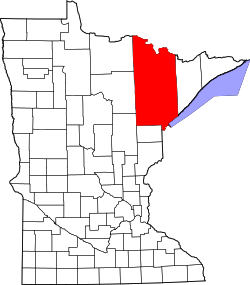
Sturgeon is an unincorporated community in Sturgeon Township, Saint Louis County, Minnesota, United States.
The community is 14 miles (23 km) southwest of Cook at the junction of State Highway 73 (MN 73) and Saint Louis County Road 22 (CR 22). It is 20 miles (32 km) north of Chisholm.
Sturgeon is near the Sturgeon River State Forest and the Superior National Forest in Saint Louis County.
St. Louis County is a county located in the Arrowhead Region of the U.S. state of Minnesota. As of the 2020 census, the population was 200,231. Its county seat is Duluth. It is the largest county in Minnesota by land area, and the largest in the United States by total area east of the Mississippi River, ahead of Aroostook County, Maine.
Alango Township is a township in Saint Louis County, Minnesota, United States. The population was 258 at the 2010 census. Saint Louis County Roads 22 and 25 are two of the main routes in the township. Heino Road and Samuelson Road also pass through the township. Cook is nearby.
Angora Township is a township in Saint Louis County, Minnesota, United States. The population was 249 at the 2010 census. Angora Township was named after Angora, in Turkey.
Balkan Township is a township in Saint Louis County, Minnesota, United States. The township was named after the Balkan Mountains. The population was 832 at the 2010 census.
Field Township is a township in Saint Louis County, Minnesota, United States. The population was 391 at the 2010 census.
Floodwood is a city in Saint Louis County, Minnesota, United States. The population was 528 at the 2010 census.
French Township is a township in Saint Louis County, Minnesota, United States. The population was 567 at the 2010 census.
Linden Grove Township is a township in Saint Louis County, Minnesota, United States. The population was 145 at the 2010 census.
Morcom Township is a township in Saint Louis County, Minnesota, United States. The population was 94 at the 2010 census.
Sturgeon Township is a township in Saint Louis County, Minnesota, United States. The population was 140 at the 2010 census.
Willow Valley Township is a township in Saint Louis County, Minnesota, United States. The population was 126 at the 2010 census.
Minnesota State Highway 73 (MN 73) is a 119.697-mile-long (192.634 km) highway in northeast Minnesota, which runs from its interchange with Interstate Highway 35 in Moose Lake and continues north to its northern terminus at its intersection with U.S. Highway 53 in Field Township near Cook and Orr.
Independence is an unincorporated community in New Independence Township, Saint Louis County, Minnesota, United States.
Linden Grove is an unincorporated community in Linden Grove Township, Saint Louis County, Minnesota, United States.
Ash Lake is an unincorporated community in Saint Louis County, Minnesota, United States; located within the Kabetogama State Forest.
Bear River is an unincorporated community in Itasca and Saint Louis counties in the U.S. state of Minnesota.
Idington is an unincorporated community in Angora Township, Saint Louis County, Minnesota, United States; located within the Sturgeon River State Forest.
The George Washington State Forest is a state forest located in Itasca, Koochiching, and Saint Louis counties, Minnesota. The forest was established and named after George Washington in 1931, the first President of the United States, to commemorate the bicentennial of his birth. The forest borders the Chippewa National Forest and completely environs the Scenic State Park to the west, and borders the Sturgeon River State Forest and McCarthy Beach State Park to the east. The Taconite State Trail passes through the forest.
The Kabetogama State Forest is a state forest located in Koochiching and Saint Louis counties, Minnesota, United States. The forest borders the Superior National Forest and the Boundary Waters Canoe Area Wilderness to the east, the Sturgeon River State Forest to the south, the Nett Lake Indian Reservation to the west, and Voyageurs National Park to the north. The forest is managed by the Minnesota Department of Natural Resources.
Gheen is an unincorporated community in Gheen Territory, Saint Louis County, Minnesota, United States, one mile (1.6 km) east of Gheen Corner on Willow River Road.