Terra Mar, Florida

Last updated
Terra Mar, Florida
neighborhood
Coordinates: 26°12′45″N80°5′44″W / 26.21250°N 80.09556°W / 26.21250; -80.09556 Coordinates: 26°12′45″N80°5′44″W / 26.21250°N 80.09556°W / 26.21250; -80.09556
Country Flag of the United States.svg  United States
State Flag of Florida.svg  Florida
County   Broward
Area
  Total 0.4 sq mi (1.0 km2)
  Land 0.4 sq mi (1.0 km2)
  Water 0.0 sq mi (0.0 km2)
Elevation 3 ft (1 m)
Population (2000)
  Total 2,631
  Density 7,054.3/sq mi (2,723.7/km2)
Time zone Eastern (EST) (UTC-5)
  Summer (DST) EDT (UTC-4)
FIPS code 12-71558 [1]
GNIS feature ID 0292133 [2]

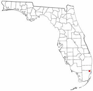
Terra Mar was a census-designated place (CDP) in Broward County, Florida, United States. The population was 2,631 at the 2000 census. Most of the neighborhood belongs to Lauderdale-by-the-Sea, Florida with a small portion belonging to Pompano Beach, Florida. [3]

A census-designated place (CDP) is a concentration of population defined by the United States Census Bureau for statistical purposes only. CDPs have been used in each decennial census since 1980 as the counterparts of incorporated places, such as self-governing cities, towns, and villages, for the purposes of gathering and correlating statistical data. CDPs are populated areas that generally include one officially designated but currently unincorporated small community, for which the CDP is named, plus surrounding inhabited countryside of varying dimensions and, occasionally, other, smaller unincorporated communities as well. CDPs include small rural communities, colonias located along the U.S. border with Mexico, and unincorporated resort and retirement communities and their environs.

Broward County, Florida County in Florida ----

Broward County is a county in the southeastern part of the U.S. state of Florida. According to a 2017 census report, the county had a population of 1,935,878, making it the second-most populous county in Florida and the 15th-most populous county in the United States. The county seat is Fort Lauderdale.

Florida State of the United States of America

Florida is the southernmost contiguous state in the United States. The state is bordered to the west by the Gulf of Mexico, to the northwest by Alabama, to the north by Georgia, to the east by the Atlantic Ocean, and to the south by the Straits of Florida. Florida is the 22nd-most extensive, the 3rd-most populous, and the 8th-most densely populated of the U.S. states. Jacksonville is the most populous municipality in the state and the largest city by area in the contiguous United States. The Miami metropolitan area is Florida's most populous urban area. Tallahassee is the state's capital.

Contents

Geography

Terra Mar is located at 26°12′45″N80°5′44″W / 26.21250°N 80.09556°W / 26.21250; -80.09556 (26.212493, -80.095452). [4]

According to the United States Census Bureau, the CDP has a total area of 1.0 km² (0.4 mi²), all land.

United States Census Bureau bureau of the United States responsible for the census and related statistics

The United States Census Bureau is a principal agency of the U.S. Federal Statistical System, responsible for producing data about the American people and economy. The Census Bureau is part of the U.S. Department of Commerce and its director is appointed by the President of the United States.

Demographics

As of the census [1] of 2000, there were 2,631 people, 1,570 households, and 766 families residing in the CDP. The population density was 2,745.5/km² (7,054.3/mi²). There were 2,712 housing units at an average density of 2,830.0/km² (7,271.4/mi²). The racial makeup of the CDP was 97.87% White (93.5% were Non-Hispanic White,) [5] 0.57% African American, 0.19% Asian, 0.57% from other races, and 0.80% from two or more races. Hispanic or Latino of any race were 5.06% of the population.

Population density A measurement of population numbers per unit area or volume

Population density is a measurement of population per unit area or unit volume; it is a quantity of type number density. It is frequently applied to living organisms, and most of the time to humans. It is a key geographical term. In simple terms population density refers to the number of people living in an area per kilometer square.

There were 1,570 households out of which 5.3% had children under the age of 18 living with them, 42.8% were married couples living together, 4.1% had a female householder with no husband present, and 51.2% were non-families. 44.6% of all households were made up of individuals and 22.5% had someone living alone who was 65 years of age or older. The average household size was 1.68 and the average family size was 2.23.

Marriage social union or legal contract between people called spouses that creates kinship

Marriage, also called matrimony or wedlock, is a socially or ritually recognised union between spouses that establishes rights and obligations between those spouses, as well as between them and any resulting biological or adopted children and affinity. The definition of marriage varies around the world not only between cultures and between religions, but also throughout the history of any given culture and religion, evolving to both expand and constrict in who and what is encompassed, but typically it is principally an institution in which interpersonal relationships, usually sexual, are acknowledged or sanctioned. In some cultures, marriage is recommended or considered to be compulsory before pursuing any sexual activity. When defined broadly, marriage is considered a cultural universal. A marriage ceremony is known as a wedding.

In the CDP, the population was spread out with 5.0% under the age of 18, 1.7% from 18 to 24, 17.3% from 25 to 44, 31.6% from 45 to 64, and 44.4% who were 65 years of age or older. The median age was 62 years. For every 100 females, there were 90.1 males. For every 100 females age 18 and over, there were 89.3 males.

The median income for a household in the CDP was $50,394, and the median income for a family was $63,625. Males had a median income of $57,171 versus $35,625 for females. The per capita income for the CDP was $40,923. About 3.6% of families and 8.2% of the population were below the poverty line, including 15.0% of those under age 18 and 7.2% of those age 65 or over.

Per capita income mean income of the people in an economic unit such as a country or city

Per capita income (PCI) or average income measures the average income earned per person in a given area in a specified year. It is calculated by dividing the area's total income by its total population.

As of 2000, English as a first language accounted for 80.88% of all residents, while both French and Spanish made up 5.83%, Italian 3.42%, German was at 3.21%, and Arabic was the mother tongue of 0.80% of the population. [6]

Related Research Articles

Franklin Park is a census-designated place (CDP) in Broward County, Florida, United States. The population was 860 at the 2010 census.

Sunshine Acres, Florida Former CDP in Florida, United States

Sunshine Acres is a former census-designated place (CDP) in Broward County, Florida, United States. The population was 827 at the 2000 census. The area is now a neighborhood within the town of Davie.

Charleston Park, Florida CDP in Florida, United States

Charleston Park is a census-designated place (CDP) in Lee County, Florida, United States. The population was 411 at the 2000 census. It is part of the Cape Coral-Fort Myers, Florida Metropolitan Statistical Area.

Suncoast Estates, Florida CDP in Florida, United States

Suncoast Estates is a census-designated place (CDP) in Lee County, Florida, United States. The population was 4,867 at the 2000 census. It is part of the Cape Coral-Fort Myers, Florida Metropolitan Statistical Area.

Lake Lucerne, Florida Neighborhood of Miami Gardens in Miami-Dade, Florida, United States

Lake Lucerne is a neighborhood in Miami Gardens, Florida, United States The population was 9,132 at the 2000 census.

Opa-locka North, Florida Neighborhood of Miami Gardens in Miami-Dade, Florida, United States

Opa-locka North is a neighborhood in Miami Gardens, Florida, United States. The population was 6,224 at the 2000 census.

Palmetto Estates, Florida CDP in Florida, United States

Palmetto Estates is a census-designated place (CDP) in Miami-Dade County, Florida, United States. The population was 13,675 at the 2000 census.

Tavernier, Florida Census-designated place & Unincorporated community in Florida, United States

Tavernier is a census-designated place (CDP) and unincorporated community in Monroe County, Florida, United States on Key Largo, the largest island in the upper Florida Keys. Tavernier's population was 2,173 at the 2000 census.

Fairview Shores, Florida Census-designated place in Florida, United States

Fairview Shores is a census-designated place and an unincorporated area in Orange County, Florida, United States. The population was 10,239 at the 2010 census. It is part of the Orlando–Kissimmee–Sanford, Florida Metropolitan Statistical Area.

Boca Del Mar, Florida unincorporated place in Florida, United States

Boca Del Mar was a census-designated place (CDP) in an unincorporated area near Boca Raton in Palm Beach County, Florida, United States. The population was 21,832 at the 2000 census. While it is not officially in the City of Boca Raton, the community is often classified under its umbrella term.

Cypress Lakes, Florida unincorporated place in Florida, United States

Cypress Lakes was a census-designated place (CDP) in Palm Beach County, Florida, United States. The population was 1,468 at the 2000 census.

Lake Harbor is a census-designated place (CDP) in Palm Beach County, Florida, United States. The population was 195 at the 2000 census. It located along the southern banks of Lake Okeechobee, at the beginning of the Miami Canal. John Stretch Park is also located alongside the north end of Lake Harbor and the lake.

Lakeside Green, Florida unincorporated place in Florida, United States

Lakeside Green was a census-designated place (CDP) in Palm Beach County, Florida, United States. The population was 3,311 at the 2000 census.

Stacy Street is a street and surrounding census-designated place (CDP) in Palm Beach County, Florida, United States. The population was 958 at the 2000 census, which misspelled it Stacey Street.

Whisper Walk, Florida unincorporated place in Florida, United States

Whisper Walk was a census-designated place (CDP) located in an unincorporated area northwest of Boca Raton in Palm Beach County, Florida, United States. The population was 5,135 at the 2000 census. While it is not in the city of Boca Raton, Boca Raton is its postal address, and the community is frequently classified under its umbrella term.

Glencoe, Florida CDP in Florida, United States

Glencoe is a census-designated place (CDP) in Volusia County, Florida, United States. The population was 2,582 at the 2010 census.

West Dennis, Massachusetts Census-designated place in Massachusetts, United States

West Dennis is a census-designated place (CDP) in the town of Dennis in Barnstable County, Massachusetts, United States. The population was 2,242 at the 2010 census.

North Pembroke, Massachusetts Census-designated place in Massachusetts, United States

North Pembroke is a census-designated place (CDP) in the town of Pembroke in Plymouth County, Massachusetts, United States. The population was 3,292 at the 2010 census.

New Falcon, Texas CDP in Texas, United States

New Falcon is a census-designated place (CDP) in Zapata County, Texas, United States. The population was 191 at the 2010 census.

Fairlea, West Virginia Census-designated place in West Virginia, United States

Fairlea is a census-designated place (CDP) in Greenbrier County, West Virginia, United States. The population was 1,747 at the 2010 census. Fairlea is the location of the annual West Virginia State Fair, held in August.

References

  1. 1 2 "American FactFinder". United States Census Bureau . Retrieved 2008-01-31.
  2. "US Board on Geographic Names". United States Geological Survey. 2007-10-25. Retrieved 2008-01-31.
  3. "Map of Terra Mar, FL". terramarisland.org. Retrieved 2007-11-18.
  4. "US Gazetteer files: 2010, 2000, and 1990". United States Census Bureau. 2011-02-12. Retrieved 2011-04-23.
  5. "Demographics of Terra Mar, FL". MuniNetGuide.com. Retrieved 2007-11-18.
  6. "MLA Data Center Results for Terra Mar, Florida". Modern Language Association . Retrieved 2007-11-18.