| The President | |
|---|---|
 | |
| Highest point | |
| Elevation | 3,123 m (10,246 ft) [1] |
| Prominence | 653 m (2,142 ft) [1] (above Kiwetinok Pass) |
| Listing | Mountains of British Columbia |
| Coordinates | 51°30′02″N116°33′42″W / 51.50056°N 116.56167°W [2] |
| Geography | |
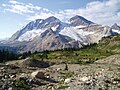
 The President Location in British Columbia | |
| Country | Canada |
| Province | British Columbia |
| District | Kootenay Land District |
| Parent range | President Range Canadian Rockies |
| Topo map | NTS 82N10 Blaeberry River [2] |
| Climbing | |
| First ascent | 1901 by James Outram, Christian Kaufmann and Joseph Pollinger [3] |
| Easiest route | scramble |
The President is a mountain peak on The President/Vice-President Massif of the President Range, in eastern British Columbia. It is just north of Emerald Lake in Yoho National Park, near the Alpine Club of Canada's Stanley Mitchell hut.