
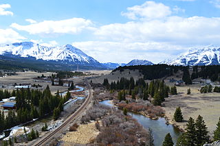
The Crowsnest Highway is an east-west highway in British Columbia and Alberta, Canada. It stretches 1,161 km (721 mi) across the southern portions of both provinces, from Hope, British Columbia to Medicine Hat, Alberta, providing the shortest highway connection between the Lower Mainland and southeast Alberta through the Canadian Rockies. Mostly two-lane, the highway was officially designated in 1932, mainly following a mid-19th-century gold rush trail originally traced out by an engineer named Edgar Dewdney. It takes its name from the Crowsnest Pass, the location at which the highway crosses the Continental Divide between British Columbia and Alberta.

Crowsnest Pass is a low mountain pass across the Continental Divide of the Canadian Rockies on the Alberta–British Columbia border.

The Municipality of Crowsnest Pass is a specialized municipality in southwest Alberta, Canada. Within the Rocky Mountains adjacent to the eponymous Crowsnest Pass, the municipality formed as a result of the 1979 amalgamation of five municipalities – the Village of Bellevue, the Town of Blairmore, the Town of Coleman, the Village of Frank, and Improvement District No. 5, which included the Hamlet of Hillcrest and numerous other unincorporated communities.
Frank is an urban community in the Rocky Mountains within the Municipality of Crowsnest Pass in southwest Alberta, Canada. It was formerly incorporated as a village prior to 1979 when it amalgamated with four other municipalities to form Crowsnest Pass.

Highway 3 is a 324-kilometre (201 mi) highway that traverses southern Alberta, Canada, running from the Crowsnest Pass through Lethbridge to the Trans-Canada Highway in Medicine Hat. Together with British Columbia Highway 3 which begins in Hope, it forms an interprovincial route that serves as an alternate to the Trans-Canada from the Lower Mainland to the Canadian Prairies.

The Purcell Mountains are a mountain range in southeastern British Columbia, Canada. They are a subrange of the Columbia Mountains, which includes the Selkirk, Monashee, and Cariboo Mountains. They are located on the west side of the Rocky Mountain Trench in the area of the Columbia Valley, and on the east side of the valley of Kootenay Lake and the Duncan River. The only large settlements in the mountains are the Panorama Ski Resort and Kicking Horse Resort, adjacent to the Columbia Valley towns of Invermere and Golden, though there are small settlements, such as Yahk and Moyie along the Crowsnest Highway, and residential rural areas dependent on the cities of Creston, Kimberley and Cranbrook, which are located adjacent to the range..
The Crowsnest River is a tributary to the Oldman River in southwestern Alberta, Canada.

The Frank Slide was a massive rockslide that buried part of the mining town of Frank in the District of Alberta of the North-West Territories, Canada, at 4:10 a.m. on April 29, 1903. Around 44 million cubic metres/110 million tonnes of limestone rock slid down Turtle Mountain. Witnesses reported that within 100 seconds the rock reached up the opposing hills, obliterating the eastern edge of Frank, the Canadian Pacific Railway (CPR) line and the coal mine. It was one of the largest landslides in Canadian history and remains the deadliest, as between 70 and 90 of the town's residents died, most of whom remain buried in the rubble. Multiple factors led to the slide: Turtle Mountain's formation left it in a constant state of instability. Coal mining operations may have weakened the mountain's internal structure, as did a wet winter and cold snap on the night of the disaster.

Alberta has been a tourist destination since the early days of the 20th Century, with attractions including national parks, National Historic Sites of Canada, urban arts and cultural facilities, outdoor locales for skiing, hiking and camping, shopping locales such as West Edmonton Mall, outdoor festivals, professional athletic events, international sporting competitions such as the Commonwealth Games and Olympic Winter Games, as well as more eclectic attractions.
Provincial historic sites of Alberta are museums and historic sites run by the Government of Alberta.
British Columbia Highway 3, officially named the Crowsnest Highway, is an 841-kilometre (523 mi) highway that traverses southern British Columbia, Canada. It runs from the Trans-Canada Highway (Highway 1) at Hope to Crowsnest Pass at the Alberta border and forms the western portion of the interprovincial Crowsnest Highway that runs from Hope to Medicine Hat, Alberta. The highway is considered a Core Route of the National Highway System.
The Energy Resources Conservation Board (ERCB) was an independent, quasi-judicial agency of the Government of Alberta. It regulated the safe, responsible, and efficient development of Alberta's energy resources: oil, natural gas, oil sands, coal, and pipelines. Led by eight Board members, the ERCB's team of engineers, geologists, technicians, economists, and other professionals served Albertans from thirteen locations across the province.
The Birch Mountains kimberlite field is a cluster of kimberlitic volcanic pipes or diatremes in north-central Alberta, Canada that were emplaced during a period of kimberlitic volcanism in the Late Cretaceous epoch. As of 2011, 8 diatremes had been discovered in the field, and diamonds and microdiamononds had been recovered during sampling programs.

Oil reserves in Canada were estimated at 172 billion barrels as of the start of 2015 . This figure includes the oil sands reserves that are estimated by government regulators to be economically producible at current prices using current technology. According to this figure, Canada's reserves are third only to Venezuela and Saudi Arabia. Over 95% of these reserves are in the oil sands deposits in the province of Alberta. Alberta contains nearly all of Canada's oil sands and much of its conventional oil reserves. The balance is concentrated in several other provinces and territories. Saskatchewan and offshore areas of Newfoundland in particular have substantial oil production and reserves. Alberta has 39% of Canada's remaining conventional oil reserves, offshore Newfoundland 28% and Saskatchewan 27%, but if oil sands are included, Alberta's share is over 98%.
The Alberta Group is a stratigraphical unit of Cenomanian to early Campanian age in the Lewis overthrust in the Western Canadian Sedimentary Basin.
The Elk Point Group is a stratigraphic unit of Early to Middle Devonian age in the Western Canada and Williston sedimentary basins. It underlies a large area that extends from the southern boundary of the Northwest Territories in Canada to North Dakota in the United States. It has been subdivided into numerous formations, number of which host major petroleum and natural gas reservoirs.

Lille is a ghost town and former village in the Crowsnest Pass area of southwest Alberta, Canada. It was a company-built coal mining community that, between 1901 and 1912, hosted a population that grew to over 400. The mines at Lille closed in 1912, due primarily to weak coal prices, increasing production costs, and the increasingly poor quality of the coal. The community was then dismantled and most of its structures were moved elsewhere. Today the site is an Alberta Provincial Historic Resource and is known for the elegant ruins of a set of Bernard-style coke ovens that was imported from Belgium.

The geology of North Dakota includes thick sequences oil and coal bearing sedimentary rocks formed in shallow seas in the Paleozoic and Mesozoic, as well as terrestrial deposits from the Cenozoic on top of ancient Precambrian crystalline basement rocks. The state has extensive oil and gas, sand and gravel, coal, groundwater and other natural resources.
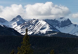
Mount McLaren is a 2,301-metre (7,549-foot) mountain summit located in Alberta, Canada.
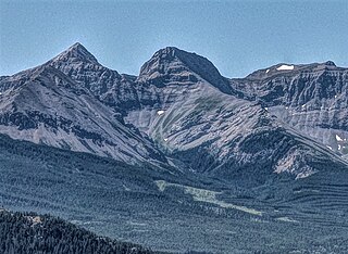
Mount Parrish is a 2,530-metre (8,301-foot) mountain summit located in Alberta, Canada.


