
Aberdeen is a town in Saskatchewan, Canada. Located 18 minutes north-east of Saskatoon, it has a population of 716 people.

Eatonia is a town in the Canadian province of Saskatchewan with a population of 449 people. The town's economy is based almost exclusively on agriculture. Eatonia is in southwest Saskatchewan at the crossroads of Highways 21 and 44, approximately 44 kilometres southwest of Kindersley and 72 kilometres from the provincial boundary with Alberta. The town is served by Eatonia Municipal Airport.
Sturgis is a town of 620 people in east-central Saskatchewan, Canada. The Town of Sturgis is 95 kilometres (59 mi) north of Yorkton on Highway 9. It is located in the Assiniboine River valley near the Lakes and Woods region of the province.

Rosetown is a town in the Canadian province of Saskatchewan, at the junction of provincial Highway 7 and Highway 4, approximately 115 kilometres southwest of Saskatoon. The town's motto, "The Heart of the Wheat Belt" reflects its history of being a farming community. It is within the Rural Municipality of St. Andrews No. 287.

Annaheim is a village in the Canadian province of Saskatchewan within the Rural Municipality of St. Peter No. 369 and Census Division No. 15. The village is located about 125 km east of the City of Saskatoon, at the junction of provincial Highway 756 and Highway 779. Annaheim hosts the offices of the Rural Municipality of St. Peter No. 369.

The Rural Municipality of Aberdeen No. 373 is a Rural Municipality (RM) in the Canadian province of Saskatchewan within Census Division No. 15 and SARM Division No. 5. It is located on the South Saskatchewan River.

Wakaw, Saskatchewan, is a town 90 kilometres (56 mi) northeast of Saskatoon and 66 kilometres (41 mi) south of Prince Albert. It is about halfway between the two cities and is served by Highway 2, Highway 41, and Highway 312. Wakaw is in hilly partially forested country east of the South Saskatchewan River. The area is part of the aspen parkland biome.

Langham is a town in Saskatchewan, Canada. It is on Highway 16, surrounded by the Rural Municipality of Corman Park No. 344, and about 35 kilometres (22 mi) northwest of the city of Saskatoon. The 2011 census reported a population of 1,290, with 489 homes in the community.

Blaine Lake is a town in central Saskatchewan, Canada. It is located 85 km north of Saskatoon, 104 km southwest of Prince Albert and 104 km east of North Battleford at the junction of Highway 12 and Highway 40. Nearby are the urban centres of Shellbrook and Rosthern. Blaine Lake is considered the "Gateway to the Northern Lakes" due to its proximity to fishing, hunting and camping sites, as well as its convenient location at a junction of two highways.
Unity is a town in the western part of the Canadian province of Saskatchewan with a population of 2573. Unity is located at the intersection of Highway 14 and Highway 21, and the intersection of the CNR and CPR main rail lines. Unity is located 200 kilometres (125 mi) west-northwest of Saskatoon, Saskatchewan, and 375 kilometres (235 mi) southeast of Edmonton, Alberta. The town of Wilkie is located 33 kilometres (21 mi) to the east.
Prud'homme is a village in the Canadian province of Saskatchewan within the Rural Municipality of Bayne No. 371 and Census Division No. 15. It is approximately 60 kilometres northeast of Saskatoon. Prud'homme was first known by the name of Bluebell Ranch, then Lally Siding. In 1905 the Canadian Northern Railway came through and renamed it Marcotte's Crossing; two years later it became known as Howell; and finally, in 1922, it was named after the Suffragan Bishop of Prince-Albert–Saskatoon, Joseph H. Prud'homme. The community is mostly based on agriculture.
Ponteix is a town in southwestern Saskatchewan, Canada, 86 kilometres (53 mi) southeast of Swift Current. It is on Highway 628, just north of Highway 13.

Dundurn is a town of 647 residents surrounded by the RM of Dundurn No. 314, in the Canadian province of Saskatchewan. Dundurn is located on Highway 11, or Louis Riel Trail, in central Saskatchewan, about 42 km south of Saskatoon. As well as being an agricultural town, it is a bedroom community for both Saskatoon and Canadian Forces Detachment Dundurn, which is located 6 kilometres (4 mi) north of town and is a detachment of 17 Wing Winnipeg.
Choiceland is a town in Saskatchewan, Canada. Choiceland is located an hour or so from Prince Albert, a larger Saskatchewan city.

Herbert is a town in the Rural Municipality of Morse No. 165, in southwest Saskatchewan, Canada. The community is 48 km east of the city of Swift Current, and 197 km west of Regina, the provincial capital, on the Trans-Canada Highway. Its population as of 2016 was 856.
Lemberg is a town in Saskatchewan, Canada. It was founded by ethnic German immigrants from Lviv, for which the German name was "Lemberg", as part of the Great Economic Emigration away from Galicia and Lodomeria starting in the mid to late-1800s.
Big River is a town located on the southern end of Cowan Lake in north central Saskatchewan, Canada. It is just north of Saskatchewan's extensive grain belt on Highway 55 and about 16 kilometres (10 mi) west of Prince Albert National Park. Delaronde Lake is accessed east of the town. Big River is approximately 132 kilometres (82 mi) from Prince Albert.
Milestone is a town in southeast Saskatchewan, Canada, on Highway 39. The town was named after C. W. Milestone in 1893. The town serves as a service centre for the neighbouring countryside with the area's economy dominated by agriculture.

Prelate is a village in the Canadian province of Saskatchewan within the Rural Municipality of Happyland No. 231 and Census Division No. 8. Located just of Highway 32 it is 12 km east of Leader and 146 km northwest of Swift Current.

Canwood is a village in the Canadian province of Saskatchewan within the Rural Municipality of Canwood No. 494 and Census Division No. 16.


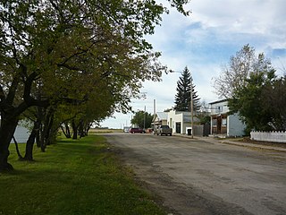
 Main Street
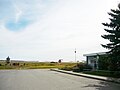 At prairie's edge

