
Seven Persons is a hamlet in Alberta, Canada within Cypress County. It is located approximately 20 kilometres (12 mi) southwest of Medicine Hat on Highway 3 and has an elevation of 755 metres (2,477 ft).
Kingman is a hamlet in central Alberta, Canada within Camrose County. It is located approximately 27 kilometres (17 mi) north of Camrose and has an elevation of 740 metres (2,430 ft).
Tilley is a hamlet in southern Alberta, Canada within the County of Newell. It is located approximately 22 km southeast of the City of Brooks and 78 km northwest of the City of Medicine Hat.

Burdett is a hamlet in Alberta, Canada within the County of Forty Mile No. 8. It is located approximately 71 km (44 mi) west of Medicine Hat and 97 km (60 mi) east of Lethbridge on Highway 3. Also, Burdett is regarded as the site of Canada's first irrigation pivot.
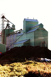
Dunmore is a hamlet in Alberta, Canada within Cypress County, located 2.6 kilometres (1.6 mi) southeast of Medicine Hat's city limits on Highway 1 and the Canadian Pacific Railway mainline. A portion of the hamlet is recognized as a designated place by Statistics Canada.

Benchlands is a hamlet in Alberta within the Municipal District of Bighorn No. 8. The Ghost River is located on the hamlet's south side, while Highway 40 borders the north side.
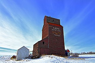
Schuler is a hamlet in southern Alberta, Canada within Cypress County, located 4 kilometres (2.5 mi) east of Highway 41, approximately 40 kilometres (25 mi) northeast of Medicine Hat.

Acadia Valley is a hamlet in southeast Alberta, Canada within the Municipal District (MD) of Acadia No. 34. The MD of Acadia No. 34's municipal office is located in Acadia Valley.
Brule is a hamlet in west-central Alberta, Canada within Yellowhead County. It is located on the northwest shore of Brûlé Lake, approximately 20 kilometres (12 mi) west of Hinton. It has an elevation of 1,040 metres (3,410 ft).
Swalwell is a hamlet in southern Alberta, Canada within Kneehill County. Previously an incorporated municipality, Swalwell dissolved from village status on January 1, 1946, to become part of the Municipal District of Norquay No. 279.
Mountain View is a hamlet in Alberta, Canada within Cardston County. It is located along Highway 5 approximately 25 kilometres (16 mi) west of Cardston and 20 kilometres (12 mi) east of Waterton Lakes National Park near the United States border. It is also a kickoff point for visitors to Police Outpost Provincial Park, 18 kilometers to the south.

Grassy Lake is a hamlet in Alberta, Canada within the Municipal District of Taber. It is located on the Crowsnest Highway (Highway 3), midway between the cities of Lethbridge to the west and Medicine Hat to the east. It is approximately 13 km (8.1 mi) west of Burdett and 34 km (21 mi) east of Taber. It has an elevation of 810 metres (2,660 ft). It was formerly incorporated as a village, dissolving into the Municipal District of Taber on July 1, 1996.
Dixonville is a hamlet in Alberta, Canada within the County of Northern Lights. It is located along the Mackenzie Highway, approximately 43 kilometres (27 mi) north of Grimshaw. It has an elevation of 640 metres (2,100 ft).
Suffield is a hamlet in southern Alberta, Canada within Cypress County. It is located on the Trans-Canada Highway approximately 32 km (20 mi) northwest of Medicine Hat, and just south of CFB Suffield.

Benalto is a hamlet in central Alberta, Canada within Red Deer County. It is located approximately 13 kilometres (8.1 mi) west of the Town of Sylvan Lake. Benalto is also recognized by Statistics Canada as a designated place.
Cluny is a hamlet in Alberta, Canada within Wheatland County. It is located 3 kilometres (1.9 mi) south of Highway 1 on a Canadian Pacific Railway line and Highway 843, approximately 87 kilometres (54 mi) southeast of Calgary. It has an elevation of 570 metres (1,870 ft).
Hilda is a hamlet in southern Alberta, Canada within Cypress County, located 4 kilometres (2.5 mi) east of Highway 41, approximately 67 kilometres (42 mi) northeast of Medicine Hat. In 1910, the post master named the post office "Hilda" after his infant daughter.
Radway is a hamlet in central Alberta, Canada within Thorhild County. It is located 0.75 kilometres (0.47 mi) southeast of Highway 28, approximately 42 kilometres (26 mi) northeast of Fort Saskatchewan and 70 kilometres (43 mi) northeast of Edmonton.
Veinerville is a hamlet in southern Alberta, Canada within Cypress County. It is located 0.5 kilometres (0.31 mi) northwest of Highway 41A, and less than 150 metres (490 ft) from Medicine Hat's east boundary.
Desert Blume is a hamlet in southern Alberta, Canada within Cypress County, adjacent to the southern boundary of Medicine Hat.
