West Carteret, New Jersey

Last updated

West Carteret, New Jersey
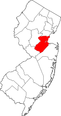
Location map of Middlesex County, New Jersey.svg
Red pog.svg
West Carteret
Location of West Carteret in Middlesex County Inset: Location of county within the state of New Jersey
USA New Jersey location map.svg
Red pog.svg
West Carteret
West Carteret (New Jersey)
Usa edcp location map.svg
Red pog.svg
West Carteret
West Carteret (the United States)
Coordinates: 40°35′40″N74°14′47″W / 40.59444°N 74.24639°W / 40.59444; -74.24639
Country Flag of the United States.svg  United States
State Flag of New Jersey.svg  New Jersey
County Middlesex
Borough Carteret
Elevation
[1]
30 ft (9 m)
GNIS feature ID881691 [1]

West Carteret is an unincorporated community located within Carteret in Middlesex County, in the U.S. state of New Jersey. [2] Joseph Medwick Park is a greenway of parkland along the banks the Rahway River. [3]

Related Research Articles

<span class="mw-page-title-main">Middlesex County, New Jersey</span> County in New Jersey, United States

Middlesex County is a county located in the north-central part of the U.S. state of New Jersey, extending inland from the Raritan Valley region to the northern portion of the Jersey Shore. As of the 2020 United States census, the county was the state's third-most populous county with a population of 863,162, its highest decennial count ever and an increase of 53,304 (+6.6%) from the 2010 census count of 809,858, which in turn reflected an increase of 59,696 (8.0%) from the 750,162 counted in the 2000 census. Middlesex is part of the New York metropolitan area. Many communities within the county serve as commuter towns to and from New York City and other points north. The county is part of the Central Jersey region of the state.

<span class="mw-page-title-main">Ewing Township, New Jersey</span> Township in Mercer County, New Jersey, US

Ewing Township is a township in Mercer County, in the U.S. state of New Jersey. The township falls within the New York metropolitan area as defined by the U.S. Census Bureau. It borders the Philadelphia metropolitan area and is part of the Federal Communications Commission's Philadelphia Designated Market Area. As of the 2020 United States census, the township's population was 37,264, its highest decennial count ever and an increase of 1,474 (+4.1%) from the 35,790 recorded at the 2010 census, which in turn reflected an increase of 83 (+0.2%) from the 35,707 counted in the 2000 census.

<span class="mw-page-title-main">Carteret, New Jersey</span> Borough in Middlesex County, New Jersey, US

Carteret is a borough in northeastern Middlesex County, in the U.S. state of New Jersey. As of the 2020 United States census, the borough's population reached 25,326, its highest decennial count ever and an increase of 2,482 (+10.9%) from the 2010 census count of 22,844, which in turn reflected an increase of 2,135 (+10.3%) from the 20,709 counted in the 2000 census.

<span class="mw-page-title-main">Woodbridge Township, New Jersey</span> Township in Middlesex County, New Jersey, US

Woodbridge Township is a township in northern Middlesex County, in the U.S. state of New Jersey. The township is a regional hub of transportation and commerce for central New Jersey and a major bedroom suburb of New York City, within the New York metropolitan area. Located within the core of the Raritan Valley region, Woodbridge Township hosts the junction of the New Jersey Turnpike and the Garden State Parkway, the two busiest highways in the state, and also serves as the headquarters for the New Jersey Turnpike Authority, which operates both highways.

<span class="mw-page-title-main">Beaufort, North Carolina</span> Town in North Carolina, United States

Beaufort is a town in and the county seat of Carteret County, North Carolina, United States. Established in 1713 and incorporated in 1723, Beaufort is the fourth oldest town in North Carolina . On February 1, 2012, Beaufort was ranked as "America's Coolest Small Town" by readers of Budget Travel Magazine.

<span class="mw-page-title-main">Arthur Kill</span> Navigational channel of the Port of New York and New Jersey

The Arthur Kill is a tidal strait in the New York–New Jersey Harbor Estuary between Staten Island, New York and Union and Middlesex counties, New Jersey. It is a major navigational channel of the Port of New York and New Jersey.

<span class="mw-page-title-main">Province of New Jersey</span> British colony in North America (1664–1673, 1702–1776)

The Province of New Jersey was one of the Middle Colonies of Colonial America and became the U.S. state of New Jersey in 1776. The province had originally been settled by Europeans as part of New Netherland but came under English rule after the surrender of Fort Amsterdam in 1664, becoming a proprietary colony. The English renamed the province after the island of Jersey in the English Channel. The Dutch Republic reasserted control for a brief period in 1673–1674. After that it consisted of two political divisions, East Jersey and West Jersey, until they were united as a royal colony in 1702. The original boundaries of the province were slightly larger than the current state, extending into a part of the present state of New York, until the border was finalized in 1773.

<span class="mw-page-title-main">Rahway River</span> River in the United States

The Rahway River is a river in Essex, Middlesex, and Union Counties, New Jersey, United States, The Rahway, along with the Elizabeth River, Piles Creek, Passaic River, Morses Creek, the Fresh Kills River, has its river mouth at the Arthur Kill.

<span class="mw-page-title-main">Joe Medwick</span> American baseball player (1911-1975)

Joseph Michael Medwick, nicknamed "Ducky" and "Muscles", was an American Major League Baseball player. A left fielder with the St. Louis Cardinals during the "Gashouse Gang" era of the 1930s, he also played with the Brooklyn Dodgers, New York Giants (1943–1945), and Boston Braves (1945). Medwick is the last National League player to win the Triple Crown award (1937).

<span class="mw-page-title-main">Central Jersey</span> Place in New Jersey, United States

Central Jersey, or Central New Jersey, is the middle region of the U.S. state of New Jersey. The designation Central Jersey is a distinct administrative toponym. While New Jersey is often divided into North Jersey and South Jersey, many residents recognize Central Jersey as a distinct third entity. As of the 2020 census, Central Jersey has a population of 3,580,999.

New Jersey's 6th congressional district is represented by Democrat Frank Pallone, who has served the district in Congress since 1993. The district includes the northern and eastern portions of Middlesex County and the coastal areas of Monmouth County, including towns along the Raritan Bay.

Carteret High School is a four-year comprehensive public high school that serves students in ninth through twelfth grades from Carteret in Middlesex County, in the U.S. state of New Jersey, as the lone secondary school of the Carteret School District. The school has been accredited by the Middle States Association of Colleges and Schools Commission on Elementary and Secondary Schools since 1929 and is accredited through January 2027.

<span class="mw-page-title-main">West Allenhurst, New Jersey</span> Place in Monmouth County, New Jersey, United States

West Allenhurst is an unincorporated community located within Ocean Township in Monmouth County, New Jersey, United States. The area is served as United States Postal Service ZIP code 07711. As of the 2000 United States Census, the population for ZIP Code Tabulation Area 07711 was 1,934. West Allenhurst is bordered by Allenhurst to the east, Deal to the northeast, and Interlaken to the south. Major arterial roads in the community are the east-west Corlies Avenue and the north-south Monmouth Road.

<span class="mw-page-title-main">Hornerstown, New Jersey</span> Populated place in Monmouth County, New Jersey, US

Hornerstown is an unincorporated community located within Upper Freehold Township in Monmouth County, in the U.S. state of New Jersey. Hornerstown is located near Cream Ridge and uses the 08514 ZIP code.

Chrome is an unincorporated community located within Carteret in Middlesex County, in the U.S. state of New Jersey. The neighborhood's main street was once a bustling shopping district. The Chemical Coast rail line passes through the area.

<span class="mw-page-title-main">Union Valley, New Jersey</span> Populated place in Middlesex County, New Jersey, US

Union Valley is an unincorporated community located within Monroe Township in Middlesex County, in the U.S. state of New Jersey. Two large age-restricted communities lie within the settlement today, Clearbrook and Concordia. Other than those two communities, the only other buildings in the area are medical offices and facilities and some single-family homes along Union Valley Road.

<span class="mw-page-title-main">Rahway River Parkway</span> Greenway of parkland along the banks the main stem Rahway River

The Rahway River Parkway is a greenway of parkland along the banks the main stem Rahway River and its tributaries in Union County, New Jersey, United States. Created in the 1920s, it was one of the inaugural projects of the newly created Union County Parks Commission. It was designed by the Olmsted Brothers firm, sons of landscape architect Frederick Law Olmsted. The Rahway River Greenway plan expands on the original design. Many of the crossings of the river are late 19th century or early 20th century bridges. The East Coast Greenway uses paths and roads along the parkway.

References

  1. 1 2 "West Carteret". Geographic Names Information System . United States Geological Survey, United States Department of the Interior.
  2. Google (February 15, 2015). "West Carteret, Carteret, New Jersey" (Map). Google Maps . Google. Retrieved February 15, 2015.
  3. "Joseph Medwick Park".