Whitehouse Station, New Jersey | |
---|---|
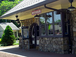
Whitehouse Train Station & Readington Library | |
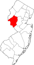
![]() Map of Whitehouse Station highlighted within Hunterdon County. Right: Location of Hunterdon County in New Jersey. | |
Location in Hunterdon County Location in New Jersey | |
Coordinates: 40°36′55″N74°46′14″W / 40.61528°N 74.77056°W [1] | |
Country | ![]() |
State | ![]() |
County | Hunterdon |
Township | Readington |
Area | |
• Total | 2.57 sq mi (6.65 km2) |
• Land | 2.52 sq mi (6.52 km2) |
• Water | 0.05 sq mi (0.13 km2) 3.20% |
Elevation | 174 ft (53 m) |
Population | |
• Total | 3,152 |
• Density | 1,251.29/sq mi (483.14/km2) |
Time zone | UTC−05:00 (Eastern (EST)) |
• Summer (DST) | UTC−04:00 (Eastern (EDT)) |
ZIP Code | 08889 [5] |
Area code | 908 |
FIPS code | 34-80720 [6] [7] [8] |
GNIS feature ID | 881799, [1] 2390505 [3] |
Whitehouse Station, also spelled White House Station, is an unincorporated community and census-designated place (CDP) located within Readington Township, in Hunterdon County, New Jersey. [9] [10] At the 2010 United States Census, the CDP's population was 2,089. [11] Whitehouse Station takes its name from Whitehouse and Abraham Van Horne's 18th century tavern. [12]
New Jersey Transit offers service on the Raritan Valley Line at White House Station. [13]
The area, which is now served only by New Jersey Transit's Raritan Valley Line, used to be a railroad junction, serving as the endpoint of the ill-fated Rockaway Valley Railroad, which ceased operation in 1913. [14]
Whitehouse Station was home to the global headquarters of pharmaceutical giant Merck, which was housed in the modernist Merck Headquarters Building for more than two decades. Merck has shifted its base of operations to Rahway. [15]
On April 5, 2024, at 10:23 AM, the community was struck by a magnitude 4.8 earthquake. The quake saw no major damage and no injuries. At 5:59 PM, on the same day, a second earthquake recorded at magnitude 3.8 struck east of the community in Gladstone, New Jersey. [16]
According to the United States Census Bureau, the CDP had a total area of 1.346 square miles (3.49 km2), including 1.303 square miles (3.37 km2) of land and 0.043 square miles (0.11 km2) of water (3.20%). [6] [17]
Census | Pop. | Note | %± |
---|---|---|---|
1990 | 1,287 | — | |
2000 | 1,951 | 51.6% | |
2010 | 2,089 | 7.1% | |
2020 | 3,152 | 50.9% | |
Population sources: 2000 [18] 2010 [11] [4] |
The 2010 United States census counted 2,089 people, 963 households, and 553 families in the CDP. The population density was 1,602.7 people per square mile (618.8 people/km2). There were 989 housing units at an average density of 758.8 units per square mile (293.0 units/km2). The racial makeup was 91.53% (1,912) White, 2.82% (59) Black or African American, 0.05% (1) Native American, 3.06% (64) Asian, 0.00% (0) Pacific Islander, 1.15% (24) from other races, and 1.39% (29) from two or more races. Hispanic or Latino of any race were 5.27% (110) of the population. [11]
Of the 963 households, 23.2% had children under the age of 18; 46.0% were married couples living together; 8.9% had a female householder with no husband present and 42.6% were non-families. Of all households, 37.1% were made up of individuals and 17.1% had someone living alone who was 65 years of age or older. The average household size was 2.17 and the average family size was 2.87. [11]
19.6% of the population were under the age of 18, 4.3% from 18 to 24, 23.1% from 25 to 44, 31.5% from 45 to 64, and 21.4% who were 65 years of age or older. The median age was 46.6 years. For every 100 females, the population had 82.6 males. For every 100 females ages 18 and older there were 77.3 males. [11]
At the 2000 United States Census [7] there were 1,951 people, 878 households and 531 families living in the CDP. The population density was 583.9 people/km2 (1,512 people/sq mi). There were 905 housing units at an average density of 270.9 units/km2 (702 units/sq mi). The racial makeup of the CDP was 96.05% White, 0.87% African American, 0.97% Asian, 0.56% from other races, and 1.54% from two or more races. Hispanic or Latino of any race were 2.56% of the population. [18]
There were 878 households, of which 24.9% had children under the age of 18 living with them, 47.4% were married couples living together, 10.4% had a female householder with no husband present, and 39.5% were non-families. 34.1% of all households were made up of individuals, and 11.3% had someone living alone who was 65 years of age or older. The average household size was 2.22 and the average family size was 2.86. [18]
Age distribution was 19.9% under the age of 18, 5.1% from 18 to 24, 33.5% from 25 to 44, 26.4% from 45 to 64, and 15.1% who were 65 years of age or older. The median age was 40 years. For every 100 females there were 87.4 males. For every 100 females age 18 and over, there were 79.7 males. [18]
The median household income was $75,111, and the median family income was $92,793. Males had a median income of $60,673 versus $43,438 for females. The per capita income for the CDP was $38,627. None of the families and 1.4% of the population were living below the poverty line, including no under eighteens and 2.9% of those over 64. [18]
There are several nearby points of interest.
People who were born in, residents of, or otherwise closely associated with Whitehouse Station include:
Hunterdon County is a county located in the western section of the U.S. state of New Jersey. At the 2020 census, the county was the state's 4th-least populous county, with a population of 128,947, an increase of 598 (+0.5%) from the 2010 census count of 128,349. Its county seat is Flemington. The county is part of the Central Jersey region of the state.
Country Lake Estates is an unincorporated community and census-designated place (CDP) located within Pemberton Township, in Burlington County, in the U.S. state of New Jersey. As of the 2010 United States Census, the CDP's population was 3,943.
Glendora is an unincorporated community and census-designated place (CDP) located within Gloucester Township, in Camden County, in the U.S. state of New Jersey. As of the 2010 United States Census, the CDP's population was 4,750.
Annandale is an unincorporated community and census-designated place (CDP) located within Clinton Township, in Hunterdon County, in the U.S. state of New Jersey. As of the 2010 United States Census, the CDP's population was 1,695. The Annandale Historic District was listed on the state and national registers of historic places in 1994.
Readington Township is a township located in the easternmost portion of Hunterdon County, in the U.S. state of New Jersey. As of the 2020 United States census, the township's population was 16,128, an increase of two people (+0.0%) from the 2010 census count of 16,126, which in turn reflected an increase of 323 (+2.0%) from the 15,803 counted in the 2000 census.
Avenel is an unincorporated community and census-designated place (CDP) located within Woodbridge Township, in Middlesex County, in the U.S. state of New Jersey. Avenel is approximately 25 miles (40 km) southwest of Midtown Manhattan along the North Jersey Coast rail line
Colonia is an unincorporated community and census-designated place (CDP) in Woodbridge Township, Middlesex County, New Jersey, United States. As of the 2020 United States census, the CDP's population was 18,609.
Concordia is an unincorporated community and census-designated place (CDP) in Monroe Township, Middlesex County, New Jersey, United States. The CDP is oriented around the age restricted gated community of Concordia. As of the 2020 United States census, the CDP's population was 2,455, down from 3,092 in 2010. Prior to 2020, the corner of Concordia known as The Ponds was split off into its own CDP.
Iselin is an unincorporated community and census-designated place (CDP) located within Woodbridge Township, in Middlesex County, in the U.S. state of New Jersey. As of the 2020 United States census, Iselin's population was 20,088, up from 18,695 in 2010.
East Freehold is an unincorporated community and census-designated place (CDP) in Freehold Township, Monmouth County, New Jersey, United States. As of the 2020 census, the CDP population was 4,987.
Wanamassa is an unincorporated community and census-designated place (CDP) within Ocean Township, in Monmouth County, New Jersey, United States. As of the 2020 census, the CDP's population was 4,344. The community was named for Wanamassa, a Native American leader of the 17th century.
Lake Telemark is an unincorporated community and census-designated place (CDP) in Rockaway Township, Morris County, New Jersey, United States. As of the 2020 census, the CDP's population was 1,172.
White Meadow Lake is an unincorporated community and census-designated place (CDP) in Rockaway Township, Morris County, New Jersey, United States. As of the 2020 census, the CDP's population was 8,710.
Cedar Glen Lakes is an unincorporated community and census-designated place (CDP) located within Manchester Township, in Ocean County, in the U.S. state of New Jersey. As of the 2010 United States Census, the CDP's population was 1,421.
Crestwood Village is an unincorporated community and census-designated place (CDP) located within Manchester Township, in Ocean County, in the U.S. state of New Jersey. As of the 2010 United States Census, the CDP's population was 7,907.
Kenilworth is a borough in Union County, in the U.S. state of New Jersey. As of the 2020 United States census, the borough's population was 8,427, an increase of 513 (+6.5%) from the 2010 census count of 7,914, which in turn reflected an increase of 239 (+3.1%) from the 7,675 counted in the 2000 census.
Rahway is a city in southern Union County, in the U.S. state of New Jersey. A bedroom community of New York City, it is centrally located in the Rahway Valley region, in the New York metropolitan area. The city is 15 miles (24 km) southwest of Manhattan and 5 miles (8.0 km) west of Staten Island.
Kenvil is an unincorporated community and census-designated place (CDP) located within Roxbury Township, in Morris County, in the U.S. state of New Jersey. As of the 2020 census, it had a population of 1,806.
Delaware is an unincorporated community and census-designated place (CDP) located along the Delaware River within Knowlton Township in Warren County, New Jersey. It was created as part of the 2010 United States Census. As of the 2010 Census, the CDP's population was 150. The area is served as United States Postal Service ZIP Code 07833.
Finesville is an unincorporated community and census-designated place (CDP) located within Pohatcong Township in Warren County, in the U.S. state of New Jersey. The CDP was defined as part of the 2010 United States Census. As of the 2010 Census, the CDP's population was 175.