Nyanga, Western Cape

Last updated

Nyanga
Nyanga profile 2012.png
Top: Zolani Recreational Centre. Middle: Nyanga taxi rank. Bottom left: Nyanga Community Health Centre. Bottom right: government built RDP houses that are common in the area.
South Africa Western Cape location map.svg
Red pog.svg
Nyanga
South Africa adm location map.svg
Red pog.svg
Nyanga
Africa location map.svg
Red pog.svg
Nyanga
Coordinates: 33°59′S18°35′E / 33.983°S 18.583°E / -33.983; 18.583
Country South Africa
Province Western Cape
Municipality City of Cape Town
Main Place Cape Town
Area
[1]
  Total3.09 km2 (1.19 sq mi)
Population
 (2011) [1]
  Total57,996
  Density19,000/km2 (49,000/sq mi)
Racial makeup (2011)
[1]
   Black African 98.8%
   Coloured 0.3%
   Indian/Asian 0.1%
   White 0.2%
  Other0.7%
First languages (2011)
[1]
   Xhosa 90.2%
   English 3.0%
   Sotho 1.6%
  Other5.1%
Time zone UTC+2 (SAST)
Postal code (street)
7755
PO box
7750

Nyanga is a township in the Western Cape, South Africa. Its name in Xhosa means "moon" and it is one of the oldest black townships in Cape Town. It was established as a result of the migrant labour system. In 1948 [2] black migrants were forced to settle in Nyanga as Langa had become too small. Nyanga was one of the poorest places in Cape Town and is still one of the most dangerous parts of Cape Town. In 2001 its unemployment rate was estimated at being approximately 56% [3] and HIV/AIDS is a huge community issue.

Contents

Nyanga is situated 20 km (12 mi) from Cape Town along the N2 highway, close to the Cape Town International Airport and next to the townships of Gugulethu and Crossroads.

History

The neighbourhood was established in 1946 and, in the same year, was proclaimed a township for migrant labour predominantly from the Eastern Cape. It was initially established as a spillover once the neighbourhood of Langa was fully occupied. [4]

Residents of Nyanga were active in joining a national call to protest against the apartheid laws passed in 1960. Later they were active in the 1976 student uprisings, which had begun on the other side of the country on 16 June 1976 in Soweto against the use of Afrikaans as the primary medium of instruction in schools. [5] Nyanga became notorious for its black-on-black faction fighting that was allegedly perpetrated by police in the early eighties. The local authorities (izibonda) grouped themselves according to their background and used that as their criteria when allocating land.

These cultural differences were allegedly used by the police to stir up violence, and elements of the community were infiltrated by the apartheid regime. This led to emergence of the notoriously violent group called "the witdoeke" (the white scarfs). As a result of these fights Tambo square was formed.[ clarification needed ] [6]

Nyanga comprises nine township subdivisions: Lusaka, KTC, Old Location, Maumau, Zwelitsha, Maholweni "Hostels", White City, Barcelona, Kanana, and Europe.

Crime

The SAPS precinct area for Nyanga in Cape Town as of 2019 after Samora Machel was separated to become its own precinct area. Nyanga SAPS precinct area 2022.png
The SAPS precinct area for Nyanga in Cape Town as of 2019 after Samora Machel was separated to become its own precinct area.

The high rate of violent crime in Nyanga had earned the area the moniker "murder capital of South Africa" with 289 recorded homicides in 2018/19, [7] until it was overtaken by another precinct area in 2022. [8] In the five year period before 2018 a total of 1,473 homicides were recorded in the precinct area. [9] The South African Police Service (SAPS) Nyanga precinct area includes half of the Nyanga neighborhood as well as the adjoining communities of New Crossroads and Brown's Farm. Prior to December 2018 the precinct area also included Samora Machel. [10]

By 2021/22 the number of recorded homicides had declined to 203. [11] In November 2023 Google Maps announced that it would no longer recommend routes through the area following a number of violent incidents targeting motorists that included the death of motorists during the 2023 taxi strike. [12] [13] [14]

Government institutions and public services

Several government institutions maintain a presence in Nyanga in order to provide various vital services to the community:

Churches

Some of the churches that are located in Nyanga are:

See also

Related Research Articles

<span class="mw-page-title-main">Cape Town</span> Legislative capital of South Africa

Cape Town is the legislative capital of South Africa. It is the country's oldest city and the seat of the Parliament of South Africa. It is the country's second-largest city, after Johannesburg, and the largest in the Western Cape. The city is part of the City of Cape Town metropolitan municipality.

<span class="mw-page-title-main">People Against Gangsterism and Drugs</span> Violent South African vigilante group

People Against Gangsterism and Drugs (PAGAD) is a group formed in 1996 in the Cape Flats area of Cape Town, South Africa. The organisation came to prominence for acts against gangsters, including arson and murder.

<span class="mw-page-title-main">Cape Flats</span> Area of Cape Town, South Africa

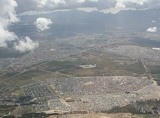
The Cape Flats is an expansive, low-lying, flat area situated to the southeast of the central business district of Cape Town. The Cape Flats is also the name of an administrative region of the City of Cape Town, which lies within the larger geographical area.

<span class="mw-page-title-main">Western Cape</span> Province of South Africa on the south-western coast

The Western Cape is a province of South Africa, situated on the south-western coast of the country. It is the fourth largest of the nine provinces with an area of 129,449 square kilometres (49,981 sq mi), and the third most populous, with an estimated 7 million inhabitants in 2020. About two-thirds of these inhabitants live in the metropolitan area of Cape Town, which is also the provincial capital. The Western Cape was created in 1994 from part of the former Cape Province. The two largest cities are Cape Town and George.

<span class="mw-page-title-main">Masiphumelele</span> Suburb of Cape Town, Western Cape, South Africa

Masiphumelele is a township on the Cape Peninsula, South Africa, situated between Kommetjie, Capri Village and Noordhoek.

<span class="mw-page-title-main">Khayelitsha</span> Suburb of Cape Town, in Western Cape, South Africa

Khayelitsha is a township in Western Cape, South Africa, on the Cape Flats in the City of Cape Town Metropolitan Municipality. The name is Xhosa for New Home. It is reputed to be one of the largest and fastest-growing townships in South Africa.

<span class="mw-page-title-main">Gugulethu</span> Suburb of Cape Town, in Western Cape, South Africa

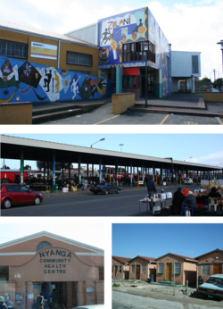
Gugulethu is a township in the Western Cape, South Africa and is 15 km from Cape Town. Its name is a contraction of igugu lethu, which is Xhosa for our pride. The township was established along with Nyanga in the 1960s.

<span class="mw-page-title-main">Crime in South Africa</span> Overview of crime in South Africa

Crime in South Africa includes all violent and non-violent crimes that take place in the country of South Africa, or otherwise within its jurisdiction. When compared to other countries South Africa has notably high rates of violent crime and has a reputation for consistently having one of the highest murder rates in the world. The country also experiences high rates of organised crime relative to other countries.

<span class="mw-page-title-main">Mfuleni</span> Cape Flats suburb of Cape Town

Mfuleni is a relatively new township about 32 kilometres from central Cape Town, South Africa. It is a predominantly Black township, although there are also some Coloured members of the community.

Lwandle/Nomzamo is a small township in the Helderberg basin just outside Strand in the Western Cape of South Africa. Both names are sometimes used interchangeably referring to both places. This may be attributed to the fact that Nomzamo was born as a result of overpopulation in Lwandle area which initially designed as a cheap accommodation for "single male workers" during the apartheid years.

<span class="mw-page-title-main">Crossroads, Western Cape</span> Suburb of Cape Town in Western Cape, South Africa

Crossroads is a high-density township in the Western Cape, South Africa.

<span class="mw-page-title-main">Manenberg</span> Suburb of Cape Town, in Western Cape, South Africa

Manenberg is a township of Cape Town, South Africa, that was created by the apartheid government for low-income Coloured families in the Cape Flats in 1966 as a result of the forced removal campaign by the National Party. It has an estimated population of 52,000 residents. The area consists of rows of semi-detached houses and project-like flats, known as "korre". The township is located about 20 km away from the city centre of Cape Town. It is separated from neighbouring Nyanga and Gugulethu townships by a railway line to the east and from Hanover Park by the Sand Industria industrial park to the west and Heideveld to the north. The northern part of Manenberg has wealthy people that are mostly Muslims. The rest of Manenberg has poor people that are mostly associated with Christianity.

<span class="mw-page-title-main">Western Cape Anti-Eviction Campaign</span> Movement in Cape Town, South Africa

The Western Cape Anti-Eviction Campaign was a non-racial popular movement made up of poor and oppressed communities in Cape Town, South Africa. It was formed in November 2000 with the aim of fighting evictions, water cut-offs and poor health services, obtaining free electricity, securing decent housing, and opposing police brutality.

Prior to 1994, immigrants from elsewhere faced discrimination and even violence in South Africa due to competition for scarce economic opportunities. After majority rule in 1994, contrary to expectations, the incidence of xenophobia increased. In 2008, at least 62 people were killed in the xenophobic uprising and attacks. In 2015, another nationwide spike in xenophobic attacks against immigrants in general prompted a number of foreign governments to begin repatriating their citizens. A Pew Research poll conducted in 2018 showed that 62% of South Africans expressed negative sentiment about foreign nationals living and working in South Africa, believing that immigrants are a burden on society by taking jobs and social benefits and that 61% of South Africans thought that immigrants were more responsible for crime than other groups. There is no factual evidence to substantiate the notion that immigrants are the main culprits of criminal activity in South Africa, even though the claim is incorrectly made in sometimes by politicians and public figures. Between 2010 and 2017 the number of foreigners living in South Africa increased from 2 million people to 4 million people. The proportion of South Africa's total population that is foreign born increased from 2.8% in 2005 to 7% in 2019, according to the United Nations International Organization for Migration, South Africa is the largest recipient of immigrants on the African continent.

<span class="mw-page-title-main">Philippi, Western Cape</span> Suburb of Cape Town

Philippi is a large urban and semi-urban area in Cape Town's Cape Flats region, in the Western Cape, South Africa. It comprises the Philippi Horticultural Area to the west, and the neighbourhoods of Brown's Farm, Philippi East and Samora Machel located within its eastern half. The neighbourhoods of Gugulethu and Nyanga are located to its north. The horticultural area is sparsely populated compared to the surrounding city and contains many farms.

Lwandle is a township in Strand, a town in the eastern part of the Cape Town Metro in the Western Cape province of South Africa. Administratively it is a suburb of the City of Cape Town. Under Apartheid it was a group area for black people and is still predominantly populated by this community.

Dunoon is a city in the Western Cape province of South Africa. The first erf for Dunoon was surveyed in 1996. As formal housing was built, shacks developed rapidly.

<span class="mw-page-title-main">Hanover Park, Cape Town</span> Suburb of Cape Town, in Western Cape, South Africa

Hanover Park is a neighborhood of the City of Cape Town in the Western Cape province of South Africa

<span class="mw-page-title-main">M9 (Cape Town)</span> Metropolitan route in the City of Cape Town, South Africa

The M9 is a long metropolitan route in the City of Cape Town, South Africa. It connects Sir Lowry's Pass Village with Wynberg via Somerset West, Firgrove, Macassar, Khayelitsha and Nyanga.

Wallace Amos Mgoqi was a South African attorney, businessman and activist.

References

  1. 1 2 3 4 "Main Place Nyanga". Census 2011.
  2. Catherine Besteman (2008). Transforming Cape Town. University of California Press. ISBN   978-0-520-94264-6.
  3. "City of Cape Town by Ward". capetown.gov.za. Retrieved 2012-08-15.
  4. Leander (2013-11-08). "Nyanga Township". South African History Online. Retrieved 2019-02-16.
  5. sahoboss (2011-03-31). "Cape Schools Join the Revolt". South African History Online. Retrieved 2019-02-16.
  6. "Goldstone Commission : Report on Violence at Crossroads Camp March-June 1993". Archived from the original on 2013-09-03. Retrieved 2013-08-30.
  7. Isaacs, Lauren. "Nyanga remains SA's murder capital, but CPF vows to make area safer". ewn.co.za. Retrieved 2023-11-15.
  8. Mlamla, Sisonke (22 February 2022). "Nyanga no longer murder capital of SA after police and City of Cape Town interventions". Cape Argus .
  9. "Fear Stalks Township Streets of South Africa Murder Capital". Bloomberg.com. 2018-10-16. Retrieved 2023-11-15.
  10. Masson, Eunice (2022-05-17). "Police resources might further drop in Nyanga, former 'murder capital' of SA". The Mail & Guardian. Retrieved 2023-11-15.
  11. "4th quarter crime stats shows Nyanga murder rate continues to decrease". Western Cape Government. Retrieved 2023-11-15.
  12. Marks, Samane Jnr (2023-11-13). "Google Maps to avoid Cape Town township route after attacks on motorists". Daily Maverick. Retrieved 2023-11-15.
  13. Solomons, Lisalee. "Google Maps will no longer suggest routes through Cape Town crime hotspot Nyanga". News24. Retrieved 2023-11-15.
  14. "Family of Essex surgeon claims South Africa police chatted as he lay dying". BBC News. 2023-11-09. Retrieved 2023-11-15.
  15. "Nyanga Home Affairs Office". Western Cape Government. Retrieved 27 September 2021.
  16. "Satelite Offices". The South African Department of Employment and Labour. Retrieved 27 September 2021.
  17. "Nyanga Community Health Clinic". Western Cape Government. Retrieved 27 September 2021.
  18. "Masincedane Clinic". Western Cape Government. Retrieved 27 September 2021.
  19. "Services SAPS (South African Police Service)". South African Police Service. Retrieved 27 September 2021.
  20. "Nyanga Public Library". City of Cape Town. Retrieved 27 September 2021.
  21. "Tribute For a Gifted Man of the Lord". IOL. 3 August 2012. Retrieved 20 September 2021.
  22. "Holy Cross Nyanga". World Anglican. Retrieved 20 September 2021.
  23. "Region 3 - Central Cape Flats". Western Province Baptist Association. Retrieved 20 September 2021.
  24. "Nyanga - Archdiocese of Cape Town". Archdiocese of Cape Town. 12 November 2013. Retrieved 20 September 2021.
  25. "Gallery: Prince Harry and Meghan Markle Visit Cape Town". Eyewitness News. Retrieved 20 September 2021.