Related Research Articles

Russell Cave National Monument is a U.S. national monument in northeastern Alabama, United States, close to the town of Bridgeport. The monument was established on May 11, 1961, when 310 acres (1.3 km2) of land were donated by the National Geographic Society to the American people. It is now administered and maintained by the National Park Service. The national monument was listed on the National Register of Historic Places on October 15, 1966.

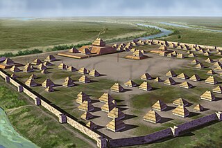
Etowah Indian Mounds (9BR1) are a 54-acre (220,000 m2) archaeological site in Bartow County, Georgia, south of Cartersville. Built and occupied in three phases, from 1000–1550 CE, the prehistoric site is located on the north shore of the Etowah River.

Angel Mounds State Historic Site, an expression of the Mississippian culture, is an archaeological site managed by the Indiana State Museum and Historic Sites that includes more than 600 acres of land about 8 miles (13 km) southeast of present-day Evansville, in Vanderburgh and Warrick counties in Indiana. The large residential and agricultural community was constructed and inhabited from AD 1100 to AD 1450, and served as the political, cultural, and economic center of the Angel chiefdom. It extended within 120 miles (190 km) of the Ohio River valley to the Green River in present-day Kentucky. The town had as many as 1,000 inhabitants inside the walls at its peak, and included a complex of thirteen earthen mounds, hundreds of home sites, a palisade (stockade), and other structures.

Wickliffe Mounds is a prehistoric, Mississippian culture archaeological site located in Ballard County, Kentucky, just outside the town of Wickliffe, about 3 miles (4.8 km) from the confluence of the Ohio and Mississippi rivers. Archaeological investigations have linked the site with others along the Ohio River in Illinois and Kentucky as part of the Angel phase of Mississippian culture. Wickliffe Mounds is controlled by the State Parks Service, which operates a museum at the site for interpretation of the ancient community. Listed on the National Register of Historic Places, it is also a Kentucky Archeological Landmark and State Historic Site.

The Grave Creek Mound in the Ohio River Valley in West Virginia is one of the largest conical-type burial mounds in the United States, now standing 62 feet (19 m) high and 240 feet (73 m) in diameter. The builders of the site, members of the Adena culture, moved more than 60,000 tons of dirt to create it about 250–150 BC.
Indian Mound Park, also known as Shell Mound Park or Indian Shell Mound Park, is a park and bird refuge located on the northern shore of Dauphin Island, a barrier island of Mobile County, Alabama in the United States. In addition to the many birds which visit, a wide variety of botanical species contribute to the natural offerings. The site is historically significant due to the presence of prehistoric Indian shell middens, mounds composed of discarded oyster shells. The park was added to the National Register of Historic Places on August 14, 1973. It is administered by the Alabama Department of Conservation and Natural Resources.


The Nodena site is an archeological site east of Wilson, Arkansas, and northeast of Reverie, Tennessee, in Mississippi County, Arkansas, United States. Around 1400–1650 CE an aboriginal palisaded village existed in the Nodena area on a meander bend of the Mississippi River. The Nodena site was discovered and first documented by Dr. James K. Hampson, archaeologist and owner of the plantation on which the Nodena site is located. Artifacts from this site are on display in the Hampson Museum State Park in Wilson, Arkansas. The Nodena site is the type site for the Nodena phase, believed by many archaeologists to be the province of Pacaha visited by Spanish explorer Hernando de Soto in 1542.
Parkin Archeological State Park, also known as Parkin Indian Mound, is an archeological site and state park in Parkin, Cross County, Arkansas. Around 1350–1650 CE an aboriginal palisaded village existed at the site, at the confluence of the St. Francis and Tyronza rivers. Artifacts from this site are on display at the site museum. The Parkin site is the type site for the Parkin phase, an expression of the Mississippian culture from the Late Mississippian period. Many archeologists believe it to be part of the province of Casqui, documented as visited by Spanish explorer Hernando de Soto in 1542. Archeological artifacts from the village of the Parkin people are dated to 1400–1650 CE.

The Kincaid Mounds Historic Site c. 1050–1400 CE, is a Mississippian culture archaeological site located at the southern tip of present-day U.S. state of Illinois, along the Ohio River. Kincaid Mounds has been notable for both its significant role in native North American prehistory and for the central role the site has played in the development of modern archaeological techniques. The site had at least 11 substructure platform mounds, and 8 other monuments.

The Anna site is a prehistoric Plaquemine culture archaeological site located in Adams County, Mississippi, 10 miles (16 km) north of Natchez. It is the type site for the Anna phase of the Natchez Bluffs Plaquemine culture chronology. It was declared a National Historic Landmark on September 14, 1993.

Toqua was a prehistoric and historic Native American site in Monroe County, Tennessee, located in the Southeastern Woodlands. Toqua was the site of a substantial ancestral town that thrived during the Mississippian period. Toqua had a large earthwork 25-foot (7.6 m) platform mound built by the town's Mississippian-era inhabitants, in addition to a second, smaller mound. The site's Mississippian occupation may have been recorded by the Spanish as the village of Tali, which was documented in 1540 by the Hernando de Soto expedition. It was later known as the Overhill Cherokee town Toqua, and this name was applied to the archeological site.

Mummy Cave is a rock shelter and archeological site in Park County, Wyoming, United States, near the eastern entrance to Yellowstone National Park. The site is adjacent to the concurrent U.S. Routes 14/16/20, on the left bank of the North Fork of the Shoshone River at an altitude of 6,310 feet (1,920 m) in Shoshone National Forest.

The C.H. Nash Museum at Chucalissa is located on and exhibits excavated materials of the Mississippian culture archaeological site known as Chucalissa which means "abandoned house" in Chickasaw. The site is located adjacent to the T. O. Fuller State Park within the city of Memphis, Tennessee, United States. Chucalissa was designated National Historic Landmark in 1994 due to its importance as one of the best-preserved and major prehistoric settlement sites in the region.

The Canfield Island Site, also known as Archeological Site 36LY37, is an archaeological site in Lycoming County, Pennsylvania, United States. Located on Canfield Island in the West Branch Susquehanna River, the site lies east of the city of Williamsport in Loyalsock Township. It is believed to have been inhabited by prehistoric Native Americans for thousands of years, with the oldest discoveries dating back to more than one millennium before Christ.
Garden Creek site is an archaeological site located 24 miles (39 km) west of Asheville, North Carolina in Haywood County, on the south side of the Pigeon River and near the confluence of its tributary Garden Creek. It is near modern Canton and the Pisgah National Forest. The earliest human occupation at the site dates to 8000 BCE. The 12-acre site features remains of two villages (31Hw7) occupied first in the Woodland period and, most prominently, in the Pisgah phase associated with the South Appalachian Mississippian culture. A total of four earthwork mounds have been found at the site; three have been excavated.
The Little Egypt site was an archaeological site located in Murray County, Georgia, near the junction of the Coosawattee River and Talking Rock Creek. The site originally had three platform mounds surrounding a plaza and a large village area. It was destroyed during the construction of the Dam of Carters Lake in 1972. It was situated between the Ridge and Valley and Piedmont sections of the state in a flood plain. Using Mississippian culture pottery found at the site archaeologists dated the site to the Middle and Late South Appalachian culture habitation from 1300 to 1600 CE during the Dallas, Lamar, and Mouse Creek phases.
The Chauga Mound (38OC1) is an archaeological site once located on the northern bank of the Tugaloo River, about 1,200 feet (370 m) north of the mouth of the Chauga River in present-day Oconee County, South Carolina. The earthen platform mound and former village site were inundated by creation of Lake Hartwell after construction of the Hartwell Dam on the Savannah River, which was completed in 1962.
The Carlston Annis Shell Mound is a prominent archaeological site in the western part of the U.S. state of Kentucky. Located along the Green River in Butler County, this shell midden has been declared a historic site because of its archaeological value.

The Upper Hay Lake Archeological District is a prehistoric Native American archaeological site in Jenkins Township, Minnesota, United States. It consists of about 75 linear mounds—including one of the state's longest at 725 feet (221 m)—plus the sites of a village and a portage. The mound grouping has also been dubbed Fort Poualak. The site was listed on the National Register of Historic Places in 1978 for having local significance in the theme of archaeology. It was nominated for indicating an area of substantial activity during the Blackduck phase of the Late Woodland period.
References
- 1 2 3 "National Register Information System". National Register of Historic Places . National Park Service. July 9, 2010.
- 1 2 David W. Chase (August 8, 1984). "National Register of Historic Places Inventory-Nomination Form: Archeological Site No. 1WI50" (PDF). National Forest Service. Alabama Historical Commission. Archived from the original (PDF) on January 16, 2014. Retrieved July 29, 2012.
| Topics | |
|---|---|
| Lists by state |
|
| Lists by insular areas | |
| Lists by associated state | |
| Other areas | |
| Related | |

| | This article about a property in Alabama on the National Register of Historic Places is a stub. You can help Wikipedia by expanding it. |