Harharia Chak is a census town in the Raninagar I CD block of the Domkal subdivision in the Murshidabad district in the Indian state of West Bengal.
Lalgola is a census town in the Lalgola CD block in the Lalbag subdivision of Murshidabad district, West Bengal. It is situated about 225 kilometres (140 mi) north of Kolkata, near the head of the Ganges delta. It is a terminal railway station on the Ranaghat-Lalgola branch line. The distance between Lalgola railway station and Krishnapur railway station is one of the shortest distance between two railway stations in India (1.7 km). It is also a border checkpoint but presently non functional due to some unknown reasons.
Domkal is a town and headquarters of the Domkal Subdivision in Murshidabad district in the Indian state of West Bengal.
Bhagawangola is a village, with a police station, not identified in 2011 census as a separate place, in the Bhagwangola I CD block in the Lalbag subdivision of Murshidabad district in the state of West Bengal, India.

Jalangi is a village, with a police station, identified in 2011 census, in Jalangi CD Block in Domkol subdivision of Murshidabad district in the state of West Bengal, India. This village is situated beside the Padma River.

Murshidabad-Jiaganj is a community development block that forms an administrative division in the Lalbag subdivision of Murshidabad district in the Indian state of West Bengal.

Islampur is a census town in the Raninagar I CD block in the Domkol subdivision of the Murshidabad district in the state of West Bengal, India.
Sagarpara is a village and gram panchayat in the Jalangi CD block in the Domkol subdivision of Murshidabad district in West Bengal, India. It is 2.5 kilometres from the Padma River.
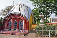
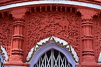
Kiriteswari Temple is situated in Kiritkona village under the Nabagram CD block in the Lalbag subdivision of Murshidabad district in the state of West Bengal. This is one of the Shakti Pithas among the 51 peeths. In September 2023 this area was selected as the best tourism village of India.
Gram Salkia is a village in the Burwan CD block in the Kandi subdivision of Murshidabad district in the state of West Bengal, India.
Ranitala is a village, with a police station, in the Bhagawangola II CD block in the Lalbag subdivision of Murshidabad district in the state of West Bengal, India.
Raninagar is a town,and special village form Murshidabad district, with a police station, note identified in 2011 census as a separate town, in the Raninagar II CD block in the Domkol subdivision of Murshidabad district in the state of West Bengal, India.
Kasbagoas is a village in the Raninagar I CD block in the Domkol subdivision of Murshidabad district in the state of West Bengal, India.
Shaikhpara is a town, with a college, not identified in 2011 census as a separate place, in the Raninagar II CD block in the Domkol subdivision of Murshidabad district in the state of West Bengal, India. It is possibly part of Babaltali village in the census records. Babaltali is a big village with a population of 20,177 in 2011.
Kismattatla is a village in the Bhagawangola I CD block in the Lalbag subdivision of Murshidabad district in the state of West Bengal, India.
Krishnapur is a village in the Lalgola CD block in the Lalbag subdivision of Murshidabad district in the state of West Bengal, India.
Sadikhanr Diar is a village in the Jalangi CD block in the Domkal subdivision of Murshidabad district in the state of West Bengal, India.
Bhagirathpur is a village and a gram panchayat in the Domkal CD block in the Domkol subdivision of Murshidabad district in the state of West Bengal, India.

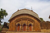
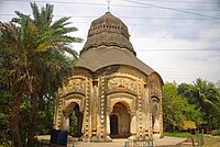
Char Bangla Temples, are located at Baranagar in the Murshidabad-Jiaganj CD block in the Lalbag subdivision of Murshidabad district in the Indian state of West Bengal.

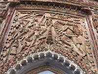
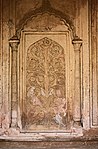
Bhavaniswar Mandir, is located at Baranagar in the Murshidabad-Jiaganj CD block in the Lalbag subdivision of Murshidabad district in the Indian state of West Bengal.