Black Mountain (Maricopa County, Arizona)

Last updated
Black Mountain
BlackMountainSouthview.jpg
Black Mountain as viewed from the south
Highest point
Elevation 3,403 ft (1,037 m)  NAVD 88 [1]
Prominence 1,018 ft (310 m) [2]
Coordinates 33°48′55″N111°56′29″W / 33.815243153°N 111.941358858°W / 33.815243153; -111.941358858 Coordinates: 33°48′55″N111°56′29″W / 33.815243153°N 111.941358858°W / 33.815243153; -111.941358858 [1]
Geography
USA Arizona relief location map.svg
Red triangle with thick white border.svg
Black Mountain
Location Maricopa County, Arizona, U.S.
Topo map USGS Cave Creek, AZ

Black Mountain is located in north-central Maricopa County, Arizona, between the towns of Carefree and Cave Creek.

Contents

Geology

The western face of Black Mountain. The rock formation in the foreground is the same phyllite formation found on Black Mountain. Black Mountain west face.jpg
The western face of Black Mountain. The rock formation in the foreground is the same phyllite formation found on Black Mountain.

The mountain is composed of two main rock types that are roughly divided between western and eastern halves of the mountain. The west side of the mountain is composed of a ~250 m. bed of meta-sedimentary rock [3] distinguishable as phyllite and argillite. From a distance, the meta-sedimentary rock is easily mistaken for basalt, which is common in the area, however basalt is not found on Black Mountain. The phyllite has a slaty cleavage and is foliated in all directions, a result of shortening due to pressure-solution volume-diffusion of as much as 50%. As a result of shortening, streambeds of nearby washes are filled with black alluvium.

The western face meta-sedimentary beds strike ~120, 45. When fully illuminated by afternoon sun, the dipping, angular rocks resemble overlapping flatirons. The meta-sedimentary beds rise nearly 1300 feet above the local topography. Black Mountain rises 3398 feet above sea level.

The eastern side of the mountain is composed of a granitic intrusion into the meta-sedimentary rock. The granite is part of a batholith dated 14 m.y.a locally known as Camelback Granite. It extends southward from Black Mountain and is expressed in outcrops in the McDowell Mountains, the Union Hills, and Camelback Mountain. Texturally, the granite varies from a large crystal with phenocrysts of up to 2.5 cm., to a finer grained crystal texture. Larger grained Camelback granite shows large joints fractured both vertically and horizontally. It is weathered into spheroidal boulder columns and balanced rock formations. Jointing in the finer grained granite is smaller and proportional to grain size.

The granitic half of Black Mountain tapers to a flat-topped peak that rises to a height just below that of the pointed, black phyllite peak of the western side. The two units meet as a saddle between the twin peaks of meta-argillite/phyllite and granite.

Phyllite embayed in granite along contact. The phyllite piece is ~20 cm. Embayed phyllite in granite.jpg
Phyllite embayed in granite along contact. The phyllite piece is ~20 cm.

Along the contact on the eastern side of the mountain, clasts of pelitic schist can be found embayed in the large-grained granite. The granite at the contact is gray in color, having been discolored by the sedimentary rock during emplacement. Clasts of smaller grained granite are also found in the large-grained granite. The meta-sedimentary rock along with the granite batholith that forms Black Mountain are remnants of what laid hidden beneath a sea and underground, that are now exposed by headward erosion that continues northward today into Arizona's Transition Zone. The highly shortened and foliated phyllite began as a mudstone which was metamorphosed to shale. The shale was then subjected to pressure-solution volume-diffusion; the rock was metamorphosed while deeply buried then subjected to heating during the emplacement of the batholith. The phyllite at the granite contact formed a weak horizon, which assisted the decollement process after the batholith was emplaced. These chloritic rocks acted as a lubricated sheet, effectively sliding off the batholith and tilting to the northwest during the Tertiary extension event. To the south, grabens that formed by normal faulting during crustal extension, are filled by the alluvium from the subsequent erosion.

People and Culture of the Black Mountain/Desert Foothills Area

While Carefree and Cave Creek are today a home for upper-income retirees and an enclave for artists and entrepreneurs, the first inhabitants of the area surrounding Black Mountain were Native Americans known as the Hohokam, who appear at about 750 A.D. They were an agrarian society of hunters and gatherers who also used irrigation to maintain crops. Their "waffle gardens" can still be seen in the Spur Cross Ranch reserve area North of Cave Creek. The remains of dwellings of the Hohokam are called "pit houses". The best example of a pit house is located at the Sears-Kay ruin located northeast of Black Mountain near Seven Springs, although pit houses have been uncovered during construction of homes in Cave Creek. Pit houses were constructed with a rock-wall base and covered with roof supports of long branches covered with thatch.

The Sears-Kay ruins mark a time in Hohokam history when they had moved to high ground with views into the Valley, presumably to see their enemies, raiding tribes of Yavapai and Tonto Apache, approaching from a long distance. Evidence of the Hohokam living in the Black Mountain area disappears around 1450 A.D., when some anthropologists believe they moved into the Valley using their skill at irrigation and possibly becoming the Pima. Before disappearing entirely, the Hohokam stopped cremating their dead and began burying remains. Some believe the Hohokam ran out of wood for fires. Scarcity of wood was likely due to a long drought. Others believe there was a large fire which led to the sudden disappearance of the Hohokam.

From about 1450 to the 1870s the area was considered Apache territory. Bands of marauding Tonto Apache largely controlled the area. Although they lived farther north, the Apache were raiders that patrolled the area and when efforts were made to establish "rancharitas" in the Desert Foothills, bands of Apache would attack, and often kill, the trespassers. Efforts to settle the territory were intensified in the 1870s with the discovery of gold in the area. This was when Gen. George Stoneman and his troops built Military Road, a main artery in modern-day Cave Creek, to protect the miners and anyone else crossing through the Desert Foothills. A remount station where riders could rest and pick up a fresh horse before continuing on their journey was located at near what is now Spur Cross Road in Cave Creek.

After the U.S. Military had eliminated the threat of attack from the Apache, mining claims began to spring up in the Cave Creek area. The first discovery of gold was made by William Rowe on what became known (optimistically) as Gold Hill near the Tonto Hills northeast of Cave Creek. The area around Black Mountain was referred to as the Cave Creek Mining District, but the district was never formally established. [4] In 1878 the first stamp mill opened at the Golden Star Mine on Continental Mountain. The most productive mine in the area was the Phoenix Mine was located at what is today the entrance to the Spur Cross Conservancy area. Tailings from the mining operation are all that remain today. The mine was closed by 1905, and most other mining efforts in the area had stopped by 1910.

In the late 1880s cattle and sheep ranches were being established wherever streams provided adequate water to support a herd. But recurring drought and overpopulation of herd animals soon lead to water shortages, and the cattle ranchers were forced to look for new ways to support themselves. The answer for some ranchers was to transform cattle ranches into dude ranches where Easterners would come for a taste of the wild west experience. Spur Cross Ranch was one of the most successful dude ranches in the Black Mountain area, and remained in business until the 1970s when its owner died in a plane crash while attempting to land on a runway located on the ranch.

See also

Related Research Articles

Superstition Mountain Landform in Arizona, United States

Superstition Mountain is a prominent mountain and regional landmark located in the Phoenix metropolitan area of Arizona, immediately east of Apache Junction and north of Gold Canyon. It anchors the west end of the federally designated Superstition Wilderness Area and is a popular outdoor recreation destination, home to numerous trails for hiking and horseback riding. The legend of the Lost Dutchman's Gold Mine centers around the mountain.

Salt River (Arizona) River in Gila and Maricopa counties in Arizona, United States

The Salt River is a river in Gila and Maricopa counties in Arizona, United States, that is the largest tributary of the Gila River. The river is about 200 miles (320 km) long. Its drainage basin is about 13,700 square miles (35,000 km2) large. The longest of the Salt River's many tributaries is the 195-mile (314 km) Verde River. The Salt's headwaters tributaries, the Black River and East Fork, increase the river's total length to about 300 miles (480 km). The name Salt River comes from the fact that the river flows over large salt deposits shortly after the merging of the White and Black Rivers.

Chiricahua Mountains Mountain range in Arizona, United States

The Chiricahua Mountains massif is a large mountain range in southeastern Arizona which is part of the Basin and Range province of the west and southwestern United States and northwest Mexico; the range is part of the Coronado National Forest. The highest point, Chiricahua Peak, rises 9,759 feet (2,975 m) above sea level, approximately 6,000 feet (1,800 m) above the surrounding valleys. The range takes its name from the Chiricahua Apaches native to the region.

Camelback Mountain Landform in Maricopa County, Arizona

Camelback Mountain is a mountain in Phoenix, Arizona, United States. The English name is derived from its shape, which resembles the hump and head of a kneeling camel. The mountain, a prominent landmark of the Phoenix metropolitan area, is located in the Camelback Mountain Echo Canyon Recreation Area between the Arcadia neighborhood of Phoenix and the town of Paradise Valley. It is a popular recreation destination for hiking and rock climbing.

Argillite Sedimentary rock, mostly of indurated clay particles

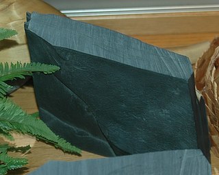
Argillite is a fine-grained sedimentary rock composed predominantly of indurated clay particles. Argillaceous rocks are basically lithified muds and oozes. They contain variable amounts of silt-sized particles. The argillites grade into shale when the fissile layering typical of shale is developed. Another name for poorly lithified argillites is mudstone. These rocks, although variable in composition, are typically high in aluminium and silica with variable alkali and alkaline earth cations. The term pelitic or pelite is often applied to these sediments and rocks. Metamorphism of argillites produces slate, phyllite, and pelitic schist.

Geology of the Australian Capital Territory Overview of the geology of the Australian Capital Territory

The geology of the Australian Capital Territory includes rocks dating from the Ordovician around 480 million years ago, whilst most rocks are from the Silurian. During the Ordovician period the region—along with most of eastern Australia—was part of the ocean floor. The area contains the Pittman Formation consisting largely of Quartz-rich sandstone, siltstone and shale; the Adaminaby Beds and the Acton Shale.

Sierra Ancha Mountain range in Gila County, Arizona

The Sierra Ancha is a mountain range in Gila County, in central Arizona. It lies between Roosevelt Lake to the south, the Tonto Basin to the west, Cherry Creek to the east, and Pleasant Valley to the north. The range is one of several, including the Bradshaw Mountains, Mingus Mountain of the Black Hills, and the Mazatzal Mountains, which form a transitional zone between the lowland deserts of southern Arizona and the Colorado Plateau of northeastern Arizona. The highest point in the range is Aztec Peak, at an elevation of 2345 m (7694 ft).

Foliation (geology)

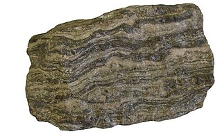
Foliation in geology refers to repetitive layering in metamorphic rocks. Each layer can be as thin as a sheet of paper, or over a meter in thickness. The word comes from the Latin folium, meaning "leaf", and refers to the sheet-like planar structure. It is caused by shearing forces, or differential pressure. The layers form parallel to the direction of the shear, or perpendicular to the direction of higher pressure. Nonfoliated metamorphic rocks are typically formed in the absence of significant differential pressure or shear. Foliation is common in rocks affected by the regional metamorphic compression typical of areas of mountain belt formation.

Yavapai Native American tribe

The Yavapai are a Native American tribe in Arizona. Historically, the Yavapai – literally “people of the sun” – were divided into four geographical bands who identified as separate, independent peoples: the Ɖo:lkabaya, or Western Yavapai; the Yavbe', or Northwestern Yavapai; the Guwevkabaya, or Southeastern Yavapai; and the Wi:pukba, or Northeastern Yavapai – Verde Valley Yavapai.

Boulder Batholith

The Boulder Batholith is a relatively small batholith in southwestern Montana, United States, exposed at the surface as granite and serving as the host rock for rich mineralized deposits at Butte and other locations. The batholith lies roughly between Butte and Helena, and between the Deer Lodge Valley and the Broadwater Valley. The volcanic Elkhorn Mountains are a large mass of forested lava associated with the batholith.

Bass Formation Lithostratigraphic unit found in Arizona, US

The Bass Formation, also known as the Bass Limestone, is a Mesoproterozoic rock formation that outcrops in the eastern Grand Canyon, Coconino County, Arizona. The Bass Formation erodes as either cliffs or stair-stepped cliffs. In the case of the stair-stepped topography, resistant dolomite layers form risers and argillite layers form steep treads. In general, the Bass Formation in the Grand Canyon region and associated strata of the Unkar Group-rocks dip northeast (10°–30°) toward normal faults that dip 60+° toward the southwest. This can be seen at the Palisades fault in the eastern part of the main Unkar Group outcrop area. In addition, thick, prominent, and dark-colored basaltic sills intrude across the Bass Formation.

Sears-Kay Ruin United States historic place

The Sears-Kay Ruin are the remains of what once was a fortification of the Hohokam culture. The ruins are located in the area of the Tonto National Forest just outside of the town of Carefree, Arizona. On November 24, 1995, it was listed in the National Register of Historic Places.

Catoctin Formation

The Catoctin Formation is a geologic formation that expands through Virginia, Maryland, and Pennsylvania. It dates back to the Precambrian and is closely associated with the Harpers Formation, Weverton Formation, and the Loudoun Formation. The Catoctin Formation lies over the a granite basement rock and below the Chilhowee Group making it only exposed on the outer parts of the Blue Ridge. The Catoctin Formation contains metabasalt, metarhyolite, and porphyritic rocks, columnar jointing, low-dipping primary joints, amygdules, sedimentary dikes, and flow breccias. Evidence for past volcanic activity includes columnar basalts and greenstone dikes.

Geology of Ghana

The geology of Ghana is primarily very ancient crystalline basement rock, volcanic belts and sedimentary basins, affected by periods of igneous activity and two major orogeny mountain building events. Aside from modern sediments and some rocks formed within the past 541 million years of the Phanerozoic Eon, along the coast, many of the rocks in Ghana formed close to one billion years ago or older leading to five different types of gold deposit formation, which gave the region its former name Gold Coast.

Geology of Bosnia and Herzegovina

The geology of Bosnia & Herzegovina is the study of rocks, minerals, water, landforms and geologic history in the country. The oldest rocks exposed at or near the surface date to the Paleozoic and the Precambrian geologic history of the region remains poorly understood. Complex assemblages of flysch, ophiolite, mélange and igneous plutons together with thick sedimentary units are a defining characteristic of the Dinaric Alps, also known as the Dinaride Mountains, which dominate much of the country's landscape.

The geology of Wisconsin includes Precambrian crystalline basement rock over three billion years old. A widespread marine environment during the Paleozoic flooded the region, depositing sedimentary rocks which cover most of the center and south of the state.

The geology of Montana includes thick sequences of Paleozoic, Mesozoic and Cenozoic sedimentary rocks overlying ancient Archean and Proterozoic crystalline basement rock. Eastern Montana has considerable oil and gas resources, while the uplifted Rocky Mountains in the west, which resulted from the Laramide orogeny and other tectonic events have locations with metal ore.

References

  1. 1 2 "Cave Creek". NGS data sheet. U.S. National Geodetic Survey . Retrieved 2016-08-15.
  2. "Black Mountain, Arizona". Peakbagger.com. Retrieved 2016-08-15.
  3. Pewe and Doorn (1991)
  4. Carlson, F. (1988)