Chaglagam

Last updated

Chaglagam
Village
India Arunachal Pradesh location map.svg
Red pog.svg
Chaglagam
Location in Arunachal Pradesh, India
India location map.svg
Red pog.svg
Chaglagam
Chaglagam (India)
Coordinates: 28°19′05″N96°36′16″E / 28.3180°N 96.6044°E / 28.3180; 96.6044 Coordinates: 28°19′05″N96°36′16″E / 28.3180°N 96.6044°E / 28.3180; 96.6044
CountryFlag of India.svg India
State Arunachal Pradesh
District Anjaw
Elevation
1,340 m (4,400 ft)
Languages
  OfficialEnglish
Time zone UTC+05:30 (IST)
ISO 3166 code IN-AR
Vehicle registration AR

Chaglagam is a village and the headquarters of an eponymous circle in the Anjaw district in the north-eastern state of Arunachal Pradesh, India. [1] It is on the bank of the Delei River.

Contents

The Chaglagam Circle contains the upper basin of the Delei River, on the border the Zayul County of China's Tibet Autonomous Region. It has a population of 1,681 people, distributed in 18 villages, as per the 2011 census. [2] The population consists of primarily Digaro Mishmi people.

Geography

Chaglagam Circle in the Anjaw district Anjaw district with circles and other details.png
Chaglagam Circle in the Anjaw district

Chaglagam is situated on the bank of the Delei River, [lower-alpha 1] which is a substantial tributary of the Lohit River. The Delei River rises below the Glei Pass [lower-alpha 2] on the border with Tibet, and flows through the Chaglagam Circle along with its numerous tributaries (Duren, Kajap, Kazumiyo, Kalangmiyo etc.). It joins the Lohit River near Hayuliang. [6] [7]

Hayuliang is the nearest town to Chaglagam. It is also the headquarters of the Hayuliang Subdivision, which includes Chaglagam.

The Chaglagam Circle borders the Zayul County of the Tibet Autonomous Region of China. The people of Chaglagam traditionally participated in Indo-Tibetan trade between Assam and Zayul, acting as middlemen. [8] They travelled to Zayul via the Glei Pass, which is called Dri La by the Tibetans, [lower-alpha 3] leading to the village of Dri [lower-alpha 4] in the western Zayul valley. [9] It was said to take 5 days march to Glei Pass from Rima in Tibet and another 20 days to reach Sadiya in Assam. [10] Another pass called Hadigra, to the west of Glei Pass, was also used, but less often. [10]

To the northwest of the Chaglagam Circle is an anomalous jut-in of Tibetan territory called Fishtail-II, a relic of inadequate surveying in the 1914 McMahon Line map. The region is patrolled by both Indian and Chinese troops and occasional stand-offs are reported.

Chinese incursions

In August 2013, China's People's Liberation Army troops had intruded 20 to 30 km inside the Indian territory and stayed there for 4 days before being sent back by India's Indo-Tibetan Border Police (ITBF). [11]

Transportation

Chaglagam is located on the 2,000-kilometre-long (1,200 mi) proposed Mago-Thingbu to Vijaynagar Arunachal Pradesh Frontier Highway along the McMahon Line, [12] [13] [14] [15] alignment map of which can be seen here and here. [16]

Demographics

As per the 2011 Census of India, Chaglagam has 192 residents across 29 households. 155 are male, and 37 are female. [1]

Notes

  1. Alternative spellings include Delai and Dalai.
  2. It is also called Glei Dakhru in the local language. Alternative spellings include Glei Takru, Glaitakru, [3] Galai Takru, [4] and Galai Tagaru. [5]
  3. Tibetan: འདྲེ་ལ, Wylie: dre la; Chinese :知拉山口; pinyin :Zhī lā shānkǒu.
  4. Its full name is Drepa (Tibetan: འདྲེ་པ, Wylie: dre pa; Chinese :知巴; pinyin :Zhī bā). Coordinates: 28°34′53″N96°56′05″E / 28.5815°N 96.9348°E .

Related Research Articles

<span class="mw-page-title-main">Arunachal Pradesh</span> State in northeastern India

Arunachal Pradesh is a state in Northeastern India. It was formed from the erstwhile North-East Frontier Agency (NEFA) region, and became a state on 20 February 1987. It borders the states of Assam and Nagaland to the south. It shares international borders with Bhutan in the west, Myanmar in the east, and a disputed border with China in the north at the McMahon Line. Itanagar is the state capital of Arunachal Pradesh. Arunachal Pradesh is the largest of the Seven Sister States of Northeast India by area. Arunachal Pradesh shares a 1,129 km border with China's Tibet Autonomous Region.

<span class="mw-page-title-main">McMahon Line</span> Boundary between the Tibetan region of China and India

The McMahon Line is the boundary between Tibet and British India as agreed in the maps and notes exchanged by the respective plenipotentiaries on 24–25 March 1914 at Delhi, as part of the 1914 Simla Convention. The line delimited the respective spheres of influence of the two countries in the eastern Himalayan region along northeast India and northern Burma (Myanmar), which were earlier undefined. The Republic of China was not a party to the McMahon Line agreement, but the line was part of the overall boundary of Tibet defined in the Simla Convention, initialled by all three parties and later repudiated by the government of China. The Indian part of the Line currently serves as the de facto boundary between China and India, although its legal status is disputed by the People's Republic of China. The Burmese part of the Line was renegotiated by the People's Republic of China and Myanmar.

<span class="mw-page-title-main">Lohit district</span> District of Arunachal Pradesh in India

Lohit is an administrative district in the state of Arunachal Pradesh in India. The district headquarters is located at Tezu. As of 2011 it is the third most populous district of Arunachal Pradesh, after Papum Pare and Changlang.

<span class="mw-page-title-main">Tawang</span> Town in Arunachal Pradesh, India

Tawang is a town and administrative headquarter of Tawang district in the Indian state of Arunachal Pradesh. The town was once the capital of the Tawang Tract, which is now divided into the Tawang district and the West Kameng district. Tawang continues as the headquarters of the former.

<span class="mw-page-title-main">Walong</span> Town in Arunachal Pradesh, India

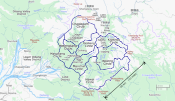
Walong is an administrative town and the headquarters of eponymous circle in the Anjaw district in eastern-most part of Arunachal Pradesh state in India. It also has a small cantonment of the Indian Army. Walong is on banks of Lohit River, which enters India 35 km north of Walong at India-China LAC at Kaho pass.

<span class="mw-page-title-main">Lohit River</span> River in Arunachal Pradesh in India

The Lohit River, which name came from the Assamese word Lohit meaning blood, also known as the Zayul Chu by the Tibetans and Tellu by the Mishmis, is a river in China and India, which joins the Brahmaputra River in the state of Assam. It is formed in the Zayul County of the Tibet Autonomous Region, through a merger of two rivers: the Kangri Karpo Chu, which originates in the Kangri Karpo range, and Zayul Chu, which originates to its northeast. The two rivers merge below the town of Rima. The combined river descends through this mountainous region and surges through Arunachal Pradesh in India for 200 kilometres (120 mi) before entering the plains of Assam where it is known as the Lohit River. Tempestuous and turbulent, and known as the river of blood partly attributable to the lateritic soil, it flows through the Mishmi Hills, to meet the Siang (Brahmaputra) at the head of the Brahmaputra valley.

<span class="mw-page-title-main">Bomê County</span> County in Tibet, Peoples Republic of China

Pome County or Bomê County is a county of Nyingchi Prefecture in the south-east of the Tibet Autonomous Region. Historically known as Powo or Poyul, it was the seat of a quasi-independent kingdom until the early 20th century when troops of the Dalai Lama's Lhasa government integrated it into the central Tibetan realm. The population was 25,897 in 2004.

<span class="mw-page-title-main">Zayu County</span> County in Tibet, Peoples Republic of China

Zayul County (Tibetan: རྫ་ཡུལ་རྫོང, Wylie: rdza yul rdzong, THL: dza yül dzong) or Zayü County is a county in the Nyingchi Prefecture in the southeastern part of the Tibet Autonomous Region, China.

<span class="mw-page-title-main">Anjaw district</span> District of Arunachal Pradesh in India

Anjaw District (Pron:/ˈændʒɔ:/) is an administrative district in the state of Arunachal Pradesh in north-east India. It was created district in 2004, by splitting off from the Lohit district under the Arunachal Pradesh Re-organization of Districts Amendment Act. The district borders China on the north. Hawai, at an altitude of 1296 m above sea level, is the district headquarters, located on the banks of the Lohit River, a tributary of the Brahmaputra River. It is the easternmost district in India. The furthest villages towards the border with China are Dong, Walong, Kibithu and Kaho.

<span class="mw-page-title-main">Simla Convention</span> 1914 treaty concerning the status of Tibet

The Simla Convention, officially the Convention Between Great Britain, China, and Tibet, was an ambiguous treaty concerning the status of Tibet negotiated by representatives of the Republic of China, Tibet and Great Britain in Simla in 1913 and 1914.

South Tibet is a claimed area by China with the literal translation of the Chinese term '藏南', which may refer to different geographic areas:

<span class="mw-page-title-main">Tuting</span> Town in Arunachal Pradesh, India

Tuting is a town and headquarters of an eponymous circle in the Upper Siang district in Arunachal Pradesh, India. It is situated on the bank of Siang river (Brahmaputra) at a distance of 34 km (21 mi) south of Line of Actual Control and 170 km (110 mi) north of Yingkiong. Tuting is the center of an assembly constituency, and also home to an Indian Military headquarters. The border area reports frequent incursion attempts by the Chinese People's Liberation Army, including an attempt to construct a road in Indian territory.

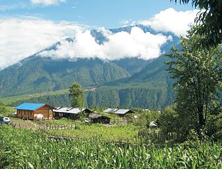
Hayuliang is a town and the headquarters of an eponymous subdivision in the Anjaw district in the north-eastern state of Arunachal Pradesh, India. It is on the bank of the Lohit River near the confluence of the Delei River.

Milakatong La or Menlakathong La is a historic mountain pass along the trade route between Tawang in India's Arunachal Pradesh and Tsona Dzong in Tibet's Shannan province via the valley of Tsona Chu.

Kaho is a small village on the banks of Lohit River at an elevation of 1,240 metres (4,070 ft) on the India-China LAC in Anjaw district of Arunachal Pradesh state in India. It is 580 km east of Itanagar, nearly 70 km north of district headquarter at Hawai, nearly 8 km south of India-China LAC, 30 km west of Diphu Pass near India-China-Myanmar tri-junction, and 10 km north of Kibithu. Nearest air connectivity is 30 km in the south at Walong airstrip in Walong. The village has an Indian Army check-post. Kaho will be projected as the first village of the country by team Discover FarEast with the help of district administration.

Migyitun, also called Tsari or Zhari, is a town in the Lhöntse County of Tibet's Shannan Prefecture. It is on the banks of the Tsari Chu river close to the McMahon Line, the de facto border with India's Arunachal Pradesh. It is also a key part of the Buddhist Tsari pilgrimage, made once in twelve years, that makes a wide circumambulation of the Dakpa Sheri mountain.

<span class="mw-page-title-main">Dakpa Sheri</span> Mountain in Tibet

Dakpa Sheri (Tibetan: དག་པ་ཤེལ་རི, Wylie: dag pa shel ri, THL: dak pa shel ri, Chinese: 达瓜西热; pinyin: Dá guā xī rè), explained as "Pure Crystal Mountain" and also known as Tsari, is a mountain in the eponymously named Tsari region in Lhöntse County of Tibet's Shannan Prefecture. The mountain is considered sacred for Tibetans and the pilgrimage route circumambulates the mountain. Takpa Siri ridge consists of four hills/ passes and four water bodies.

<span class="mw-page-title-main">Rima, Tibet</span> Village in Tibet, Peoples Republic of China

Rima is the former capital of the Zayul in the southeastern Tibet Autonomous Region of China. It is on the border with India's Arunachal Pradesh at the confluence of the Rongto Chu and Zayul Chu rivers, which join to form the Zayul River before it flows into Arunachal Pradesh. Rima was a notable border trading town, which the British contemplated as a location for a trade mart in the Lhasa Convention.

Metengliang is a village and the headquarters of an eponymous circle in the Anjaw district in the north-eastern state of Arunachal Pradesh, India.

Tulung La (Tibetan: ཐུ་ལུང་ལ་, Wylie: thu lung la) is a border pass between the Tsona County in the Tibet region of China and India's Tawang district in Arunachal Pradesh. It is in the eastern part of the two districts, close to the Gori Chen cluster of mountains, on a watershed between the Tsona Chu river in Tibet and the Tawang Chu in the Tawang district. The watershed ridge forms the border between Tibet and India as per the McMahon Line. Tulung La provided an invasion route to China during the 1962 Sino-Indian War. It is also the scene of occasional clashes between the two sides.

References

  1. 1 2 2011 Census of India: Chaglagam
  2. Anjaw District Census Handbook, Part A, Census of India, 2012, p. 20.
  3. Irani Sonowal Lepcha, China’s PLA incursions increasing in Arunachal? More reports emerge, EastMojo, 23 September 2020.
  4. India map wrong in India-China border in Arunachal Pradesh, says area Lok Sabha MP, ETV Bharat, 6 February 2020.
  5. Tapir Gao pleads Centre for redrawing political map to include several places, The Sentinel Assam, 6 February 2020.
  6. Lamb, The McMahon Line, Vol. 2 (1966), p. 356.
  7. Map of Anjaw, Anjaw District website, retrieved 5 July 2021.
  8. Mehra, The McMahon Line and After 1974, p. 224.
  9. Kingdon Ward, The Himalaya East of the Tsangpo (1934), p. 385.
  10. 1 2 Confidential note of the Chief of General Staff in 1912, reproduced in Woodman, Dorothy (1969), Himalayan Frontiers: A Political Review of British, Chinese, Indian, and Russian Rivalries, Praeger, pp. 374–375 via archive.org
  11. "Top officials to meet to expedite road building along China border". NDTV India. Retrieved 27 October 2014.
  12. "Top officials to meet to expedite road building along China border". Dipak Kumar Dash. timesofindia.indiatimes.com. Retrieved 27 October 2014.
  13. "Narendra Modi government to provide funds for restoration of damaged highways". Daily News and Analysis. Retrieved 27 October 2014.
  14. "Indian Government Plans Highway Along Disputed China Border". Ankit Panda. thediplomat.com. Retrieved 27 October 2014.
  15. "Govt planning road along McMohan line in Arunachal Pradesh: Kiren Rijiju". Live Mint. Retrieved 26 October 2014.
  16. "China warns India against paving road in Arunachal". Ajay Banerjee. tribuneindia.com. Retrieved 26 October 2014.

Bibliography