Chester Township, Logan County, Illinois

Last updated
Chester Township
Township
Map highlighting Chester Township, Logan County, Illinois.svg
Location in Logan County
Map of Illinois highlighting Logan County.svg
Logan County's location in Illinois
Country United States
State Illinois
County Logan
EstablishedNovember 7, 1865
Area
  Total38.31 sq mi (99.2 km2)
  Land38.29 sq mi (99.2 km2)
  Water0.02 sq mi (0.05 km2)  0.05%
Population
 (2010)
  Estimate 
(2016) [1]
653
  Density17.5/sq mi (6.8/km2)
Time zone UTC-6 (CST)
  Summer (DST) UTC-5 (CDT)
FIPS code 17-107-13126

Chester Township is located in Logan County, Illinois. As of the 2010 census, its population was 669 and it contained 298 housing units. [2] Chester Township changed its name from Madison Township sometime prior to 1921.

Contents

Geography

According to the 2010 census, the township has a total area of 38.31 square miles (99.2 km2), of which 38.29 square miles (99.2 km2) (or 99.95%) is land and 0.02 square miles (0.052 km2) (or 0.05%) is water. [2]

Demographics

Historical population
CensusPop.
Est. 2016653 [1]
U.S. Decennial Census [3]

Related Research Articles

Caseyville Township, St. Clair County, Illinois Township in Illinois, United States

Caseyville Township is located in St. Clair County, Illinois, United States. As of the 2010 census, its population was 31,996 and it contained 14,054 housing units.

Engelmann Township, St. Clair County, Illinois Township in Illinois, United States

Engelmann Township is located in St. Clair County, Illinois. As of the 2010 census, its population was 726 and it contained 288 housing units.

Mascoutah Township, St. Clair County, Illinois Township in Illinois, United States

Mascoutah Township is located in St. Clair County, Illinois. As of the 2010 census, its population was 8,217 and it contained 3,335 housing units.

Shiloh Valley Township, St. Clair County, Illinois Township in Illinois, United States

Shiloh Valley Township is located in St. Clair County, Illinois. As of the 2010 census, its population was 11,631 and it contained 4,284 housing units. Shiloh Valley Township was originally called Shiloh before its name was changed on an unknown date.

Worth Township, Woodford County, Illinois Township in Illinois, United States

Worth Township is located in Woodford County, Illinois. As of the 2010 census, its population was 8,741 and it contained 3,212 housing units.

Groveland Township, Tazewell County, Illinois Township in Illinois, United States

Groveland Township is located in Tazewell County, Illinois. As of the 2010 census, its population was 19,526 and it contained 8,441 housing units.

Hopedale Township, Tazewell County, Illinois Township in Illinois, United States

Hopedale Township is located in Tazewell County, Illinois. As of the 2010 census, its population was 1,913 and it contained 806 housing units. Hopedale Township changed its name from Highland Township on May 20, 1850.

Little Mackinaw Township, Tazewell County, Illinois Township in Illinois, United States

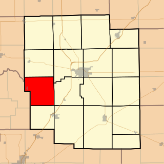
Little Mackinaw Township is located in Tazewell County, Illinois. As of the 2010 census, its population was 1,575 and it contained 678 housing units.

Morton Township, Tazewell County, Illinois Township in Illinois, United States

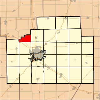
Morton Township is located in Tazewell County, Illinois, at T25N R3W. It is traversed by Interstate Routes 74 and 155, about 15 km (10 mi) southeast of Peoria, Illinois.

Danvers Township, McLean County, Illinois Township in Illinois, United States

Danvers Township is located in McLean County, Illinois. As of the 2010 census, its population was 1,925 and it contained 757 housing units.

Dry Grove Township, McLean County, Illinois Township in Illinois, United States

Dry Grove Township is located in McLean County, Illinois. As of the 2010 census, its population was 1,572 and it contained 618 housing units.

White Oak Township, McLean County, Illinois Township in Illinois, United States

White Oak Township is located in McLean County, Illinois. As of the 2010 census, its population was 899 and it contained 355 housing units.

Corwin Township, Logan County, Illinois Township in Illinois, United States

Corwin Township is located in Logan County, Illinois. As of the 2010 census, its population was 643 and it contained 302 housing units. Corwin Township changed its name from Middletown Township on an unknown date.

West Lincoln Township, Logan County, Illinois Township in Illinois, United States

West Lincoln Township is located in Logan County, Illinois. As of the 2010 census, its population was 7,685 and it contained 3,558 housing units.

Eminence Township, Logan County, Illinois Township in Illinois, United States

Eminence Township is located in Logan County, Illinois. As of the 2010 census, its population was 421 and it contained 186 housing units.

Laenna Township, Logan County, Illinois Township in Illinois, United States

Laenna Township is located in Logan County, Illinois. As of the 2010 census, its population was 584 and it contained 282 housing units.

Ball Township, Sangamon County, Illinois Township in Illinois, United States

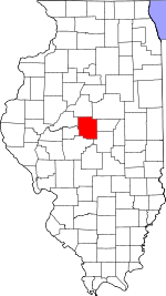
Ball Township is located in Sangamon County, Illinois. As of the 2010 census, its population was 6,701 and it contained 2,403 housing units.

Trivoli Township, Peoria County, Illinois Township in Illinois, United States

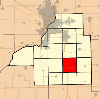
Trivoli Township is located in Peoria County, Illinois. As of the 2010 census, its population was 1,021 and it contained 447 housing units.

Bald Hill Township, Jefferson County, Illinois Township in Illinois, United States

Bald Hill Township is one of sixteen townships in Jefferson County, Illinois, USA. As of the 2010 census, its population was 767 and it contained 359 housing units.

Casner Township, Jefferson County, Illinois Township in Illinois, United States

Casner Township is one of sixteen townships in Jefferson County, Illinois, USA. As of the 2010 census, its population was 1,239 and it contained 510 housing units.

References

  1. 1 2 "Population and Housing Unit Estimates" . Retrieved June 9, 2017.
  2. 1 2 "Population, Housing Units, Area, and Density: 2010 - County -- County Subdivision and Place -- 2010 Census Summary File 1". United States Census. Archived from the original on 2020-02-12. Retrieved 2013-05-28.
  3. "Census of Population and Housing". Census.gov. Retrieved June 4, 2016.

Coordinates: 40°05′34″N89°18′47″W / 40.09278°N 89.31306°W / 40.09278; -89.31306