
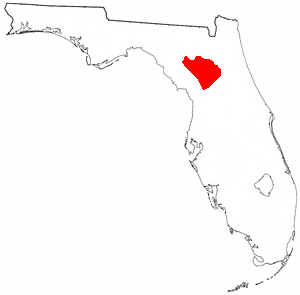
Alachua County is a county in the north central portion of the U.S. state of Florida. As of the 2020 census, the population was 278,468. The county seat is Gainesville, the home of the University of Florida since 1906, when the campus opened with 106 students.

Alachua is the second-largest city in Alachua County, Florida and the third-largest in North Central Florida. According to the 2020 census, the city's population was 10,574. The city is part of the Gainesville metropolitan area, which had a population of 339,247 in 2020.
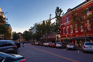
Gainesville is the county seat of Alachua County, Florida, and the largest city in North Central Florida, with a population of 141,085 in 2020. It is the principal city of the Gainesville metropolitan area, which had a population of 339,247 in 2020.

A sinkhole is a depression or hole in the ground caused by some form of collapse of the surface layer. The term is sometimes used to refer to doline, enclosed depressions that are locally also known as vrtače and shakeholes, and to openings where surface water enters into underground passages known as ponor, swallow hole or swallet. A cenote is a type of sinkhole that exposes groundwater underneath. Sink and stream sink are more general terms for sites that drain surface water, possibly by infiltration into sediment or crumbled rock.

Myakka River State Park is a Florida State Park, that is located nine miles (14 km) east of Interstate 75 in Sarasota County and a portion of southeastern Manatee County on the Atlantic coastal plain. This state park consists of 37,000 acres (150 km2), making it one of the state's largest parks. It is also one of the oldest parks in the state. It was delineated in the 1930s by the Civilian Conservation Corps. A small portion of the park was the gift of the family of Bertha Palmer to the state. The park is named after the Myakka River.

Falling Waters State Park is a 171-acre (69 ha) Florida state park located three miles (5 km) south of Chipley, Washington County in northwestern Florida. The park contains a 73-foot (22 m) waterfall, the highest in the state known as "Falling Waters Falls”.

Paynes Prairie Preserve State Park is a Florida State Park, encompassing a 21,000-acre (85 km2) savanna in Alachua County, Florida lying between Micanopy and Gainesville. It is also a U.S. National Natural Landmark. It is crossed by both I-75 and U.S. 441. It is in the center of the Paynes Prairie Basin. The basin's primary source of drainage is Alachua Sink. During occasional wet periods, the basin will become full. A notable period occurred from 1871 to 1891 when the Alachua Sink was temporarily blocked. During this period, shallow draft steamboats were a frequent sight on Alachua Lake in the center of the prairie. The region was also historically known as the Alachua Savannah. Its drainage has been modified by several canals. Since 1927, Camps Canal has linked the basin to the River Styx which leads to Orange Lake and eventually the Atlantic Ocean through the St. Johns River. That reduced the basins water intake by half. Additional changes to the prairie's environment have been detrimental to its hydrology. In 1970, the state of Florida acquired the land and has been in the process of restoring the environment to a more natural condition ever since.

North Central Florida is a region of the U.S. state of Florida which comprises the north-central part of the state and encompasses the North Florida counties of Alachua, Marion, Putnam, Bradford, Columbia, Dixie, Gilchrist, Hamilton, Lafayette, Levy, Madison, Suwannee, Taylor, and Union. The region's largest city is Gainesville, home of the University of Florida and center of the Gainesville metropolitan area, which is the largest metro area in North Central Florida. As of 2020, the region had a population of 575,622 people.

San Felasco Hammock Preserve State Park is a Florida State Park in Alachua County, Florida. It is located northwest of Gainesville, Florida on CR 232, just south of the town of Alachua.
The Alachua culture is a Late Woodland Southeast period archaeological culture in north-central Florida, dating from around 600 to 1700. It is found in an area roughly corresponding to present-day Alachua County, the northern half of Marion County and the western part of Putnam County. It was preceded by the Cades Pond culture, which inhabited approximately the same area.

Newell Hall is a historic site in Gainesville, Florida, United States. It is located in the northeastern section of the University of Florida. On June 27, 1979, it was added to the U.S. National Register of Historic Places. Formerly home to the Department of Soil and Water Science, the building is currently used as a 24/7 study space for university students to collaborate.

Before drainage, the Everglades, a region of tropical wetlands in southern Florida, were an interwoven mesh of marshes and prairies covering 4,000 square miles (10,000 km2). The Everglades is both a vast watershed that has historically extended from Lake Okeechobee 100 miles (160 km) south to Florida Bay, and many interconnected ecosystems within a geographic boundary. It is such a unique meeting of water, land, and climate that the use of either singular or plural to refer to the Everglades is appropriate. When Marjory Stoneman Douglas wrote her definitive description of the region in 1947, she used the metaphor "River of Grass" to explain the blending of water and plant life.

Tropical hardwood hammocks are closed canopy forests, dominated by a diverse assemblage of evergreen and semi-deciduous tree and shrub species, mostly of West Indian origin. Tropical hardwood hammocks are found in South Florida or the Everglades, with large concentrations on the Miami Rock Ridge, in the Florida Keys, along the northern shores of Florida Bay, and in the Pinecrest region of the Big Cypress Swamp.

The South Florida rocklands ecoregion, in the tropical and subtropical moist broadleaf forests biome, occurs in southern Florida and the Florida Keys in the United States, where they would naturally cover an area of 2,100 km2 (810 sq mi). These forests form on limestone outcrops with very thin soil; the higher elevation separating them from other habitats such as coastal marshes and marl prairies. On mainland Florida, rocklands exist primarily on the Miami Rock Ridge, which extends from the Miami River south to Everglades National Park. South Florida rocklands are further divided into pine rocklands and rockland hammocks.

The Southeastern conifer forests are a temperate coniferous forest ecoregion of the southeastern United States. It is the largest conifer forest ecoregion east of the Mississippi River. It is also the southernmost instance of temperate coniferous forest within the Nearctic realm.
Warren's Cave is a dry karst cave in Alachua County, Florida. It is the longest dry cave in Florida, with more than 4 miles (6.4 km) of mapped passages. The cave is located on the margin of the Cody Scarp near the San Felasco Hammock Preserve State Park, northwest of the city of Gainesville. The property on which the entrance to Warren's Cave is located, the Warren Cave Nature Preserve, is owned by the National Speleological Society. Warren's cave was probably formed by a high water table when sea levels in the Quaternary Period were elevated close to 100 feet (30 m) above current sea level, corresponding to the Wicomico terrace.
Hidden Waters Preserve is a nature reserve located on Country Club Road near Eustis, Florida.
Spring Grove, Florida was a settlement in Alachua County, Florida during the territorial period in Florida, serving for three years as the county seat of the county. It was about four miles west of Hogtown, probably in the San Felasco Hammock, west or northwest of present-day Gainesville. Four archaeological sites in the San Felasco Hammock Preserve State Park may have been part of Spring Grove. A post office was established in Spring Grove in 1829. In 1835, a unit of volunteer mounted riflemen called the Spring Grove Guards was organized in Alachua County under authority of the Florida territorial council. Most of the 60 or so members were from Spring Grove and Hogtown. The unit ceased operations in less than a year, after the Second Seminole War began. The territorial council designated Spring Grove as the county seat of Alachua County in February 1836. Three years later, in February 1839, the territorial council moved the county seat to Newnansville. The post office closed sometime in 1848.


