
The Grand Island metropolitan area, as defined by the United States Census Bureau, is an area consisting of four counties in Nebraska, anchored by the city of Grand Island. It was upgraded from a micropolitan area and Hamilton County was added in 2012 when Grand Island's population surpassed 50,000.

The Kearney Micropolitan Statistical Area, as defined by the United States Census Bureau, is an area consisting of two counties in Nebraska, anchored by the city of Kearney.

The North Platte Micropolitan Statistical Area, as defined by the United States Census Bureau, is an area consisting of three counties in Nebraska, anchored by the city of North Platte. As of the 2000 census, the area had a population of 35,939, and a July 1, 2009 estimate placed the population at 36,890.

The Rockford Metropolitan Statistical Area, as defined by the United States Census Bureau, is an area consisting of four counties in north-central Illinois, anchored by the city of Rockford. As of the 2010 census, the MSA had a population of 349,431. The Rockford MSA abuts the southern portions of the Janesville-Beloit MSA and the Chicago MSA. It forms the main part of the larger Rockford–Freeport–Rochelle Combined Statistical Area.
The Ontario Micropolitan Statistical Area, as defined by the United States Census Bureau, is an area consisting of two counties – one in southeastern Oregon and one in southwestern Idaho, anchored by the city of Ontario.

The New Bern Metropolitan Statistical Area, as defined by the United States Census Bureau, is an area consisting of three counties in the Inner Banks region of eastern North Carolina, anchored by the city of New Bern. The designation of the area was changed from Micropolitan to Metropolitan in 2013.

The Roanoke Rapids, NC Micropolitan Statistical Area (μSA) as defined by the United States Census Bureau, is an area consisting of two counties in North Carolina, anchored by the city of Roanoke Rapids.
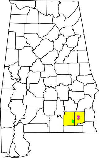
The Enterprise–Ozark Micropolitan Statistical Area, as defined by the United States Census Bureau, was an area consisting of two counties in southeastern Alabama, anchored by the cities of Enterprise and Ozark. As of the 2000 census, the μSA had a population of 92,744.
The Mount Sterling Micropolitan Statistical Area, as defined by the United States Census Bureau, is an area consisting of three counties in Kentucky, anchored by the city of Mount Sterling. As of the 2000 census, the μSA had a population of 40,195.

The Muscatine Micropolitan Statistical Area, as defined by the United States Census Bureau, is an area consisting solely of Muscatine County and anchored by the city of Muscatine. The Muscatine Micropolitan Statistical Area is also a part of the Quad Cities Iowa–Illinois Combined Statistical Area (CSA), which has a population of 474,226, making it the 90th-largest CSA in the nation.

The Salina, Kansas micropolitan area, as defined by the United States Census Bureau, is an area consisting of two counties in Kansas, anchored by the city of Salina.

The Americus micropolitan statistical area, as defined by the United States Census Bureau, is an area consisting of two counties in Georgia, anchored by the city of Americus.

The Waycross Micropolitan Statistical Area (μSA), as defined by the United States Census Bureau, is an area consisting of two counties in Georgia, anchored by the city of Waycross.

The Martinsville Micropolitan Statistical Area is a United States Micropolitan Statistical Area (USA) in Virginia, as defined by the Office of Management and Budget (OMB) as of June, 2003. As of the 2000 census, the μSA had a population of 73,346.

The Dublin Micropolitan Statistical Area, as defined by the United States Census Bureau, is an area consisting of two counties in Georgia, anchored by the city of Dublin.

The Lafayette-West Lafayette, Indiana Metropolitan Statistical Area, as defined by the United States Census Bureau, is an area consisting of three counties in Indiana, anchored by the cities of Lafayette and West Lafayette. As of the July 1, 2021, the MSA had an estimated population of 224,709. Metro area population in 2021 is 237,130 and was 235,066 in 2020, a growth of 16% over 2010. In 2010, the Lafayette, Indiana, metro area population was 210,297.
The Kokomo Metropolitan Statistical Area, as defined by the United States Census Bureau, is an area consisting of Howard County in Indiana. Howard County had a population estimate of 83,831 in 2023. Kokomo is also the principal city of the area known as North Central Indiana, the area around Kokomo with economic ties. The six county area including Cass, Clinton, Fulton, Howard, Miami, and Tipton counties had population of 228,331 people in 2010.

The London, KY Micropolitan Statistical Area is a United States Census Bureau defined Micropolitan Statistical Area located in the vicinity of London, Kentucky. The London Micropolitan Statistical Area encompasses Laurel County entirely. The Micropolitan Statistical Area had a population of 52,715 at the 2000 Census. A July 1, 2009 U.S. Census Bureau estimate placed the population at 57,749.
The Greenville-Washington, NC Combined Statistical Area, as defined by the United States Census Bureau, is an area consisting of seven counties in Eastern North Carolina. As of the 2011 census estimate, the CSA had a population of 427,723, compared to 399,848 in the 2009 census estimate.

The Hilton Head Island metropolitan area, officially the Hilton Head Island–Bluffton–Port Royal, SC Metropolitan Statistical Area as defined by the United States Census Bureau, is a metropolitan statistical area consisting of the two southernmost counties in the Lowcountry region of South Carolina, centered on the resort town of Hilton Head Island. As of the 2020 census, the MSA had a population of 215,908. Prior to March 2013, the region was considered a micropolitan statistical area.
