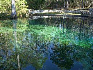
Ponce de Leon Springs State Recreation Area is a Florida State Park in Holmes County, Florida, USA. It is located in the town of Ponce de Leon. The park, which was created to provide public outdoor recreation and other park-related uses, was initially acquired on September 4, 1970, using funds from the Land Acquisition Trust Fund. Its self-proclaimed purpose is to develop, operate and maintain the property for outdoor recreation, park, historic, and related purposes, offering abundant opportunity for nature appreciation and wildlife viewing. Its primary recreational activities include swimming in the spring and hiking along the park's nature trails.

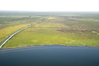
The Arthur R. Marshall Loxahatchee National Wildlife Refuge is a 145,188-acre (587.55 km2) wildlife sanctuary is located west of Boynton Beach, in Palm Beach County, Florida. It is also known as Water Conservation Area 1 (WCA-1). It includes the most northern remnant of the historic Everglades wetland ecosystem.

Cranberry Glades—also known simply as The Glades—are a cluster of five small, boreal-type bogs in southwestern Pocahontas County, West Virginia, United States. This area, in the Allegheny Mountains at about 3,400 feet (1,000 m), is protected as the Cranberry Glades Botanical Area, part of the Monongahela National Forest. This site is the headwaters of the Cranberry River, a popular trout stream, and is adjacent to the nearly 50,000-acre (200 km2) Cranberry Wilderness.
The Alligator River National Wildlife Refuge is a 152,000-acre (620 km2) National Wildlife Refuge located in eastern North Carolina along the Atlantic Coast. It was established on March 14, 1984, to preserve and protect a unique wetland habitat type—the pocosin—and its associated wildlife species.

Tosohatchee Wildlife Management Area is located along the St. Johns River east of Orlando in Christmas on Taylor Creek Road, off SR 50.

The Lake George State Forest is a designated protected area and state forest in the U.S. state of Florida. The 21,176-acre (8,570 ha) forest is located in northwestern Volusia County, Florida, near Lake George and the communities of Pierson, Barberville, and Volusia. It is overseen by the Florida Forest Service within the Florida Department of Agriculture and Consumer Services.

The Florida Fish and Wildlife Conservation Commission (FWC) is a Florida government agency founded in 1999 and headquartered in Tallahassee. It manages and regulates the state's fish and wildlife resources, and enforces related laws. Officers are managers, researchers, and support personnel, and perform law enforcement in the course of their duties.

Colt Creek State Park is a Florida State Park in Central Florida, 16 miles (26 km) north of Lakeland off of State Road 471. This 5,067 acre park nestled within the Green Swamp Wilderness Area and named after one of the tributaries that flows through the property was opened to the public on January 20, 2007. Composed mainly of pine flatwoods, cypress domes and open pasture land, this piece of pristine wilderness is home to many animal species including the American bald eagle, Southern fox squirrel, gopher tortoise, white-tailed deer, wild turkey and bobcat.
The Atchafalaya National Wildlife Refuge is located about 30 miles (48 km) west of Baton Rouge, Louisiana, and one mile (1.6 km) east of Krotz Springs, Louisiana, lies just east of the Atchafalaya River. In 1988 under the administration of Governor Foster the "Atchafalaya Basin Master Plan" was implemented that combined the 11,780-acre (4,770 ha) Sherburne Wildlife Management Area (WMA), the 15,220-acre (6,160 ha) Atchafalaya National Wildlife Refuge, and the 17,000-acre (6,900 ha) U.S. Army Corps of Engineers' Bayou Des Ourses into the Sherburne Complex Wildlife Management Area.

The Florida black bear is a subspecies of the American black bear that has historically ranged throughout most of Florida and the southern portions of Georgia, Alabama, and Mississippi. The large black-furred bears live mainly in forested areas and have seen recent habitat reduction throughout the state due to increased human development, as well as habitat modifications within bear habitat.
Pass a Loutre Wildlife Management Area (WMA) is a 115,000-acre (47,000 ha) protected wetland in Plaquemines Parish, Louisiana, United States. The WMA is located due south and bordering the 48,000 acre Delta National Wildlife Refuge, accessible only by air or boat, contains the Pass A L'Outre Lighthouse, and Port Eads is within the boundary.
Chassahowitzka Wildlife Management Area (WMA) preserves 24,243 acres of sandhill, mesic hammock, and forested wetland habitat ten miles north of Weeki Wachee in Hernando County, Florida. The area consists of one large tract of land, with three satellite tracts nearby.
Portneuf Wildlife Management Area at 3,104 acres (12.56 km2) is an Idaho Wildlife Management Area (WMA) in Bannock County near the town of McCammon. The first land acquisition for the WMA occurred in 1970 from M.S. Bastian, a local farmer and rancher. Three additional parcels were acquired in 1974.

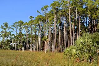
The longleaf pine ecosystem is a temperate coniferous forest ecosystem found within the Southern United States. Spanning pine savannas, sandhills and montane forests, it includes many rare plant and animal species, and is one of the most biodiverse in North America. Once one of the largest ecosystems in North America, from Virginia south to Florida and west to Texas, it now occupies less than a quarter of the original range. Degradation of the ecosystem is partially due to excessive timber harvesting, urbanization, and fire exclusion. Although the ecosystem is heavily fragmented at present, it still carries a great diversity of plant and animal species, many of which are endemic. A range of techniques, including planting longleaf pine seedlings, introducing prescribed burning regimens, managing native ground cover, and controlling invasive species within the ecosystem, are used in attempting to preserve this threatened ecosystem.
Andrews Wildlife Management Area is located on the Suwannee River, five miles north of Chiefland in Levy County, Florida.

Fred C. Babcock/Cecil M. Webb Wildlife Management Area (WMA) is Florida's oldest wildlife management area and protects 80,772 acres (32,687 ha) just southeast of Punta Gorda in Charlotte and Lee Counties, Florida. The area is accessed from its own exit off of Interstate-75.
Apalachicola River Wildlife and Environmental Area (ARWEA) contains 63,257 acres of pine upland, floodplain swamp, savanna, and estuary habitat north of Eastpoint and Apalachicola in Franklin County and Gulf County, Florida.
Okaloacoochee Slough Wildlife Management Area (WMA) protects 2,992 acres of the larger Okaloacoochee Slough ecosystem approximately 30 miles east of Fort Myers in Hendry County, Florida.
Apalachee Wildlife Management Area (WMA) consists of 7,952 acres of upland longleaf pine and wetland habitat three miles north of Sneads in Jackson County, Florida. The area is broken up into three management zones, all located along Lake Seminole and the Chattahoochee River.

Aucilla Wildlife Management Area conserves 50,549 acres of hydric hammock, mesic flatwoods, upland forest, and spring-run river twelve miles southeast of Tallahassee in Jefferson and Taylor Counties in Florida.
