Florida's 7th congressional district

Last updated

Florida's 7th congressional district
Florida's 7th congressional district (since 2023).svg
Florida's 7th congressional district
Interactive map of district boundaries since January 3, 2023
Representative
Area436 [1]  sq mi (1,130 km2)
Distribution
  • 97.87% urban [2]
  • 2.13% rural
Population (2023)802,027 [3]
Median household
income
$76,668 [3]
Ethnicity
Cook PVI R+5 [4]

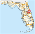
Florida's 7th congressional district is a congressional district in the north central portion of the U.S. state of Florida.

Contents

From 2003 to 2013, the district consisted of the suburban area between Orlando and Daytona Beach and included St. Augustine. The district included all of Flagler and St. Johns Counties; a very small portion of eastern Putnam County; parts of Volusia County, including portions of DeLand, Deltona, Ormond Beach, and Daytona Beach; much of western Seminole County; and a small, predominantly suburban portion of Orange County.

Following court-ordered redistricting in 2015, the district included all of Seminole County and northern Orange County, including much of downtown and northern Orlando and the cities of Maitland and Winter Park. At the time, the district was also home to the University of Central Florida (UCF), the state's largest university by student population in 2020–2021. [5]

Following further redistricting in 2022 based on the 2020 United States census, the 7th district still includes all of Seminole County. It now includes the southern half of Volusia County, while the portion of the district that extended into Orange County, including UCF, is now part of the 10th congressional district.

The district is currently represented in the U.S. Congress by Rep. Cory Mills.

Recent election results from statewide races

YearOfficeResults [6]
2008 President McCain 50% - 49%
2012 President Romney 53% - 47%
2016 President Trump 51% - 44%
Senate Rubio 54% - 41%
2018 Senate Scott 52% - 48%
Governor DeSantis 52% - 47%
Attorney General Moody 55% - 43%
Chief Financial Officer Patronis 54% - 46%
2020 President Trump 52% - 47%
2022 Senate Rubio 57% - 42%
Governor DeSantis 60% - 39%
Attorney General Moody 62% - 38%
Chief Financial Officer Patronis 60% - 40%

Composition

For the 118th and successive Congresses (based on redistricting following the 2020 census), the district contains all or portions of the following counties and communities: [7]

SeminoleCounty (16)

All 16 communities

VolusiaCounty (12)

Daytona Beach Shores, DeBary, Deltona, Edgewater, Glencoe, Lake Helen, New Smyrna Beach, Oak Hill, Orange City, Ponce Inlet, Port Orange, Samsula-Spruce Creek

List of members representing the district

MemberPartyYearsCong
ress
Electoral historyDistrict map
District created January 3, 1953
James A. Haley.jpg
James A. Haley
(Sarasota)
Democratic January 3, 1953 –
January 3, 1973
83rd
84th
85th
86th
87th
88th
89th
90th
91st
92nd
Elected in 1952.
Re-elected in 1954.
Re-elected in 1956.
Re-elected in 1958.
Re-elected in 1960.
Re-elected in 1962.
Re-elected in 1964.
Re-elected in 1966.
Re-elected in 1968.
Re-elected in 1970.
Redistricted to the 8th district .
1953–1973
[ data missing ]
Sam Melville Gibbons.jpg
Sam Gibbons
(Tampa)
Democratic January 3, 1973 –
January 3, 1993
93rd
94th
95th
96th
97th
98th
99th
100th
101st
102nd
Redistricted from the 6th district and re-elected in 1972.
Re-elected in 1974.
Re-elected in 1976.
Re-elected in 1978.
Re-elected in 1980.
Re-elected in 1982.
Re-elected in 1984.
Re-elected in 1986.
Re-elected in 1988.
Re-elected in 1990.
Redistricted to the 11th district .
1973–1993
[ data missing ]
John Mica Portrait.jpg
John Mica
(Winter Park)
Republican January 3, 1993 –
January 3, 2017
103rd
104th
105th
106th
107th
108th
109th
110th
111th
112th
113th
114th
Elected in 1992.
Re-elected in 1994.
Re-elected in 1996.
Re-elected in 1998.
Re-elected in 2000.
Re-elected in 2002.
Re-elected in 2004.
Re-elected in 2006.
Re-elected in 2008.
Re-elected in 2010.
Re-elected in 2012.
Re-elected in 2014.
Lost re-election.
1993–2003
[ data missing ]
2003-2013
FL-7th District-109.gif
2013–2017
Florida US Congressional District 7 (since 2013).tif
Stephanie Murphy official photo.jpg
Stephanie Murphy
(Winter Park)
Democratic January 3, 2017 –
January 3, 2023
115th
116th
117th
Elected in 2016.
Re-elected in 2018.
Re-elected in 2020.
Retired.
2017–2023
FL07 115.png
Representative Cory Mills Cropped Portrait.jpg
Cory Mills
(New Smyrna Beach)
Republican January 3, 2023 –
present
118th
119th
Elected in 2022.
Re-elected in 2024.
2023–present
Florida's 7th congressional district in Orlando (since 2023).svg

Electoral history

2002

Florida's 7th Congressional District Election (2002)
PartyCandidateVotes%
Republican John L. Mica* 142,147 59.58
Democratic Wayne Hogan 96,444 40.42
Total votes238,591 100.00
Republican hold

2004

Florida's 7th Congressional District Election (2004)
PartyCandidateVotes%
Republican John L. Mica* 100.00
Total votes100.00
Republican hold

2006

Florida's 7th Congressional District Election (2006)
PartyCandidateVotes%
Republican John L. Mica* 149,656 59.88
Democratic John F. Chagnon 87,584 36.92
Total votes237,240 100.00
Republican hold

2008

Florida's 7th Congressional District Election (2008)
PartyCandidateVotes%
Republican John L. Mica* 238,721 62.00
Democratic Faye Armitage 146,292 38.00
Total votes385,013 100.00
Republican hold

2010

Florida's 7th Congressional District Election (2010)
PartyCandidateVotes%
Republican John L. Mica* 185,470 69.03
Democratic Heather Beaven83,20630.97
Total votes268,676 100.00
Republican hold

2012

Florida 7th Congressional District 2012
PartyCandidateVotes%
Republican John Mica (Incumbent)185,51858.7
Democratic Jason H. Kenall130,47941.3
Write-inFred Marra130.0
Total votes316,010 100.0
Republican hold

2014

Florida's 7th Congressional District election, 2014
PartyCandidateVotes%
Republican John Mica (Incumbent) 144,474 63.60
Democratic Wes Neuman73,01132.14
No Party AffiliationAl Krulick9,6794.26
Total votes227,164 100.00
Republican hold

2016

Florida's 7th congressional district election, 2016
PartyCandidateVotes%
Democratic Stephanie Murphy 182,039 51.47
Republican John Mica (Incumbent)171,58348.52
No Party AffiliationMike Plaskon330.01
Total votes353,655 100
Democratic gain from Republican

2018

Florida's 7th Congressional District Election, 2018
PartyCandidateVotes%
Democratic Stephanie Murphy (Incumbent) 183,113 57.7
Republican Mike Miller 134,28542.3
Total votes317,398 100.00
Democratic hold

2020

Florida's 7th Congressional District Election, 2020
PartyCandidateVotes%
Democratic Stephanie Murphy (Incumbent) 224,946 55.34
Republican Leo Valentín175,75043.24
No Party AffiliationWilliam Garlington5,7531.42
Total votes406,449 100.00
Democratic hold

2022

Florida's 7th congressional district election, 2022
PartyCandidateVotes%
Republican Cory Mills 177,966 58.53
Democratic Karen Green126,07941.47
Independent Cardon Pompey (write-in)10<0.01
Total votes304,045 100.00
Republican gain from Democratic

Related Research Articles

<span class="mw-page-title-main">Volusia County, Florida</span> County in Florida, United States

Volusia County is a county located in the east-central part of the U.S. state of Florida between the St. Johns River and the Atlantic Ocean. As of the 2020 census, the county was home to 553,543 people, an increase of 11.9% from the 2010 census. It was founded on December 29, 1854, from part of Orange County, and was named for the community of Volusia, located in northwestern Volusia County. Its first county seat was Enterprise. Since 1887, its county seat has been DeLand.

<span class="mw-page-title-main">DeBary, Florida</span> City in Florida, United States

DeBary is a city in Volusia County, Florida, United States, on the eastern shore of the St. Johns River near Lake Monroe. According to the 2020 U.S. Census, the city had a population of 20,696. It is part of the Deltona–Daytona Beach–Ormond Beach, FL metropolitan statistical area, which was home to 553,284 people in 2019.

<span class="mw-page-title-main">Deltona, Florida</span> City in Florida, United States

Deltona is a city in Volusia County, Florida, United States. It is located on the northern shore of Lake Monroe. As of the 2020 census, the city population was 93,692. It is a principal city of the Deltona–Daytona Beach–Ormond Beach metropolitan area, which was home to an estimated 685,344 people in 2021. It is the second largest city in the Greater Orlando combined statistical area.

<span class="mw-page-title-main">Port Orange, Florida</span> City in Florida, United States

Port Orange is a city in Volusia County, Florida, United States. The city is part of the Deltona–Daytona Beach–Ormond Beach metropolitan area. Port Orange is a principal city in the Fun Coast region of the state of Florida. As of the 2020 census, the city had a population of 62,596.

<span class="mw-page-title-main">Greater Orlando</span> Metropolitan statistical area in Florida, United States

The Orlando metropolitan area is an inland metropolitan area in the central region of the U.S. state of Florida. Its principal cities are Orlando, Kissimmee, and Sanford. The U.S. Office of Management and Budget defines it as consisting of the counties of Lake, Orange, Osceola, and Seminole.

<span class="mw-page-title-main">Area codes 407 and 689</span> Area codes for Orlando, Florida

Area codes 407 and 689 are telephone area codes in the North American Numbering Plan (NANP) for the city of Orlando and surrounding areas in the U.S. state of Florida. The numbering plan area (NPA) includes Orange, Osceola and Seminole counties, as well as small portions of Volusia and Lake counties.

<span class="mw-page-title-main">Florida's 6th congressional district</span> U.S. House district for Florida

Florida's 6th congressional district is a congressional district in the U.S. state of Florida. The district is located on the Eastern Florida Coast and stretches from the southern Jacksonville suburbs to South Daytona. It includes the city of Daytona Beach.

Arizona's 1st congressional district is a congressional district located in the U.S. state of Arizona, covering northeastern Maricopa County. Before 2023, geographically, it was the eleventh-largest congressional district in the country and included much of the state outside the Phoenix and Tucson metropolitan areas. From 2013 through 2022, it also included the Navajo Nation, the Hopi reservation, and the Gila River Indian Community, with 25% of the population being Native American. At that time, the district had more Native Americans than any other congressional district in the United States. In the 2022 elections, David Schweikert was elected in the redefined district.

<span class="mw-page-title-main">Florida's 11th congressional district</span> U.S. House district for Florida

Florida's 11th congressional district is a congressional district in the U.S. state of Florida. It includes Sumter County, home to The Villages, and parts of Lake, Orange, and Polk counties. In the 2020 redistricting cycle, the district was moved out of its coastal counties and into Orlando's western suburbs.

<span class="mw-page-title-main">Florida's 9th congressional district</span> U.S. House district for Florida

Florida's 9th congressional district is a congressional district in the U.S. state of Florida. It stretches from eastern Orlando south-southeast to Yeehaw Junction. It also includes the cities of Kissimmee and St. Cloud.

<span class="mw-page-title-main">Florida's 10th congressional district</span> U.S. House district for Florida

Florida's 10th congressional district is a congressional district in the U.S. state of Florida. It was reassigned in 2012, effective January 3, 2013, from the Gulf Coast to inland Central Florida. Before 2017, the district included parts of western Orange County, most of Lake County, as well as a northern section of Polk County. The current district is entirely within Orange County, and covers most of its western portion. It is situated along the Interstate 4 corridor. It includes most of the western half of Orlando. Other cities and towns wholly or partly within the district include Apopka, Belle Isle, Beulah, Eatonville, Harlem Heights, Ocoee, Oak Ridge, Orlo Vista, Winter Garden, and Windermere. In 2020, the district was expanded further north and south to include most of Orlando east of Interstate 4, the Baldwin Park area, Orlando Executive Airport, Winter Park, that portion of Maitland within Orange County, the Azaela Park, Goldenrod, Rio Pinar and Alafaya/Waterford Lakes areas, and continuing east to the University of Central Florida, Naval Support Activity Orlando, the Central Florida Research Park, and the Lake Pickett, Bithlo and Wedgefield areas. Even with this expansion, the 10th remains a minority majority district.

<span class="mw-page-title-main">Florida's 13th congressional district</span> U.S. House district for Florida

Florida's 13th congressional district is an electoral district for the U.S. Congress on Florida's Gulf Coast, assigned to Pinellas County. The district includes Largo, Clearwater, and Palm Harbor. In the 2020 redistricting cycle, most of St. Petersburg facing Tampa Bay was redistricted into the 14th district, while the rest of Pinellas County formerly in the 12th district became included in the 13th district.

<span class="mw-page-title-main">Deltona–Daytona Beach–Ormond Beach, Florida Metropolitan Statistical Area</span> Metropolitan statistical area in Florida, United States

The Deltona–Daytona Beach–Ormond Beach, Florida Metropolitan Statistical Area is a metropolitan statistical area (MSA) in central and the north portions of Florida consisting of Volusia and Flagler counties in the state of Florida. As of 2023, it is the 83rd-largest MSA in the United States, with a census-estimated population of 721,796.

<span class="mw-page-title-main">Florida's 5th congressional district</span> U.S. House district for Florida

Florida's 5th congressional district is a congressional district in the U.S. state of Florida. It includes the southeastern area of Jacksonville which comprises areas such as Arlington, East Arlington, Southside, Mandarin, San Jose, and the Beaches. It stretches south to St. Augustine in St. Johns County.

<span class="mw-page-title-main">Florida's 24th congressional district</span> U.S. House district for Florida

Florida's 24th congressional district is an electoral district for the U.S. Congress, located in southeast Florida. It was redrawn after the 2020 U.S. census. This district includes parts of Miami north of Florida State Road 112, including Little Haiti, as well as Brownsville, Biscayne Park, North Miami, Miami Gardens, and Opa Locka, along with the southern Broward County communities of Pembroke Park, West Park, and parts of Miramar. In the 2020 redistricting cycle, the district was drawn to include parts of barrier islands northeast of Miami, including Miami Beach and Surfside, while all of Hollywood became part of the new 25th district as Country Club and some of Miami, including Allapattah and Wynwood, became part of the new 26th district.

<span class="mw-page-title-main">Florida's 8th congressional district</span> U.S. House district for Florida

Florida's 8th congressional district is an electoral district for the U.S. Congress and was reassigned in 2012, effective January 2013, from the inland central part of Florida to the central Atlantic coast. The district includes Titusville, Melbourne, Cocoa, and Cape Canaveral, Florida. The district includes all of Brevard County, as well as all of Indian River County and parts of Orange County. The district also includes the Kennedy Space Center.

<span class="mw-page-title-main">Florida's 3rd congressional district</span> U.S. House district for Florida

Florida's 3rd congressional district is an electoral district of the United States House of Representatives located in Florida. It presently comprises a large section of north central Florida, including the entire counties of Alachua, Baker, Bradford, Columbia, Dixie, Gilchrist, Hamilton, Levy, Suwannee, and Union, along with the majority of Lafayette and Marion County. The city of Gainesville is in the district as well as part of Ocala, and portions of the Jacksonville metropolitan area.

<span class="mw-page-title-main">Florida's 4th congressional district</span> U.S. House district for Florida

Florida's 4th congressional district is a congressional district in northeastern Florida, encompassing Nassau and Clay counties and Duval County west of the St. Johns River, including Downtown Jacksonville. The district is currently represented by Aaron Bean of the Republican Party.

<span class="mw-page-title-main">Florida's 19th congressional district</span> U.S. House district for Florida

Florida's 19th congressional district is a U.S. congressional district in Southwest Florida. It includes the cities of Cape Coral, Fort Myers, Fort Myers Beach, Sanibel, Bonita Springs, Naples and Marco Island, as well as unincorporated areas in Lee and Collier counties. It has been represented by Republican Byron Donalds since 2021.

<span class="mw-page-title-main">Florida's 18th congressional district</span> U.S. House district for Florida

Florida's 18th congressional district is an electoral district for the U.S. Congress, located in the Florida Heartland. In the 2020 redistricting cycle, the district was redrawn to cover inland counties of DeSoto, Glades, Hardee, Hendry, Highlands, and Okeechobee, as well as most of Polk County and some of Immokalee in Collier County. It is essentially the successor to the old 15th district. The district is currently represented by Republican Scott Franklin.

References

  1. "Congressional Plan--SC14-1905 (Ordered by The Florida Supreme Court, 2-December-2015)" (PDF). Florida Senate Committee on Reapportionment. Retrieved January 11, 2017.
  2. "Congressional Districts Relationship Files (State-based)". U.S. Census Bureau. Archived from the original on April 2, 2013. Retrieved February 7, 2018.
  3. 1 2 "My Congressional District".
  4. "2022 Cook PVI: District Map and List". Cook Political Report. July 12, 2022. Retrieved January 10, 2023.
  5. "UCF Facts 2020-2021 | University of Central Florida - Orlando, FL". University of Central Florida. Retrieved March 21, 2021.
  6. https://davesredistricting.org/maps#viewmap::3a6791b9-a186-4691-a95c-5d51dbb3be1c
  7. https://www2.census.gov/geo/maps/cong_dist/cd118/cd_based/ST12/CD118_FL07.pdf

28°43′33″N81°13′11″W / 28.72583°N 81.21972°W / 28.72583; -81.21972