Biratnagar is a metropolitan city in Nepal, which serves as the capital of Koshi Province. With a population of 242,548 as per the 2011 census, it is the largest city in the province and also the headquarters of Morang district. As per the preliminary report of 2021 Nepal census, Biratnagar has an estimated city population of 244,750. It is the administrative center of the Greater Birat Development Area which incorporates the cities of Biratnagar-Itahari-Gothgau-Biratchowk-Dharan primarily located on the Koshi Highway in Eastern Nepal, with an estimated total urban agglomerated population of 804,300 people living in 159,332 households. Biratnagar is located 399 km (248 mi) east of the capital, Kathmandu, and 6 km (3.7 mi) north of the bordering town of Jogbani in the Indian state of Bihar.

Darbhanga is the fifth largest city and municipal corporation in the state of Bihar in India, and is considered an important city in North Bihar. It serves as the headquarters of the Darbhanga district and the Darbhanga division. It is held that the name Darbhanga has been derived from Dwar Banga or Dari – Banga, meaning the 'door of Bengal'.
Araria is a city and a municipality that is the headquarters of Araria district in the Indian state of Bihar. Araria is situated in the northern part of Bihar.

Purnia is the fourth largest city of Bihar and is emerging as the biggest economic hub in North Bihar. It serves as the administrative headquarters of both Purnia district and Purnia division in the Indian state of Bihar. It is well known for its favourable climate like Darjeeling and has an abundance of resources for human settlements and economic activities.
Supaul is a town and a municipality that is headquarters of Supaul district in the Indian state of Bihar. Supaul is the administrative headquarters of this district. There Are 11 block under the Supaul district Supaul,Kishanpur,Saraigarh-Bhaptiyahi,Pipra,Triveniganj,Raghopur,chhatapur,Nirmali,Marauna,Basantpur and pratapganj.

Sitamarhi is one of the districts in the Mithila region of the Indian state of Bihar, India. Dumra is the administrative headquarters of this district. The district is a part of the Tirhut Division and is located along the border of Nepal.

Jay Prakash Narayan Airport is a International airport serving Patna, the capital of Bihar, India. It is named after the independence activist and political leader, Jayprakash Narayan. It is the 15th busiest airport in India. To meet demand, the Airports Authority of India (AAI) is working to expand and modernise airport infrastructure. The airport is currently undergoing an ambitious expansion project that includes a new two-level passenger terminal, which will be completed by December 2023.

Birpur is a city and a notified area in Supaul district in the state of Bihar, India. It is a small town on the Indo-Nepal border near the historic Koshi Barrage on the Koshi River. It has an airstrip, which is being modernised and later on will be utilized for commercial as well defence use. It had been made when first prime minister of India Jawaharlal Nehru had landed here to lay the foundation stone of Koshi Barrage. There has been a new helipad constructed next to the airstrip for multi purpose use.

Forbesganj is a city with municipality in the Araria District in the state of Bihar, India, situated at the border of Nepal.

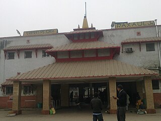
Raxaul is a sub-divisional town in the East Champaran district of the Indian state of Bihar. It is situated at the India-Nepal border with Birgunj city (Nepal). Raxaul is a major railway junction.

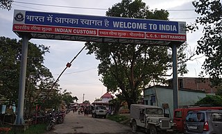
Jogbani is a Village, a notified area in Araria District of Bihar state, India. It lies on the Indo-Nepal border with Morang District, Koshi Zone and is a gateway to Biratnagar city. There is a customs checkpoint for goods at the border. Indian and Nepalese nationals cross without restrictions.
Nirmali is a town and a notified area in Supaul district in the Indian state of Bihar.

Airforce Station Purnea is located in Purnia in the state of Bihar, India. This is the base of Indian Air Force. This airport was built for supplies to Indian Army in Sino-Indian War. This airbase is used as backup in the region of North East Corridor.

Itahari is a sub-metropolitan city in the Sunsari District of Koshi Province of Nepal. Itahari city is the business hub of eastern Nepal. It is the second most populous city in Eastern Nepal after Biratnagar. Situated at a distance of 25 kilometres north of the provincial capital of Biratnagar, 16 kilometres south of Dharan and 92 kilometres west of Kakarbhitta, Itahari serves as a junction point of the east-west Mahendra Highway and the north–south Koshi Highway. Itahari has an estimated city population of 1,98,098 living in 40,207 households as per 2021 Nepal census. It is one of the fastest growing cities of Eastern Nepal. It is one of the cities of the Greater Birat Development Area which incorporates the cities of Biratnagar-Itahari-Gothgau-Biratchowk-Dharan primarily located on the Koshi Highway in Eastern Nepal, with an estimated total urban agglomerated population of 804,300 people living in 159,332 households.
Shahbazpur, also known as Khurd-Dhanpura, is a village located in Araria district of the Indian state of Bihar. This village is located near the border of India and Nepal.
Moti Babu Institute of Technology, Forbesganj - MBIT has been established with a view to impart technical and professional education in the periphery of Forbesganj in Araria district. MBIT is situated in area of 18 acres in the Rampur village, Araria district and is 300 km from Patna.It is also very near to Nepal's second largest city Biratnagar (10 km). Bihar Industrial Area Development Authority(Biada) was instrumental in allotting land in Araria district. Inaugurated on 22 July 2013, MBIT is affiliated with Aryabhatta Knowledge University, Patna, Moti Babu Institute of Technology is the brainchild of Amit Kumar Das, a NRI billionaire from Bihar, who currently resides in Sydney. A number of national and international agencies have been instrumental in assisting MBIT to create an academic alliance with TAFE, South Australia. MBIT foundation stone was laid in 2010.MBIT was named after Amit Kumar Das’ father, Moti Lal Das, lovingly called 'Moti Babu'.

Jaynagar railway station is a main terminal railway station in Madhubani district, Bihar. Its code is JYG. It serves Jainagar and the surrounding areas. The station consists of 5 platforms.

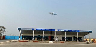
Darbhanga Airport is a domestic airport and an Indian Air Force Station, serving Darbhanga, Bihar, India. It is located just at the outskirts of the city near the NH-105 and NH-57 highways, which passes through Darbhanga. The airport is operated by the Airports Authority of India (AAI). The foundation stone for the airport was laid by the then Chief Minister of Bihar, Nitish Kumar, and the then Civil Aviation Minister, Suresh Prabhu, in the presence of the State Civil Aviation Minister, Jayant Sinha, on 24 December 2018. After efforts taken by the MP of Darbhanga, Gopal Jee Thakur, and the then Civil Aviation Minister, Hardeep Singh Puri. Commercial flights started on 8 November 2020.

Department of Railways under Ministry of Physical Infrastructure and Transport is the authority to develop, maintain and plan railways in Nepal. It has its headquarter at Bishalnagar, Kathmandu. Currently it maintains three in-operation railway lines in the country: Raxaul–Sirsiya,Jainagar–Bhangaha and Bathnaha - Budhnagar. It is equivalent to Department of Road for road infrastructure. It has several lines been planned.

Shrikhandi Bhittha or Bhitthamore is an Indian village in the Mithila region of Bihar, situated near the Indo-Nepal border, on the banks of the perennial Ratnawati (Raato) river.


