Fort Lowell

Last updated
Fort Lowell
Tucson, Arizona

Tucson-Fort Lowell Hospital-1878.JPG

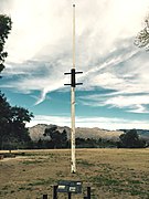
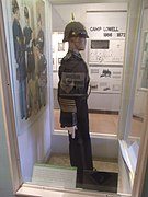
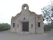
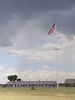
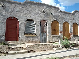
Ruins of the hospital at Old Fort Lowell, Tucson.
Type Army fortification
Site information
Controlled byFlag of Arizona.svg  Arizona
Condition tourist attraction
Site history
Built 1873
Built byFlag of the United States (1867-1877).svg  United States
In use 1873 - 1891
Materials adobe, mesquite, earth
Battles/wars Apache Wars
Garrison information
Occupants Flag of the United States (1891-1896).svg United States Army

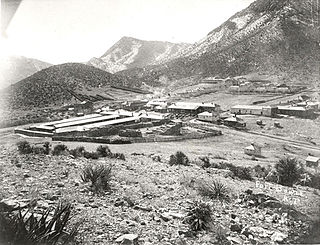
Fort Lowell was a United States Army post active from 1873 to 1891 on the outskirts of Tucson, Arizona. Fort Lowell was the successor to Camp Lowell, an earlier Army installation. [1] The Army chose a location just south of the confluence of the Tanque Verde and Pantano creeks, at the point where they form the Rialto River, due to the year-round supply of water during that period. The Hohokam natives had chosen the site centuries earlier, presumably for the same reason. To this day, shards of Hohokam pottery can still be found in the area. The Army claimed a military reservation that encompassed approximately eighty square miles and extended east toward the Rincon Mountains. [2]

United States Army Land warfare branch of the United States Armed Forces

The United States Army (USA) is the land warfare service branch of the United States Armed Forces. It is one of the seven uniformed services of the United States, and is designated as the Army of the United States in the United States Constitution. As the oldest and most senior branch of the U.S. military in order of precedence, the modern U.S. Army has its roots in the Continental Army, which was formed to fight the American Revolutionary War (1775–1783)—before the United States of America was established as a country. After the Revolutionary War, the Congress of the Confederation created the United States Army on 3 June 1784 to replace the disbanded Continental Army. The United States Army considers itself descended from the Continental Army, and dates its institutional inception from the origin of that armed force in 1775.

Tucson, Arizona City in Arizona, United States

Tucson is a city and the county seat of Pima County, Arizona, United States, and home to the University of Arizona. The 2010 United States Census put the population at 520,116, while the 2015 estimated population of the entire Tucson metropolitan statistical area (MSA) was 980,263. The Tucson MSA forms part of the larger Tucson-Nogales combined statistical area (CSA), with a total population of 1,010,025 as of the 2010 Census. Tucson is the second-largest populated city in Arizona behind Phoenix, both of which anchor the Arizona Sun Corridor. The city is 108 miles (174 km) southeast of Phoenix and 60 mi (97 km) north of the U.S.–Mexico border. Tucson is the 33rd largest city and the 58th largest metropolitan area in the United States (2014).

Arizona state of the United States of America

Arizona is a state in the southwestern region of the United States. It is also part of the Western and the Mountain states. It is the sixth largest and the 14th most populous of the 50 states. Its capital and largest city is Phoenix. Arizona shares the Four Corners region with Utah, Colorado, and New Mexico; its other neighboring states are Nevada and California to the west and the Mexican states of Sonora and Baja California to the south and southwest.

Contents

History

The Post of Tucson was established May 20, 1862, after the California Column drove Confederate forces from the area. The post was abandoned in July 1864 and reestablished in July 1865. On August 29, 1866 the post was renamed Camp Lowell in honor of General Charles Russell Lowell, who died from wounds sustained during the Battle of Cedar Creek. Initially located on the east side of Sixth Avenue, between Twelfth and Fourteenth Streets, the post was moved for sanitary reasons to a location about 7 miles (11 km) east of town on March 31, 1873. The post's name was changed to Fort Lowell on April 5, 1879. [3]

California Column

The California Column was a force of Union volunteers sent to Arizona and New Mexico during the American Civil War. The command marched over 900 miles from California through Arizona and New Mexico Territory to the Rio Grande and as far east as El Paso, Texas, between April and August 1862.

Confederate States Army Army of the Confederate States

The Confederate States Army (C.S.A.) was the military land force of the Confederate States of America (Confederacy) during the American Civil War (1861–1865), fighting against the United States forces. On February 28, 1861, the Provisional Confederate Congress established a provisional volunteer army and gave control over military operations and authority for mustering state forces and volunteers to the newly chosen Confederate president, Jefferson Davis. Davis was a graduate of the U.S. Military Academy, and colonel of a volunteer regiment during the Mexican–American War. He had also been a United States Senator from Mississippi and U.S. Secretary of War under President Franklin Pierce. On March 1, 1861, on behalf of the Confederate government, Davis assumed control of the military situation at Charleston, South Carolina, where South Carolina state militia besieged Fort Sumter in Charleston harbor, held by a small U.S. Army garrison. By March 1861, the Provisional Confederate Congress expanded the provisional forces and established a more permanent Confederate States Army.

Charles Russell Lowell Union Army general

Charles Russell Lowell III was a railroad executive, foundryman, and General in the Union Army during the American Civil War. He was mortally wounded at the Battle of Cedar Creek and was mourned by a number of leading generals.

Old West Era

The fort played a pivotal role during the Apache Wars, providing additional protection for the Tucson area. Far too large and well-manned to be attacked directly, Fort Lowell provided supplies and manpower for outlying military installations. During its eighteen years of operation, the fort averaged thirteen officers and 239 enlisted men. Among the units present during this period were the 2nd, 4th, 5th and 6th Cavalry Regiments, as well as the 1st, 8th, and 12th Infantry Regiments. [1]

Apache Wars armed conflicts between indigenous peoples and white people in southwestern USA between 1849 and circa 1924

The Apache Wars were a series of armed conflicts between the United States Army and various Apache nations fought in the southwest between 1849 and 1886, though minor hostilities continued until as late as 1924. The United States inherited conflicts between American invaders and Apache groups when Mexico ceded territory after the Mexican–American War in 1846. These conflicts continued as new United States citizens came into traditional Apache lands to raise livestock, crops and to mine minerals.

2nd Cavalry Regiment (United States) unit of the U.S. Army

The 2nd Cavalry Regiment, also known as the 2nd Dragoons, is an active Stryker infantry and cavalry regiment of the United States Army. The Second Cavalry Regiment is a unit of the United States Army Europe, with its garrison at the Rose Barracks in Vilseck, Germany. It can trace its lineage back to the early part of the 19th century.

4th Cavalry Regiment (United States)

The 4th Cavalry Regiment is a United States Army cavalry regiment, whose lineage is traced back to the mid-19th century. It was one of the most effective units of the Army against American Indians on the Texas frontier. Today, the regiment exists as separate squadrons within the U.S. Army. The 1st Squadron of the 4th Cavalry's official nickname is "Quarterhorse", which alludes to its 1/4 Cav designation. The 3rd Squadron of the 4th Cavalry's official nickname is "Raiders". Today, the "1st Squadron, 4th Cavalry", "2nd Squadron, 4th Cavalry", "4th Squadron, 4th Cavalry", and "6th Squadron, 4th Cavalry" are parts of the 1st Infantry Division, while the "3rd Squadron, 4th Cavalry" serves as part of the 25th Infantry Division. On 23 September 2009, the "4th Squadron, 4th Cavalry" officially stood up at Fort Riley, Kansas as part of the 1st "Devil" Brigade, 1st Infantry Division. On 28 March 2008, the "5th Squadron, 4th Cavalry" officially stood up at Fort Riley, Kansas as part of the 2nd "Dagger" Brigade, 1st Infantry Division. The 6th Squadron, 4th Cavalry served as part of the recently inactivated 1st Infantry Division, 3rd "Duke" Brigade, at Fort Knox, Kentucky.

The orientation of the post was set according to magnetic north. It featured a large parade grounds, officers' quarters, quartermaster and commissary storehouses, corrals, quarters for enlisted men as well as for married non-commissioned officers. The most prominent building on post was the hospital, the adobe remnants of which still stand under a protective structure. A lane lined with cottonwood trees, aptly named Cottonwood Lane, graced the area in front of the officers' houses.

Quartermaster army supply officer or naval rank

Quartermaster is a military or naval term, the meaning of which depends on the country and service. In land armies, a quartermaster is generally a relatively senior soldier who supervises stores and distributes supplies and provisions. In many navies, a quartermaster is a non-commissioned officer rank; in some others, it is not a rank but a role related to navigation.

A commissary is a government official charged with oversight or an ecclesiastical official who exercises in special circumstances the jurisdiction of a bishop.

An enlisted rank is, in some armed services, any rank below that of a commissioned officer. The term can be inclusive of non-commissioned officers or warrant officers, except in United States military usage where warrant officers/chief warrant officers are a separate officer category ranking above enlisted grades and below commissioned officer grades. In most cases, enlisted service personnel perform jobs specific to their own occupational specialty, as opposed to the more generalized command responsibilities of commissioned officers. The term "enlistment" refers solely to a military commitment whereas the terms "taken of strength" and "struck off strength" refer to a servicemember being carried on a given unit's roll.

Among the more well known officers to have served at Fort Lowell were the young Walter Reed, the Army physician famous for his yellow fever research, and Charles Bendire, the amateur ornithologist after whom Bendire's thrasher is named.

Walter Reed American physician and medical researcher

Major Walter Reed, M.D., U.S. Army, was a U.S. Army physician who in 1901 led the team that postulated and confirmed the theory that yellow fever is transmitted by a particular mosquito species, rather than by direct contact. This insight gave impetus to the new fields of epidemiology and biomedicine, and most immediately allowed the resumption and completion of work on the Panama Canal (1904–1914) by the United States. Reed followed work started by Carlos Finlay and directed by George Miller Sternberg who has been called the "first U.S. bacteriologist".

Physician professional who practices medicine

A physician, medical practitioner, medical doctor, or simply doctor, is a professional who practises medicine, which is concerned with promoting, maintaining, or restoring health through the study, diagnosis, prognosis and treatment of disease, injury, and other physical and mental impairments. Physicians may focus their practice on certain disease categories, types of patients, and methods of treatment—known as specialities—or they may assume responsibility for the provision of continuing and comprehensive medical care to individuals, families, and communities—known as general practice. Medical practice properly requires both a detailed knowledge of the academic disciplines, such as anatomy and physiology, underlying diseases and their treatment—the science of medicine—and also a decent competence in its applied practice—the art or craft of medicine.

Yellow fever viral disease

Yellow fever is a viral disease of typically short duration. In most cases, symptoms include fever, chills, loss of appetite, nausea, muscle pains particularly in the back, and headaches. Symptoms typically improve within five days. In about 15% of people, within a day of improving the fever comes back, abdominal pain occurs, and liver damage begins causing yellow skin. If this occurs, the risk of bleeding and kidney problems is also increased.

After the Army decommissioned the post in 1891, Mexican families from Sonora soon moved north to take advantage of the free housing. This occupation has become known as the El Fuerte Period. [4]

Mexico country in the southern portion of North America

Mexico, officially the United Mexican States, is a country in the southern portion of North America. It is bordered to the north by the United States; to the south and west by the Pacific Ocean; to the southeast by Guatemala, Belize, and the Caribbean Sea; and to the east by the Gulf of Mexico. Covering almost 2,000,000 square kilometres (770,000 sq mi), the nation is the fifth largest country in the Americas by total area and the 13th largest independent state in the world. With an estimated population of over 120 million people, the country is the eleventh most populous state and the most populous Spanish-speaking state in the world, while being the second most populous nation in Latin America after Brazil. Mexico is a federation comprising 31 states and Mexico City, a special federal entity that is also the capital city and its most populous city. Other metropolises in the state include Guadalajara, Monterrey, Puebla, Toluca, Tijuana and León.

Sonora State of Mexico

Sonora, officially Estado Libre y Soberano de Sonora, is one of 31 states that, with Mexico City, comprise the 32 federal entities of United Mexican States. It is divided into 72 municipalities; the capital city is Hermosillo. Sonora is bordered by the states of Chihuahua to the east, Baja California to the northwest and Sinaloa to the south. To the north, it shares the U.S.–Mexico border with the states of Arizona and New Mexico, and on the west has a significant share of the coastline of the Gulf of California.

Fort Lowell Art Colony

In the 1930s Nan, Pete and Charles Bolsius rebuilt the crumbling adobe ruin of the Post Traders Store making it their home and studio. Thought the 1940s a number other artists moved into the Fort Lowell area establishing a burgeoning artist colony. Significant artists and intellectuals built homes and lived in the area included: René Cheruy and Germaine Cheruy, Win Ellis, modernist painter Jack Maul, sculptor and designer Giorgio Belloli, Charles Bode, architectural designer Veronica Hughart, anthropologists Edward H. Spicer and Rosamond Spicer, photographer Hazel Larson Archer and weaver Ruth Brown. The artist colony attracted writers and poets including beat generation Alan Harrington and Jack Kerouac whose visit is documented in his iconic book On the Road.

Resident Artist and Writers (20th Century)

Fort Lowell and the Boy Scouts of Tucson

"The Boy Scouts had a long connection to Fort Lowell," explained columnist David Leighton, in the Arizona Daily Star newspaper on Feb. 5, 2017:

The first known visit to the old fort ruins by the Boy Scouts of Tucson, which had been established the year before, occurred in April 1912. The scouts marched out to the abandoned fort under the direction of a member of the University of Arizona’s military cadet program. During the week-long encampment the boys did a lot of drilling like soldiers but also were given some free time to search for Native American relics.

A couple years later, the Fort Lowell Boy Scouts troop, which was formed from boys in the neighborhood that had grown up around the old Ft. Lowell ruins, called El Fuerte and a farming community, populated by Mormons, farther west that came to be named Binghamton. The two troops played a baseball game that year and are believed to have used the area fairly regularly for campouts, target practice etc. until about 1921, when Camp Lawton opened on Mount Lemmon. Within a few years, the Boy Scouts of Tucson became part of the Catalina Council of the Boy Scouts of America.

As the years passed, the old fort traded hands a few times, at one point being under the control of the Arizona State Museum of the University of Arizona.

In 1945, with the assistance of prominent local rancher Carlos Ronstadt, the Boy Scouts bid and obtained 40 acres of the old ruins while preventing the land from falling into the hands of developers, who were rumored to have plans of constructing a subdivision where the ruins existed.

A water system was put in place by the Boy Scouts and volunteers and three structures were acquired and donated to the site. One of the structures was used as the Ft. Lowell Training Center and another structure as the Ranger Station. In 1953, the scouts obtained the funds to have a roof built over the remains of the post hospital that still exists today, constructed a rail fence around the hospital ruins which was later replaced by a chain link fence and put up a flagpole just to the south of the remains.

While many successful scout events took place there, by 1957 it was realized that the Boy Scouts didn't have enough money to maintain the site and sold it to Pima County that year. [5]

Fort Lowell Park

Fort Lowell Park

Tucson-Fort Lowell Park Museum.JPG

Fort Lowell Park Museum
Location 2900 North Craycroft Road, Tucson, Arizona
Area 20 acres (8.1 ha)
Built 1878
NRHP reference # 78003358
Added to NRHP 1978 [6]

The fort lay in ruins for many years and many of its adobe structures went into disrepair. Some of the portions of the fort were sold to the families in Tucson. Among the families which acquired in 1928, large portions where the fort was situated was the Adkins family. The Adkins family established a steel tank manufacturing business on the site. In 2006, the family handed over the site (known as the Adkins Parcel) to the City of Tucson. In 2009, the city in association with Pima County created a Master Plan for the creation and development of what was to become the Fort Lowell Park. [7] The park features ball fields, tennis and racquetball courts, a large public swimming pool, and the Fort Lowell Museum dedicated to Fort Lowell's days as an active military installation. Fort Lowell also includes a large pond.

Tucson recently purchased the former Adkins property immediately west of Craycroft Road on which the last of the original officers' quarters stand. Plans indicated that they would be open to the public as a museum. However, high levels of lead paint were found and the buildings were not opened. On the north end of the former Adkins parcel stands a pile of large stones that, according to local lore, formed a wall of the guardhouse in which Geronimo was kept prior to his removal from Arizona.

The Fort Lowell Museum is a branch museum of the Arizona Historical Society, and is located in the reconstructed Commanding Officer's quarters. Exhibits focus on military life on the Arizona frontier. The Fort Lowell Historic District is the neighborhood located on or near Fort Lowell. It is set aside as a historic district.

Fort Lowell is the historical setting of the 1957-1958 syndicated Western television series, Boots and Saddles , starring John Pickard, Patrick McVey, and Gardner McKay.

A reconstructed Fort Lowell was featured in the 1972 film Ulzana's Raid , starring Burt Lancaster. However, the reconstructed fort was actually built in an area just southwest of the Santa Rita Mountains, near Nogales, Arizona.

National Register of Historic Places

Fort Lowell Park and the ruins within the property were listed in the National Register of Historic Places in December 13, 1978. The NRHP number assigned is #78003358. The other properties, which belong to the park or which in the past belonged to Fort Lowell, that are individually listed in National Register of Historic Places are the following: [8]

The following are photographs of structures and plaques located in Fort Lowell Park.

Fort Lowell
Entrance to Fort Lowell Park Tucson-Fort Lowell Park 1873-1891.JPG
Entrance to Fort Lowell Park
Entrance to Fort Lowell Park 
Statue of cavalry soldier at Fort Lowell Park. Fort-lowell-bugler.jpg
Statue of cavalry soldier at Fort Lowell Park.
Statue of cavalry soldier at Fort Lowell Park. 
Ruins of the post hospital. Post-hospital-fort-lowell.JPG
Ruins of the post hospital.
Ruins of the post hospital. 
Ruins of the post kitchen Tucson-Fort Lowel adobe ruins of the kitchen-1878.jpg
Ruins of the post kitchen
Ruins of the post kitchen 
The adobe ruins of the band quarters Tucson-Fort Lowel adobe ruins of the band quarters-1878.jpg
The adobe ruins of the band quarters
The adobe ruins of the band quarters 
The third reconstructed flagstaff in Fort Lowell Tucson-Fort Lowels third reconstructed flagstaff-2007.jpg
The third reconstructed flagstaff in Fort Lowell
The third reconstructed flagstaff in Fort Lowell 
The adobe ruins of one of two soldier barracks Tucson-Fort Lowel ruins of one of two soldier barracks-1878-2.jpg
The adobe ruins of one of two soldier barracks
The adobe ruins of one of two soldier barracks 
The Fort Lowell Museum. Fort-lowell-museum.JPG
The Fort Lowell Museum.
The Fort Lowell Museum. 
Display of a sergeants uniform in the Fort Lowell Park Museum which once belonged to a member of the 5th Cavalry. Tucson-Fort Lowell Park Museum display of a Sgts. uniform.JPG
Display of a sergeants uniform in the Fort Lowell Park Museum which once belonged to a member of the 5th Cavalry.
Display of a sergeants uniform in the Fort Lowell Park Museum which once belonged to a member of the 5th Cavalry. 
Reconstruction of Commanding Officer's Kitchen Tucson-Fort Lowell Park Kitchen.JPG
Reconstruction of Commanding Officer's Kitchen
Reconstruction of Commanding Officer's Kitchen 
The Officer's Quarter's Tucson-Fort Lowell Officer's Quarter's-1873.JPG
The Officer's Quarter's
The Officer's Quarter's 
The Quartermaster's Quarters Tucson-Fort Lowell Quartermaster's Quarter-1873.JPG
The Quartermaster's Quarters
The Quartermaster's Quarters 
The Fort Lowell Post Traders Store and "Riallito House" located at 5425 E. Fort Lowell Rd. Tucson-Fort Lowell Post Traders Store-1875.JPG
The Fort Lowell Post Traders Store and "Riallito House" located at 5425 E. Fort Lowell Rd.
The Fort Lowell Post Traders Store and "Riallito House" located at 5425 E. Fort Lowell Rd. 
The Fort Lowell Quartermaster's Storehouse located at 5479 E. Fort Lowell Rd. Tucson-Fort Lowell Quartermaster's Storehouse-1875.JPG
The Fort Lowell Quartermaster's Storehouse located at 5479 E. Fort Lowell Rd.
The Fort Lowell Quartermaster's Storehouse located at 5479 E. Fort Lowell Rd. 
The San Pedro Chapel, also known as the San Pedro de Fort Lowell (St. Peter's at Fort Lowell Mission). Tucson-San Pedro Chapel-1932.JPG
The San Pedro Chapel, also known as the San Pedro de Fort Lowell (St. Peter's at Fort Lowell Mission).
The San Pedro Chapel, also known as the San Pedro de Fort Lowell (St. Peter's at Fort Lowell Mission). 
Second part of the previous plaque. Post-hospital-2.jpg
Second part of the previous plaque.
Second part of the previous plaque. 
First part of the interpretive plaque to the west of the post hospital. Post-hospital-3.jpg
First part of the interpretive plaque to the west of the post hospital.
First part of the interpretive plaque to the west of the post hospital. 
Second part of the previous plaque. Post-hospital-4.jpg
Second part of the previous plaque.
Second part of the previous plaque. 
First part of the infantry barracks interpretive plaque. Infantry-barracks-1.jpg
First part of the infantry barracks interpretive plaque.
First part of the infantry barracks interpretive plaque. 
Middle part of the previous plaque. Infantry-barracks-2.jpg
Middle part of the previous plaque.
Middle part of the previous plaque. 
Right half of the previous plaque. Infantry-barracks-3.jpg
Right half of the previous plaque.
Right half of the previous plaque. 
Left half of Quartermaster information board. Quartermaster-depot-1.jpg
Left half of Quartermaster information board.
Left half of Quartermaster information board. 
Right half of Quartermaster information board. Quartermaster-depot-2.jpg
Right half of Quartermaster information board.
Right half of Quartermaster information board. 
Information board detailing statue. Trumpeteer.jpg
Information board detailing statue.
Information board detailing statue. 
Information board on officers' quarters. Officers-quarters.jpg
Information board on officers' quarters.
Information board on officers' quarters. 
The San Pedro Chapel National Register of Historic Places Marker. Tucson-San Pedro Chapel National Register of Historic Places Marker.JPG
The San Pedro Chapel National Register of Historic Places Marker.
The San Pedro Chapel National Register of Historic Places Marker. 

See also

Related Research Articles

Lowell Observatory astronomical observatory

Lowell Observatory is an astronomical observatory in Flagstaff, Arizona, United States. Lowell Observatory was established in 1894, placing it among the oldest observatories in the United States, and was designated a National Historic Landmark in 1965. In 2011, the Observatory was named one of "The World's 100 Most Important Places" by TIME. It was at the Lowell Observatory that the dwarf planet Pluto was discovered in 1930 by Clyde Tombaugh.

Tanque Verde, Arizona CDP in Arizona, United States

Tanque Verde is a suburban census-designated place (CDP) in Pima County, Arizona, United States, northeast of Tucson. The population was 16,195 at the 2000 census.

Camp Verde, Arizona Town in Arizona, United States

Camp Verde is a town in Yavapai County, Arizona, United States. As of the 2010 census, the population of the town is 10,873.

Fort Larned National Historic Site

Fort Larned National Historic Site preserves Fort Larned which operated from 1859 to 1878. It is approximately 5.5 miles (8.9 km) west of Larned, Kansas, United States.

Arizona Historical Society organization

The Arizona Historical Society (AHS) is a non-profit organization whose goal is to collect, preserve, interpret, and disseminate the history of Arizona, the West, and Northern Mexico as it pertains to Arizona. It does this through 4 regional divisions. Each division has a representative museum. The statewide divisions are as follows: Southern Arizona Division in Tucson, the Central Arizona Division in Tempe, the Northern Arizona Division in Flagstaff, and the Rio Colorado Division in Yuma. It was founded in 1884.

Fort Bowie historic fort in Arizona, USA

Fort Bowie was a 19th-century outpost of the United States Army located in southeastern Arizona near the present day town of Willcox, Arizona. The remaining buildings and site are now protected as Fort Bowie National Historic Site.

Tubac Presidio State Historic Park state historic park

Tubac Presidio State Historic Park, located in Tubac, Arizona, USA, preserves the ruins of the Presidio San Ignacio de Tubac and various other buildings, thereby presenting a timeline of human settlement in this Southern Arizona town. The park contains a museum, a number of historic sites, an underground archeology exhibit displaying the excavated foundations of the Tubac Presidio, and a picnic area. Various cultural events are held on-site throughout the year, including Anza Days (October), Los Tubaqueños living history presentations, archeological tours, and nature walks. Until recently, the park was administered by Arizona State Parks and was the first park in the Arizona state park system. As a result of budget cutbacks, the Tubac Presidio was scheduled to be closed in 2010, but was rescued by local residents and the Tubac Historical Society. It is now operated by The Friends of the Presidio and staffed with dedicated volunteers.

Mission Los Santos Ángeles de Guevavi

Mission Los Santos Ángeles de Guevavi was founded by Jesuit missionary Fathers Kino and Salvatierra in 1691 as La Misión de San Gabriel de Guevavi, a district headquarters in what is now Arizona, near Tumacácori. Subsequent missionaries called it San Rafael and San Miguel, resulting in the common historical name of Los Santos Ángeles de Guevavi.

Mission San Cayetano de Calabazas place in Arizona listed on National Register of Historic Places

Mission San Cayetano de Calabazas, also known as Calabasas, is a Spanish Mission in the Sonoran Desert, located near present-day near Tumacácori, Arizona.

Fort Totten State Historic Site state park in North Dakota, USA

Fort Totten State Historic Site is a historic site in Fort Totten, North Dakota.

Charles Bolsius Dutch American painter

Charles William Bolsius was born in 's-Hertogenbosch, the Netherlands on 23 June 1907. He studied art formally in Europe moving to New Mexico in the early 1930s. He settled in Tucson in 1934. In that year he was painting, printing, building, and hand carving fine furniture and doors.

National Register of Historic Places listings in Pima County, Arizona Wikimedia list article

This is a list of the National Register of Historic Places listings in Pima County, Arizona.

Yuma Quartermaster Depot State Historic Park

Yuma Quartermaster Depot State Historic Park, formerly Yuma Crossing State Historic Park, and now one of the Yuma Crossing and Associated Sites on the National Register of Historic Places in the Yuma Crossing National Heritage Area. It is an Arizona state park in the city of Yuma, Arizona, USA.

San Pedro Chapel

The San Pedro Chapel is a historic chapel that was built in 1932 at 5230 E. Ft. Lowell Rd. in Tucson, Arizona. It replaced a chapel built in 1915 that was destroyed by a tornado in 1929.

The following is a timeline of the history of the city of Tucson, Arizona, USA.

Barrio Libre human settlement in United States of America

Barrio Libre is a neighborhood in Tucson, Arizona notable for its existence as a relatively unchanged 19th-century Hispanic neighborhood of close-packed row houses. Houses in the barrio are typically adobe with very plain detailing, reflecting the area's history as a district of townhouses for Mexican ranching families. The district includes more than 200 contributing structures, with relatively few non-conforming buildings. The district is bounded by 14th and 18th streets to the north and south, and by Stone and Osborne to the east and west. Meyer Avenue runs through the center of the barrio.

Madame Germaine Rouget Cheruy was a French costume designer, artist and intellectual who moved to the United States in 1924. She launched and taught art programs in private schools in Connecticut including the Loomis Chaffee School in Windsor, Connecticut. In 1939 she moved to Tucson, Arizona and in the early 1940s purchased a home with her husband Rene Cheury in the artist colony of old Fort Lowell. She lived happily with her husband in Arizona. She was recognized and best known for wash drawing, etching, woodblocks, painting, costume design, weaving, fiber arts and arts education.

Annie Verona "Veronica" Barry Hughart (1907-1977) was artist, architectural designer and journalist who lived in Tucson, Arizona and was an active part of the Old Fort Lowell art colony.

References

Coordinates: 32°15′36″N110°52′26″W / 32.26000°N 110.87389°W / 32.26000; -110.87389