
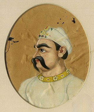
Suraj Mal was a Jat ruler of Bharatpur in present-day state of Rajasthan. Under him, the Jat rule covered the present-day districts of Agra, Aligarh, Bharatpur, Dholpur, Alwar Etawa, Hathras, Mainpuri, Meerut, Ghaziabad, Mathura, and Rohtak, Sonipat, Rewari, Jhajjar, Gurugram, Nuh, Palwal, Faridabad, Kasganj, Mainpuri, Firozabad, Bulandshahr.

Mewat is a historical and cultural region which encompasses parts of the modern-day states of Haryana, Rajasthan, and Uttar Pradesh in north-western India.
The Meo people are an ethnic group from the Mewat region of north-western India.
Churaman was a Jat chieftain of Sinsini, Rajasthan. He became leader of the Jats after Rajaram's death. Bahadur Shah I made him a mansabdar after he supported him against Muhammad Azam Shah in becoming the emperor. He was also made the faujdar of Mathura, and the imperial highway from Delhi to Agra was placed under his protection by the Mughal Emperor.

Gurgaon district, officially known as Gurugram district, is one of the 22 districts of Haryana in northern India. The city of Gurgaon is the administrative headquarters of the district. The population is 1,514,432. It is one of the southern districts of Haryana. On its north, it is bounded by the district of Jhajjar and the Union Territory of Delhi. Faridabad district lies to its east. To its south lie the districts of Palwal and Nuh. To the west lies Rewari district.

Mewati is an Indo-Aryan language spoken predominantly by the Meo people. It has three million speakers in the Mewat Region. While other people groups in the region also speak the Mewati language, it is one of the defining characteristics of the Meo culture.

Nuh district is one of the 22 districts in the Indian state of Haryana. There are four sub-divisions in this district: Nuh, Ferozepur Jhirka, Punahana, and Taoru. The district is known for having the largest Muslim population in Haryana.

Ferozepur Jhirka is a town in the Nuh district of the Indian state of Haryana. It was founded by the ruler of Mewat State, Khanzada Feroz Khan.

Ballabgarh, officially Balramgarh, is a large town, nearby Faridabad city and a tehsil (subdistrict) in Faridabad district of Haryana, India, and is part of the National Capital Region. The town was founded by Raja Balram Singh, in 1739, who also built the Nahar Singh Mahal palace in the same year. Raja Nahar Singh (1823–1858) was the last king of the princely state. He was executed for taking part in the 1857 war of independence in 1858. The town of Ballabhgarh is only 17 miles (27 km) from Delhi, and today lies on the National Highway 19, a major portion of historical Grand Trunk Road. It is connected to Faridabad and south-east Delhi by the Delhi Metro. Ballabhgarh is the fourth city in Haryana to get metro connectivity after Gurgaon, Faridabad and Bahadurgarh.

Nuh(Hindi/Urdu pronunciation: [nũːɦ]) is a city in the Indian state of Haryana. It is the administrative headquarter of the Nuh sub-division in Nuh district of Haryana and lies within in the National Capital Region of India.
Tijara is a city and a municipality in Khairthal-Tijara district of the Indian state of Rajasthan. Tijara comes under the NCR area and is situated 55 km to the northeast of Alwar. The nearest railway station to Tijara is Khairthal. Bhiwadi is a census town in Tijara. It is the biggest industrial area of Rajasthan and part of the historical Ahirwal Mewat region. Tijara is dominated by Yadav and Meo community.

Haryana, formed on 1 November 1966, is a state in North India. For the administrative purpose, Haryana is divided into 6 revenue divisions which are further divided into 22 districts. For Law and Order maintenance, it is divided into 5 Police Ranges and 4 Police Commissionerates.

Palwal district was created on 15 August 2008. It is the 21st district of Haryana state in northern India. Palwal City is the headquarters of the district. It is part of the Braj region.

Bharatpur State, which is also known as the Jat State of Bharatpur historically known as the Kingdom of Bharatpur, was a Hindu Kingdom in the northern part of the Indian subcontinent. It was ruled by the Sinsinwar clan of the Hindu Jats. At the time of reign of king Suraj Mal (1755–1763) revenue of the state was 17,500,000 rupees per annual.
Tourism in Haryana relates to tourism in the state of Haryana, India. There are 21 tourism hubs created by Haryana Tourism Corporation (HTC), which are located in Ambala, Bhiwani Faridabad, Fatehabad, Gurgaon, Hisar, Jhajjar, Jind, Kaithal, Karnal, Kurukshetra, Panchkula, Sirsa, Sonipat, Panipat, Rewari, Rohtak, Yamunanagar, Palwal and Mahendergarh.
Ghasera Fort is a ruined fort in Ghasera village in Nuh district of Haryana state in northern India, which has been notified as a protected monument by the state government. Currently, the majority of the residents of the village are Muslim Meos, though Hindus also live there.
The Badgujar / Bargujar / Badgurjar is a clan of Rajputs. They are also a distinct caste in Maharashtra.
Bhadas is a village, near Nuh city in Nuh District of Haryana state of India. It lies in the Mewat region of Delhi NCR and Delhi–Mumbai Industrial Corridor. It is located on the MDR135 to Hathin-Palwal and is also adjacent to the Delhi Mumbai Expressway. It is 20 km from the Ferozepur Jhirka subdivision and 20 km from the Nuh city, district headquarter, 100 km far from national capital New Delhi and 355 km from state capital Chandigarh. It falls on the southern border of Haryana, near Alwar and Bharatpur Districts of Rajasthan. This lies in one of the most backward areas of the nation.

Ballabhgarh estate, historically known as Ballabgarh estate was a jagir or estate in Haryana, India, ruled by Jats of Tewatia clan. It was founded by Jat king Raja Gopal Tewatia on 1705.

Chaudhary Mohammad Yasin Khan was an Indian politician, social reformer and a prominent leader in the Mewat region of India.


