Jennersville, Pennsylvania | |
---|---|
Unincorporated community | |
Coordinates: 39°49′23″N75°52′11″W / 39.82306°N 75.86972°W | |
Country | United States |
State | Pennsylvania |
County | Chester |
Township | Penn |
Elevation | 581 ft (177 m) |
Time zone | UTC-5 (Eastern (EST)) |
• Summer (DST) | UTC-4 (EDT) |
ZIP code | 19390 |
Area code(s) | 610 and 484 |
GNIS feature ID | 1203138 [1] |
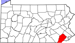
Jennersville is an unincorporated community that is located in Penn Township, Chester County, Pennsylvania, United States at latitude 39.823 and longitude -75.87. [2] It is associated, for postal purposes, with the borough of West Grove, and appears on the West Grove U.S. Geological Survey Map.
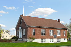
The Jennersville Church of the Brethren [3] and a 105,000-square-foot shopping center are located in Jennersville. Developers of the shopping center have estimated that 10,500 people live within three miles of the center, 23,800 within five miles, and 44,000 within seven miles, based on 2000 U.S. Census data. [4]
Delaware County Community College provides classes at the Pennocks Bridge Campus through a partnership with the Chester County Intermediate Unit.
The Jennersville Hospital closed on December 31, 2021. [5] [6]
The town's elevation is 577 feet (176 m). [2]
Chester County is a county in the Commonwealth of Pennsylvania. It is located in the Delaware Valley region, located in the southeastern part of the state. As of the 2020 census, the population was 534,413, increasing by 7.1% from 498,886 in 2010. The county seat and most populated municipality is West Chester. Chester County was one of the three original Pennsylvania counties created by William Penn in 1682. It was named for Chester, England.
Claymont is a census-designated place (CDP) in New Castle County, Delaware. The estimated 2017 population of the 19703 ZIP code, which Claymont encompasses, was 15,292.
Kiskiminetas Township is a township in Armstrong County, Pennsylvania, United States. The population was 4,604 at the 2020 census, a decrease from the figure of 4,800 tabulated in 2010, making it the most populous township or borough in the county.
North Buffalo Township is a township in Armstrong County, Pennsylvania, United States. The population was 2,698 at the 2020 census, a decrease from the figure of 3,011 tabulated in 2010.
Caln Township is a township in Chester County, Pennsylvania, United States. The population was 14,428 at the 2020 census. The township was founded by settlers from Calne, Wiltshire in England in 1714; the relationship between Calne and Wiltshire continues in the present since the two are sister cities. Caln is a township of the First Class, and the governing body is a Board of Commissioners. The township also owns Ingleside Golf Club and over 200 acres (0.81 km2) of green space and parks. There are 53 employees, including 20 police officers, that work for Caln Township.
Coatesville is a city in Chester County, Pennsylvania, United States. The population was 13,350 at the 2020 census. Coatesville is approximately 39 miles west of Philadelphia. It developed along the Philadelphia and Lancaster Turnpike beginning in the late 18th century. It spans U.S. Route 30, the "Main Line" highway that runs west of Philadelphia.
Exton is a census-designated place (CDP) in West Whiteland Township in Chester County, Pennsylvania, United States. Its population was 5,622 at the 2020 census. The Exton Square Mall and Main Street at Exton are both located within Exton along with several other shopping centers, making Exton the major shopping district in Chester County.
West Chester is a borough and the county seat of Chester County, Pennsylvania, United States. Located within the Philadelphia metropolitan area, the borough had a population of 18,461 at the 2010 census. West Chester is the mailing address for most of its neighboring townships. When calculated by mailing address, the population as of the 2010 U.S. Census was 108,696, which would make it the 10th largest city by mailing address in the state of Pennsylvania.
West Grove is a borough in Chester County, Pennsylvania, United States. The population was 2,775 at the 2020 census.
King of Prussia is a census-designated place in Upper Merion Township in Montgomery County, Pennsylvania, United States. As of the 2020 census, its population was 22,028.
Brethren is an unincorporated community and census-designated place (CDP) in the U.S. state of Michigan. The community is located within Dickson Township, Manistee County, and is in the Northern Lower Peninsula of Michigan. The community had a population of 331 at the 2020 census, down from 410 in 2010. The community is located in the Manistee National Forest, 18 miles (29 km) northeast of Manistee. Brethren has a post office with ZIP code 49619.
Berlin is an unincorporated community and census-designated place in central Berlin Township, Holmes County, Ohio, United States. As of the 2020 census it had a population of 1,447. Located in Ohio's Amish Country, the village is part of a large regional tourism industry.
Kirkwood is an unincorporated farming town and census-designated place (CDP) in Colerain Township, Lancaster County, Pennsylvania, United States. It is part of the Lancaster Metro area, in Pennsylvania Dutch Country. The ZIP code is 17536. As of the 2010 census, the population was 396.
Fivepointville is an unincorporated community and census-designated place (CDP) in Brecknock Township, Lancaster County, Pennsylvania, United States. As of the 2010 census, the population was 1,156. The town is named for its position at an intersection of five separate roads.
Chestertown is a hamlet of the Town of Chester, in Warren County, New York, United States. It is located by the junction of Route 8 and U.S. Route 9, in the Adirondack Mountains. The population was 677 at the 2010 census, which lists the community as a census-designated place.
Johnsville is an unincorporated community in Frederick County, Maryland, United States. It is located approximately halfway between Libertytown and Union Bridge along Maryland Route 75. The Kitterman-Buckey Farm was listed on the National Register of Historic Places in 2005.
Dilley is an unincorporated community in Washington County, Oregon, United States. It is located south of Forest Grove and north of the city of Gaston on Oregon Route 47 in the Portland metropolitan area. Settled in the late 1840s, the community was platted in 1874 after the arrival of the railroad. The population of the area in 2000 was approximately 2,000.
Findley Lake is part of the town of Mina in southwestern Chautauqua County, New York, United States. Situated at an elevation of 1440 ft above sea level, this hamlet is located on the north shore of Findley Lake.
Lilly Chapel is an unincorporated community in Fairfield Township, Madison County, Ohio, United States. It is located at 39°53′20″N83°16′54″W, at the intersection of W. Jefferson Kiousville Road and Lilly Chapel Georgesville Road, approximately three miles west of Georgesville.
London Grove is an unincorporated community in West Marlborough Township in Chester County, Pennsylvania, United States. London Grove is located at the intersection of Pennsylvania Route 926 and Newark Road, north of Avondale. There was a blacksmith shop and a general store, now the parking lot for an apartment building.