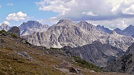
Gannett Peak is the highest mountain peak in the U.S. state of Wyoming at 13,810 feet (4,210 m). It lies in the Wind River Range within the Bridger Wilderness of the Bridger-Teton National Forest. Straddling the Continental Divide along the boundary between Fremont and Sublette counties, it has the second greatest topographic prominence in the state (7076') after Cloud Peak (7077'), and is the highest ground for 290.36 miles in any direction.

Fremont Peak is the third highest peak in the state of Wyoming, surpassed only by Gannett Peak and Grand Teton, and straddles the boundary between Fremont and Sublette counties in the Wind River Range. It is named for American explorer John C. Frémont who climbed the peak with Charles Preuss and Johnny Janisse from August 13 to August 15, 1842. Kit Carson had been with the climbing party on its first attempt at the peak, but had gone back for supplies the day Fremont and his men reached the summit. Carson is thought by some to have been the first to climb neighboring Jackson Peak. At that time, Fremont Peak was mistakenly thought to be the highest mountain in the Rocky Mountains, although there are actually over 100 higher peaks in the Rocky Mountain range.

Mount Warren is located in the Wind River Range in the U.S. state of Wyoming. The peak is the third peak in the range and the fourth tallest in Wyoming. The summit is located in the Fitzpatrick Wilderness of Shoshone National Forest and rises above several glaciers, the best known being Dinwoody Glacier which is immediately north of the summit tower. The mountain abuts, but is not within, either Bridger National Forest or Sublette County, Wyoming.

Mount Woodrow Wilson is located in the Wind River Range in the U.S. state of Wyoming. Mount Woodrow Wilson is the eighth-highest mountain in the range and the ninth-highest in Wyoming. The summit is located in the Bridger Wilderness of Bridger-Teton National Forest on the Continental Divide, 1.25 miles (2.01 km) south of Gannett Peak. The flanks of the mountain are covered in snowfields and glaciers, including Dinwoody Glacier to the northeast, Mammoth Glacier to the west and Sphinx Glacier to the south.

Flagstone Peak is located in the Wind River Range in the U.S. state of Wyoming. The peak is the 12th highest peak in Wyoming. The summit is located on the Continental Divide and is in both Shoshone and Bridger-Teton National Forests. The Flagstone Peak-Southeast Peak lies .25 mi (0.40 km) to the southeast.

Klondike Peak is located in the northern Wind River Range in the U.S. state of Wyoming. Situated 4 mi (6.4 km) north of Gannett Peak, Klondike Peak is within the Bridger Wilderness of Bridger-Teton National Forest and west of the Continental Divide. The summit of Klondike Peak is partially capped by a small glacier and the northwest flank of the peak is the origination point of J Glacier, while Sourdough Glacier lies just to the northeast. Klondike Peak is the 26th tallest peak in Wyoming.
Bastion Peak-Northeast Peak 13,476 ft (4,107 m) is located in the Wind River Range in the U.S. state of Wyoming. The peak is one of the highest in Wyoming, and is connected to its taller neighbor Bastion Peak by an arête to the southwest. An unnamed glacier lies below the precipitous east flank of the mountain, while Gannett Glacier is to the south.

Raid Peak is located in the Wind River Range in the U.S. state of Wyoming. The mountain is in the Bridger Wilderness of Bridger-Teton National Forest, 1.25 mi (2.01 km) west of the Continental Divide and .85 mi (1.37 km) south of Mount Bonneville. The east face of Raid Peak has one of the most spectacular cliff faces in the Wind River Range, rising almost 2,000 ft (610 m) above an unnamed lake with 1,700 ft (520 m) of that being a nearly sheer wall which is rated at class 5.8 and Grade IV-V. Most ascents up this face take at least a day if not two days.

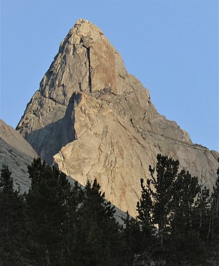
Mount Hooker is located in the Wind River Range in the U.S. state of Wyoming. Mount Hooker was named for Joseph Dalton Hooker, the prominent 19th-century British botanist and explorer. The north and east slopes of Mount Hooker present some of the tallest and steepest vertical cliffs in Wyoming, and the peak is also remote, being more than 20 mi (32 km) from a road. The formidable 1,800-foot (550 m) north face of Mount Hooker was first climbed in 1964 by Yosemite Valley climber Royal Robbins, along with Dick McCracken and Charlie Raymond, who took over three days to scale the cliff face. In 2013, a team free climbed one pitch rated at class 5.14a, grade VI during a multiple-day ascent requiring five other pitches rated above 5.12.

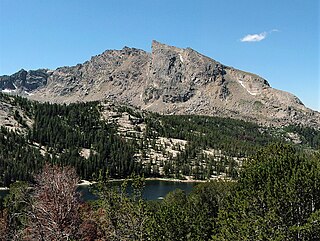
Squaretop Mountain is an 11,695-foot-elevation (3,565-meter) mountain summit located in Sublette County of Wyoming, United States.

White Rock is a cliff with an 11,284-foot-elevation (3,439-meter) summit located in Sublette County of Wyoming, United States.

Haystack Mountain is an 11,978-foot-elevation (3,651-meter) mountain summit located in Sublette County of Wyoming, United States.
Schiestler Peak is an 11,624-foot-elevation (3,543-meter) mountain summit located in Sublette County of Wyoming, United States.
Steeple Peak is a 12,040-foot-elevation (3,670-meter) summit located in Sublette County of Wyoming, United States.

Spider Peak is a 12,234-foot-elevation (3,729-meter) mountain summit located in Fremont County of Wyoming, United States.

Mount Lester is a 12,342-foot-elevation (3,762-meter) mountain summit located in Sublette County, Wyoming, United States.

Bollinger Peak is a 12,232-foot-elevation (3,728-meter) mountain summit located on the shared border of Sublette County and Fremont County in the state of Wyoming, United States.

Mount Geikie is a 12,378-foot-elevation (3,773-meter) mountain summit in Sublette County, Wyoming, United States.

Hobbs Peak is an 11,663-foot-elevation (3,555-meter) mountain summit in Fremont County, Wyoming, United States.

Roberts Mountain is a 12,774-foot-elevation (3,894-meter) summit in Fremont County, Wyoming, United States.