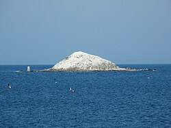
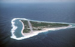
The extreme points of Japan include the coordinates that are the farthest north, south, east and west in Japan, and the ones that are at the highest and the lowest elevations in the country. Japan's northernmost point is disputed, because Japan considers it to be on Iturup, an island de facto governed by Russia. The southernmost point is Okinotorishima; the westernmost is Cape Irizaki on Yonaguni Island in Okinawa Prefecture, and the easternmost is Minami Torishima. The highest point in Japan is the summit of Mount Fuji at 3,776.24 m (12,389 ft). At 150 m (492 ft) below sea level, the bottom of Hachinohe mine is the country's lowest point. The surface of Hachirōgata is Japan's lowest natural point at 4 m (13 ft) below sea level. With the exception of Cape Irizaki, the westernmost location of Japan, all other extreme locations are uninhabited.
Japan extends from 20° to 45° north latitude (Okinotorishima to Benten-jima) and from 122° to 153° east longitude (Yonaguni to Minami Torishima). [1] The coordinates used in this article are sourced from Google Earth, which makes use of the World Geodetic System (WGS) 84.
The northernmost point that Japan claims lies on the disputed island of Iturup. Japan's claim to the three southernmost islands of the Kuril Islands is disputed by Russia, which de facto controls the islands. This list provides the northernmost point as claimed by Japan as well as the northernmost undisputed point in Japan.
Heading | Location | Prefecture | Bordering entity | Coordinates † | Ref |
---|---|---|---|---|---|
North (disputed) | Cape Kamoiwakka | Hokkaido ‡ | Sea of Okhotsk | 45°33′26″N148°45′09″E / 45.55722°N 148.75250°E | [2] |
North (undisputed) | Benten-jima | Hokkaidō | La Pérouse Strait | 45°31′38″N141°55′06″E / 45.52722°N 141.91833°E | [3] |
South | Okinotorishima | Tokyo | Philippine Sea | 20°25′31″N136°04′11″E / 20.42528°N 136.06972°E | |
East | Minami Torishima | Tokyo | Pacific Ocean | 24°16′59″N153°59′11″E / 24.28306°N 153.98639°E | |
West | Yonaguni | Okinawa | East China Sea | 24°26′58″N122°56′01″E / 24.44944°N 122.93361°E | Monument of Japan the westernmost |
The five main islands of Japan are Honshū, Hokkaidō, Shikoku, Kyūshū and Okinawa. [4] All of these points are accessible to the public.
Heading | Location | Prefecture | Bordering entity | Coordinates † | Ref |
---|---|---|---|---|---|
North | Cape Sōya | Hokkaidō | La Pérouse Strait | 45°31′22″N141°56′11″E / 45.52278°N 141.93639°E | |
South | Cape Takanasaki | Okinawa | East China Sea | 26°04′30″N127°40′51″E / 26.07500°N 127.68083°E | |
East | Cape Nosappu | Hokkaidō | Pacific Ocean | 43°23′06″N145°49′03″E / 43.38500°N 145.81750°E | |
West | Cape Irizaki | Okinawa | East China Sea | 26°11′55″N127°38′11″E / 26.19861°N 127.63639°E |
Heading | Location | Prefecture | Bordering entity | Coordinates † | Ref |
---|---|---|---|---|---|
North | Cape Sōya | Hokkaidō | La Pérouse Strait | 45°31′22″N141°56′11″E / 45.52278°N 141.93639°E | |
South | Cape Shirakami | Hokkaidō | Tsugaru Strait | 41°23′51″N140°11′51″E / 41.39750°N 140.19750°E | |
East | Cape Nosappu | Hokkaidō | Pacific Ocean | 43°23′06″N145°49′03″E / 43.38500°N 145.81750°E | |
West | Cape Obana | Hokkaidō | Sea of Japan | 42°18′11″N139°46′01″E / 42.30306°N 139.76694°E |
Heading | Location | Prefecture | Bordering entity | Coordinates † | Ref |
---|---|---|---|---|---|
North | Cape Takei | Kagawa | Bungo Channel | 34°24′01″N134°08′12″E / 34.40028°N 134.13667°E | |
South | Cape Ashizuri | Kōchi | Philippine Sea | 32°43′19″N133°00′19″E / 32.72194°N 133.00528°E | |
East | Cape Gamōda | Tokushima | Kii Channel | 33°50′03″N134°45′00″E / 33.83417°N 134.75000°E | |
West | Cape Sada | Ehime | Hōyo Strait | 33°20′38″N132°00′45″E / 33.34389°N 132.01250°E |
Extremity | Name | Altitude | Prefecture | Coordinates † | Ref |
---|---|---|---|---|---|
Highest | Mount Fuji | 3,776 m (12,388 ft) | Yamanashi | 35°21′29″N138°43′52″E / 35.35806°N 138.73111°E | [5] |
Lowest (man-made) | Hachinohe mine | −170 m (−558 ft) | Aomori | 40°27′10″N141°32′16″E / 40.45278°N 141.53778°E | [6] |
Lowest (natural) | Hachirōgata | −4 m (−13 ft) | Akita | 39°54′50″N140°01′15″E / 39.91389°N 140.02083°E | [5] |
Yonaguni is a town located entirely on Yonaguni Island in Yaeyama District, Okinawa Prefecture, Japan. It is the westernmost municipality in Japan, and is known for billfish fishing and as a diving spot. In 1987, divers discovered the Yonaguni Monument, a rock formation that some believe may be man-made.
Yonaguni, one of the Yaeyama Islands, is the westernmost inhabited island of Japan, lying 108 kilometers from the east coast of Taiwan, between the East China Sea and the Philippine Sea. The island is administered as the town of Yonaguni, Yaeyama Gun, Okinawa, and there are three settlements: Sonai, Kubura, and Higawa. There have been discussions to establish direct ferry services with Taiwan in order to bolster tourism.
This is a list of the extreme points of Europe: the geographical points that are higher or farther north, south, east or west than any other location in Europe. Some of these positions are open to debate, as the definition of Europe is diverse.
This is a list of the extreme points of Asia, the points that are farther north, south, east or west than any other location on the continent.
The extreme points of Norway include the coordinates that are farther north, south, east or west than any other location in Norway; and the highest and the lowest altitudes in the country. The northernmost point is Rossøya on Svalbard, the southernmost is Pysen in Lindesnes Municipality, the easternmost is Kræmerpynten on Svalbard, and the westernmost is Hoybergodden on Jan Mayen. The highest peak is Galdhøpiggen, standing at 2,469 m (8,100 ft) above mean sea level, while the lowest elevation is sea level at the coast.
"Japan on Foot" is the name of a walking project that was undertaken by Etsuko Shimabukuro of Okinawa and Mary King, a British citizen.
Cape Irizaki is the western tip of Yonaguni Island and the westernmost point in Japan. The cape is within the town of Yonaguni, Okinawa.
Torishima, Tori-shima or Tori Shima, is a Japanese toponym or personal surname. Most versions of the name have the meaning Bird Island, with some exceptions.
Cape Hedo, also known as Hedo Point, is the northernmost point on Okinawa Island, located within Kunigami Village. A cape jutting out north from the island, it faces the East China Sea on the west, and the Pacific Ocean on the east. On a particularly clear day, the island of Yoron (Yoronjima) in Kagoshima Prefecture can be seen on the horizon. Yoron Island is located approximately 23 kilometres (14 mi) to the north.
MILT classification 6,852 islands(main islands: 5 islands, remote islands: 6,847 islands)