This is a list of mountains in the U.S. state of South Dakota.
This is a list of mountains in the U.S. state of South Dakota.

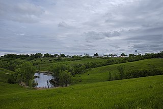
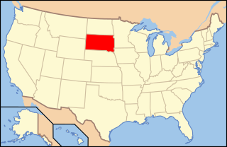
South Dakota is a landlocked state in the North Central region of the United States. It is also part of the Great Plains. South Dakota is named after the Dakota Sioux tribe, which comprises a large portion of the population — with nine reservations currently in the state — and has historically dominated the territory. South Dakota is the 17th-largest by area, but the 5th-least populous, and the 5th-least densely populated of the 50 United States. Pierre is the state capital, and Sioux Falls, with a population of about 213,900, is South Dakota's most populous city. The state is bisected by the Missouri River, dividing South Dakota into two geographically and socially distinct halves, known to residents as "East River" and "West River". South Dakota is bordered by North Dakota to the north, Minnesota to the east, Iowa to the southeast, Nebraska to the south, Wyoming to the west, and Montana to the northwest.

Todd County is a county in the U.S. state of South Dakota. As of the 2020 census, the population was 9,319. Todd County does not have its own county seat. Instead, Winner in neighboring Tripp County serves as its administrative center. Its largest city is Mission. The county was created in 1909, although it remains unorganized. The county was named for John Blair Smith Todd, a delegate from Dakota Territory to the United States House of Representatives and a Civil War general.

Potter County is a county in the U.S. state of South Dakota. As of the 2020 census, the population was 2,472. Its county seat is Gettysburg. The county was created in 1873 and organized in 1883.
Mellette County is a county in the U.S. state of South Dakota. As of the 2020 census, the population was 1,918. Its county seat is White River. The county was created in 1909, and was organized in 1911. It was named for Arthur C. Mellette, the last Governor of the Dakota Territory and the first Governor of the state of South Dakota.

Sioux County is a county located along the southern border of the U.S. state of North Dakota. As of the 2020 census, the population was 3,898. Its eastern border is the Missouri River and its county seat is Fort Yates.

The Mount Rushmore National Memorial is a national memorial centered on a colossal sculpture carved into the granite face of Mount Rushmore in the Black Hills near Keystone, South Dakota, United States. The sculptor, Gutzon Borglum, named it the Shrine of Democracy, and oversaw the execution from 1927 to 1941 with the help of his son, Lincoln Borglum. The sculpture features the 60-foot-tall (18 m) heads of four United States presidents: George Washington, Thomas Jefferson, Theodore Roosevelt, and Abraham Lincoln, chosen to represent the nation's birth, growth, development, and preservation. Mount Rushmore attracts more than two million visitors annually to the memorial park which covers 1,278 acres. The mountain's elevation is 5,725 feet (1,745 m) above sea level.

Mount Mitchell is the highest peak of the Appalachian Mountains and the highest peak in mainland North America east of the Mississippi River. It is located near Burnsville in Yancey County, North Carolina in the Black Mountain subrange of the Appalachians about 19 miles (31 km) northeast of Asheville. It is protected by Mount Mitchell State Park and surrounded by the Pisgah National Forest. Mount Mitchell's elevation is 6,684 feet (2,037 m) above sea level. Mount Mitchell is ranked 31st by topographic isolation.

White Butte is the highest natural point in the U.S. state of North Dakota. At an elevation of 3,506 ft, it is a prominent butte in Slope County, in the Badlands of the southwestern part of the state. It is located 3 miles east of U.S. 85 and about 6.5 mi (10 km) south of Amidon.

The Belle Fourche River is a tributary of the Cheyenne River, approximately 290 miles (470 km) long, in the U.S. states of Wyoming and South Dakota. It is part of the Mississippi River watershed via the Cheyenne and Missouri rivers. In the latter part of the 19th century, the Belle Fourche River was known as the North Fork of the Cheyenne River. Belle Fourche is a name derived from French meaning "beautiful fork".

Black Elk Peak, formerly known as Harney Peak, is the highest natural point in the U.S. state of South Dakota and the Midwestern United States. It lies in the Black Elk Wilderness area, in southern Pennington County, in the Black Hills. The peak lies 3.7 mi (6.0 km) west-southwest of Mount Rushmore. At 7,244 feet (2,208 m), it is the highest summit in the United States east of the Rocky Mountains. Though part of the North American Cordillera, it is generally considered to be geologically separate from the Rocky Mountains.

The Lakes of the Clouds are a set of tarns located at the 5,032 ft (1,534 m) col between Mount Monroe and Mount Washington in the White Mountains of the U.S. state of New Hampshire. The lakes form the source of the Ammonoosuc River, a tributary of the Connecticut River. They are recorded by the Geographic Names Information System as the highest elevation lakes in the United States east of South Dakota.

Black Hills National Forest is located in southwestern South Dakota and northeastern Wyoming, United States. The forest has an area of over 1.25 million acres (5,066 km2) and is managed by the Forest Service. Forest headquarters are located in Custer, South Dakota. There are local ranger district offices in Custer, Rapid City, and Spearfish in South Dakota, and in Sundance, Wyoming.

The Geography of North Dakota consists of three major geographic regions: in the east is the Red River Valley, west of this, the Missouri Plateau. The southwestern part of North Dakota is covered by the Great Plains, accentuated by the Badlands. There is also much in the way of geology and hydrology.
Terry Peak is a mountain and ski area in the west central United States, in the Black Hills of South Dakota outside of Lead. With an elevation of 7,064 feet (2,153 m) above sea level, it is the most prominent peak in the Northern Black Hills area, and the sixth highest summit in the range; the tallest is Black Elk Peak at 7,244 feet (2,208 m).

South Dakota is a state located in the north-central United States. It is usually considered to be in the Midwestern region of the country. The state can generally be divided into three geographic regions: eastern South Dakota, western South Dakota, and the Black Hills. Eastern South Dakota is lower in elevation and higher in precipitation than the western part of the state, and the Black Hills are a low, isolated mountain group in the southwestern corner of the state. Smaller sub-regions in the state include the Coteau des Prairies, Missouri Coteau, James River Valley, and the Dissected Till Plains. Geologic formations in South Dakota range in age from two billion-year-old Precambrian granite in the Black Hills to glacial till deposited over the last few million years. South Dakota is the 17th-largest state in the country.
The following is an alphabetical list of articles related to the U.S. state of South Dakota.
Lists of mountains can be organized by continent and more specifically by country and province/state:
Odakota Mountain is a mountain in western Pennington County, South Dakota, about 9 miles (14 km) west of Hill City. It is the 2nd highest point in the Black Hills and in South Dakota.