
The Northumberland Strait is a strait in the southern part of the Gulf of Saint Lawrence in eastern Canada. The strait is formed by Prince Edward Island and the gulf's eastern, southern, and western shores.
The Confederation Bridge is a box girder bridge carrying the Trans-Canada Highway across the Abegweit Passage of the Northumberland Strait, linking the province of Prince Edward Island with the mainland province of New Brunswick. Opened May 31, 1997, the 12.9-kilometre (8.0 mi) bridge is Canada's longest bridge and the world's longest bridge over ice-covered water.
Central Bedeque is a former municipality that previously held community status in the Canadian province of Prince Edward Island. It was dissolved through its amalgamation with the Community of Bedeque on November 17, 2014, to create the Community of Bedeque and Area. It is located north of Borden-Carleton within Lot 26, Prince County. Its primary industry is agriculture.

The Prince Edward Island Railway (PEIR) was a historic Canadian railway in Prince Edward Island (PEI). The railway ran tip-to-tip on the island, from Tignish in the west to Elmira in the east, with major spurs serving Borden-Carleton's train ferry dock, the capital in Charlottetown, Montague and Georgetown and the original eastern terminus at Souris. A major spur from Charlottetown served Murray Harbour on the south coast.

Borden-Kinkora is a provincial electoral district for the Legislative Assembly of Prince Edward Island, Canada.

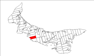
Borden-Carleton is a town in Prince County in the Canadian province of Prince Edward Island. It is situated on the south shore fronting on the Northumberland Strait. The town was originally incorporated as a community on April 12, 1995, through the amalgamation of the town of Borden and the community of Carleton. The town of Borden opted to demote its status to a community in light of a declining tax base with the pending completion of the Confederation Bridge and the closure of the Marine Atlantic ferry service. Borden-Carleton became a town on July 31, 2012.

Lot 29 is a township in Queens County, Prince Edward Island, Canada. It is part of Hillsboro Parish. Lot 29 was awarded to Admiral Charles Saunders in the 1767 land lottery.

Lot 15 is a township in Prince County, Prince Edward Island, Canada. It is part of Richmond Parish. Lot 15 was awarded to Guy Carleton, 1st Baron Dorchester in the 1767 land lottery.
Lot 27 is a township in Prince County, Prince Edward Island, Canada. It is part of St. David's Parish. Lot 27 was awarded to merchants James Searle and John Russell Spence in the 1767 land lottery.
Route 1 is a 120-kilometre (75 mi) long provincial highway that serves as the Prince Edward Island section of the Trans-Canada Highway. Route 1 traverses the southern shores of Prince Edward Island, from the Confederation Bridge in Borden-Carleton to the Wood Islands ferry dock, and bypasses the provincial capital, Charlottetown. It is an uncontrolled access 2-lane highway with a maximum speed limit of 90 km/h (55 mph), except within towns and urban areas.

Prince County is located in western Prince Edward Island, Canada. The county's defining geographic feature is Malpeque Bay, a sub-basin of the Gulf of St. Lawrence, which creates the narrowest portion of Prince Edward Island's landmass, an isthmus upon which the city of Summerside is located.
Grand Prix Wrestling (GPW) was a professional wrestling promotion run and owned by Emile Duprée. It toured parts of New Brunswick, Prince Edward Island and Nova Scotia. It has no connection with Paul Vachon's Grand Prix Wrestling promotion of Montreal in the 1970s.
Route 1A is a 20-kilometre (12 mi) long provincial highway in central Prince Edward Island. The route is a spur route of the Route 1 which connects the Trans-Canada Highway near Borden-Carleton and the Confederation Bridge with the city of Summerside. It is an uncontrolled access 2-lane highway with a maximum speed limit of 90 km/h (55 mph) and is considered a "Core route" of Canada's National Highway System. Route 1A is unnamed except for the portion within Summerside city limits, where it is known as Read Drive.
Victoria is a rural municipality in Prince Edward Island, Canada. A historic seaport, the community is situated at the extreme southwestern edge of Queens County in the township of Lot 29.
Crapaud is a rural municipality in Prince Edward Island, Canada. It is located north of Victoria in the township of Lot 29.
George Brecken Nicholson was a Canadian businessman and politician. Nicholson served as a Conservative and Unionist member of the House of Commons of Canada. He was born in Crapaud, Prince Edward Island and became a lumber merchant.
Tryon is an unincorporated area in Prince County, Prince Edward Island, Canada. Situated on Route 1 and Route 10, it lies within the township of Lot 28 which in 2006 had a population of 880 people. Tryon is not far from Crapaud, Prince Edward Island.
Route 10 is a 23.2 km (14.4 mi), two-lane, uncontrolled-access, secondary provincial highway in western Prince Edward Island, Canada. Its western terminus is at Route 1A in Bedeque and Area and its eastern terminus is at Route 1 in Tryon.
