Prince Edward Island is one of the thirteen provinces and territories of Canada. It is the smallest province in terms of land area and population, but the most densely populated. The island has several nicknames: "Garden of the Gulf", "Birthplace of Confederation" and "Cradle of Confederation". Its capital and largest city is Charlottetown. It is one of the three Maritime provinces and one of the four Atlantic provinces.

Cape Tormentine is a local service district in southeastern New Brunswick, Canada. It is located on the Northumberland Strait at the Abegweit Passage, the shortest crossing between Prince Edward Island and the mainland. It once flourished as a transportation hub between New Brunswick and Prince Edward Island but has been in decline since 1997 when the ferry service was closed due to the opening of the Confederation Bridge. At the Canada 2011 Census the population was 108, three quarters what it was at the 2006 census.
Route 16 is a 2-lane highway in the Canadian province of New Brunswick. The 52 km (32 mi) route begins at a T intersection with Aulac Road at Aulac and ends at the western abutment of the Confederation Bridge at Cape Jourimain.

Borden-Carleton is a town in Prince County in the Canadian province of Prince Edward Island. It is situated on the south shore fronting on the Northumberland Strait. The town was originally incorporated as a community on April 12, 1995, through the amalgamation of the town of Borden and the community of Carleton. The town of Borden opted to demote its status to a community in light of a declining tax base with the pending completion of the Confederation Bridge and the closure of the Marine Atlantic ferry service. Borden-Carleton became a town on July 31, 2012.

Lot 2 is a township in Prince County, Prince Edward Island, Canada created during the 1764–1766 survey of Samuel Holland. It is part of North Parish.

Lot 3 is a township in Prince County, Prince Edward Island, Canada created during the 1764–1766 survey of Samuel Holland. It is part of North Parish.

Lot 8 is a township in Prince County, Prince Edward Island, Canada. It is part of Halifax Parish. Lot 8 was awarded to Arnold Nisbett (M.P.) in the 1767 land lottery, passed to William Kilpatrick and Benjamin Todd in 1775, and to Todd's heirs in 1783.
Lot 16 is a township in Prince County, Prince Edward Island, Canada. It is part of Richmond Parish.

Lot 28 is a township in Prince County, Prince Edward Island, Canada. It is part of St. David's Parish. Lot 28 was awarded to Samuel Holland in the 1767 land lottery.
Alberton is a Canadian town located in Prince County, Prince Edward Island. It is situated in the western part of the county in the township of Lot 5.

Prince County is located in western Prince Edward Island, Canada. The county's defining geographic feature is Malpeque Bay, a sub-basin of the Gulf of St. Lawrence, which creates the narrowest portion of Prince Edward Island's landmass, an isthmus upon which the city of Summerside is located.
Belmont is a Canadian rural farming community located in the larger community of Lot 16 in central Prince County, Prince Edward Island. Lot 16 is actually three communities: Belmont, Central, and Southwest Lot 16, and is one of the last communities on Prince Edward Island to continue using their lot designation from the original Island survey by Samuel Holland in the 18th century.
Ellerslie-Bideford was a municipality that held community status in Prince Edward Island, Canada. It was located in Prince County on Lot 12.
Belfast is a rural municipality in Prince Edward Island, Canada. It is located in southeastern Queens County in the townships of Lot 57 and Lot 58.

Wood Islands is a rural farming and fishing community located in southeastern Queens County, Prince Edward Island on the Northumberland Strait. It takes its name from several small forested islands, then located several hundred metres offshore in the Northumberland Strait. The community of Wood Islands falls within the larger PEI Township of Lot 62, which had a population in 2011 of 470 residents, a 13% decrease from the 2006 census count of 540. While the named islands are located on maps by Jacques-Nicolas Bellin: Karte Bellin, 1744: 'I a Bova' and Louis Franquet: Cartes Franquet, 1751: 'Isle a Bois', it was Samuel Johannes Holland who correctly surveyed and depicted the islands, about their basin. The 'European' settlement of Wood Islands began in 1803, but saw its most noted arrivals in 1807 with the arrival, after wintering in Pinette, of a large party of Scottish settlers from the Spencer.

Charlottetown is the capital and largest city of the Canadian province of Prince Edward Island, and the county seat of Queens County. Named after Queen Charlotte, Charlottetown was an unincorporated town until it was incorporated as a city in 1855.
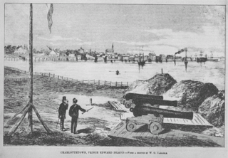
The History of Charlottetown can be traced back to the original French military settlement established on the site in 1720. Over the years Charlottetown has grown to become the largest and most important city on Prince Edward Island.

The Cape Tryon Light is a lighthouse on the western north coast of Prince Edward Island, Canada, located on Cousins Shore about 4 km (2.5 mi) west of the cape. The station was built in 1905 and it characterised as a white building with red trim; with the lantern painted red.
The Municipality of Malpeque Bay is a municipality that holds community status in Prince Edward Island, Canada. It is located in Prince County and Queens County.
Route 12 is a 112 km (70 mi), two-lane, uncontrolled-access, secondary highway in western Prince Edward Island, Canada. Its southern terminus is at Route 11 in Miscouche and its northern terminus is at the North Cape Hiking Trail in Tignish. The route parallels Route 2 as it travels toward the North Cape.
