Mount Galatea is the highest peak of the Kananaskis Range, a subrange of the Canadian Rockies in the province of Alberta. It is located in the upper Spray Lakes Valley of the Kananaskis Country system of provincial parks. The mountain was named after the Royal Navy cruiser HMS Galatea.

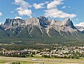
Canmore is a town in Alberta, Canada, located approximately 81 kilometres (50 mi) west of Calgary near the southeast boundary of Banff National Park. It is located in the Bow Valley within Alberta's Rocky Mountains. The town shares a border with Kananaskis Country to the west and south and the Municipal District of Bighorn No. 8 to the north and east. With a population of 17,036 in 2023, Canmore is the fifth-largest town in Alberta.

Mount Hungabee, officially Hungabee Mountain, is a mountain located on the boundaries of Banff National Park and Yoho National Park on the Continental Divide at the head of Paradise Valley, in Canada. The peak was named in 1894 by Samuel Allen after the Stoney Indian word for "chieftain" as the mountain is higher than its neighbouring peaks. The mountain can be seen from the Icefields Parkway (#93) in the upper Bow Valley.

Anûkathâ Îpa is an outlier of Mount Charles Stewart in the Canadian Rockies of Alberta. It is one of the most prominent landmarks in the vicinity of Canmore, Alberta.

Mount Rundle is a mountain in Canada's Banff National Park overlooking the towns of Banff and Canmore, Alberta. The Cree name was Waskahigan Watchi or house mountain. In 1858 John Palliser renamed the mountain after Reverend Robert Rundle, a Methodist invited by the Hudson's Bay Company to do missionary work in western Canada in the 1840s. He introduced syllabics there—a written language developed for the Cree, as part of his missionary work. He only visited the Stoney-Nakoda of the area around what is now called Mount Rundle in 1844 and 1847.

The Three Sisters are a trio of peaks near Canmore, Alberta, Canada. They are known individually as Big Sister, Middle Sister and Little Sister.

Wiwaxy Peaks is a 2,706-metre (8,878-foot) mountain near Lake O'Hara in Yoho National Park, in the Canadian Rockies of British Columbia, Canada. The Burgess Shale animal Wiwaxia corrugata is named after it. The nearest higher neighbor is Mount Huber, 1.7 km (1.1 mi) to the east.

Mount Lyell is a mountain on the Alberta–British Columbia border in western Canada. Comprising five distinct summits, Mount Lyell reaches a height of 3,498 m (11,476 ft). The mountain was named by James Hector in 1858 in recognition of Scottish geologist Sir Charles Lyell.

East End of Rundle (EEOR) is a mountain located immediately west of the town of Canmore, Alberta and immediately west of the Spray Lakes road in the Canadian Rockies. Mount Rundle occupies the space between Canmore and Banff on the southwest side of the Trans-Canada Highway.

Ha Ling Peak is a peak at the northwestern end of Ehagay Nakoda — a mountain located immediately south of the town of Canmore just east of the Spray Lakes road in Alberta's Canadian Rockies. It was previously named Chinaman's Peak but the name was changed to be less offensive. It was the subject of a 2018 CBC Documentary titled 'Ha Ling Peak' that follows the controversy and renaming of the mountain.
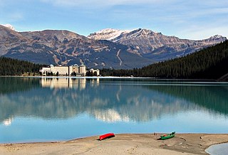
Lake Louise is a glacial lake within Banff National Park in Alberta, Canada. Situated 11 km (6.8 mi) east of the border with British Columbia, Lake Louise is located 5 km (3.1 mi) west of the hamlet of Lake Louise and the Trans-Canada Highway.

Mount Allen is a mountain in the Canadian Rockies, on the Continental Divide, which forms the provincial boundary between British Columbia and Alberta in this region. J. Monroe Thorington named this mountain for Samuel Evans Stokes Allen in 1924. Allen was an American cartographer who mapped this area of the Rockies in 1894–1895. Allen had named this mountain "Shappee", the Stoney language word for "six", as part of his naming of the ten mountains in the Valley of the Ten Peaks. The peak forms part of the backdrop to Moraine Lake in Banff National Park.
Mount Tuzo is a mountain located within the Valley of the Ten Peaks in the Canadian Rockies, along the Continental Divide, which forms the provincial boundary between British Columbia and Alberta in Western Canada. It also lies on the boundary shared by Banff National Park and Kootenay National Park.

Mount Bowlen is located on the border of Alberta and British Columbia and forms part of the Valley of the Ten Peaks. It was named in 1953 after John J. Bowlen, a native of Prince Edward Island, successful Alberta rancher, honorary chief of the Blackfoot, and a Lieutenant Governor of Alberta. Its former name was "Yamnee", which translates to the number 3 in the local Nakoda (Stoney) language.

Mount Murchison is a 3,348-metre (10,984 ft) mountain summit located at the convergence of the North Saskatchewan River valley and Mistaya River valley of Banff National Park, in the Canadian Rockies of Alberta, Canada. The main summit has two high points: the Southeast Peak is 3,348 m, whereas the Northwest Peak is 3,333 m and separated by 700 m distance. Its nearest higher peak is Mount Cline, 15.71 km (9.76 mi) to the north. Mount Murchison is situated immediately southeast of the confluence of the North Saskatchewan River, Mistaya River, and Howse River near Saskatchewan Crossing, where the Icefields Parkway intersects with the David Thompson Highway.

Mount Lougheed is a 3,107-metre (10,194-foot) triple-peak mountain located between Spray Lakes Reservoir and the Wind Valley of Kananaskis Country in the Canadian Rockies of Alberta, Canada. The highest summit is known as Peak 2. Peak 1 to the northwest is 3,080 metres. Peak 3 to the southeast is 3,010 metres. The nearest higher peak is Wind Mountain, 2.0 km (1.2 mi) to the southeast. Mount Lougheed is a conspicuous landmark that can be seen from Highway 1, the Trans-Canada Highway at Dead Man's Flats which is east of Canmore.

Wind Mountain is a 3,153-metre (10,344-foot) mountain summit located in Kananaskis Country in the Canadian Rockies of Alberta, Canada. Wind Mountain's nearest higher peak is Mount Galatea, 13.0 km (8.1 mi) to the south, and both are part of the Kananaskis Range. Wind Mountain can be seen from the Trans-Canada Highway in the Bow River valley, and from Highway 40.

Ehagay Nakoda is a multipeaked massif located immediately south of the town of Canmore just east of the Spray Lakes road in Alberta's Canadian Rockies. The mountain sports two subsidiary peaks with commemorative names, Mount Lawrence Grassi and Ha Ling Peak on the northwestern end. It also sports two other named peaks: Ship's Prow on the southeastern side, and Miners Peak. The mountain is separated from Mount Rundle by Whiteman's Gap, and is separated to the South from The Three Sisters by Three Sisters Pass.

Andrea Lorenzo Grassi was an Italian miner known as Lawrence Grassi. He moved to Canada in 1912, taking on work with the Canadian Pacific Railway (CPR), before settling down in Canmore, Alberta, in 1916. There he worked as a miner, until he retired. Grassi became well known for his passion for the mountains, building hiking trails around Canmore and Lake O'Hara, Yoho National Park. Several plaques have been emplaced at these trails to recognize Grassi for this work.
Association Peak is a 2,362-metre (7,749 ft) mountain summit located in Alberta, Canada.