Mount Pisgah (mountain in North Carolina)

Last updated
Mount Pisgah
Mount Pisgah (North Carolina) Oct 2016.jpg
View of Mount Pisgah from the Blue Ridge Parkway, October 2016
Highest point
Elevation 5,721 ft (1,744 m)
Coordinates 35°25′32″N82°45′25″W / 35.4255°N 82.7569°W / 35.4255; -82.7569 Coordinates: 35°25′32″N82°45′25″W / 35.4255°N 82.7569°W / 35.4255; -82.7569
Geography
Location Buncombe / Haywood counties, North Carolina, U.S.
Parent range Appalachian Mountains
Topo map USGS Cruso
Climbing
Easiest route Hike

Mount Pisgah is a mountain in the Appalachian Mountain Range and part of the Blue Ridge Mountains of North Carolina, United States. The mountain's height is 5,721 feet (1,744 m) above sea level, and it sits approximately 15 miles (24 kilometers) southwest of Asheville, near the crossing of the boundaries of Buncombe, Haywood, Henderson and Transylvania counties. It is located on the border of Buncombe and Haywood counties, close to the point where Henderson and Transylvania meet them, but not actually within the latter two counties. The mountain is easily accessible via a hiking trail from the Blue Ridge Parkway, near the Pisgah Inn.

Contents

Broadcasting controversy

The prominent tower in the picture at the crest of Mount Pisgah, on what is known as Pisgah Ledge, is a 339-foot-tall (103 m) television broadcast tower owned by Chesapeake Television, Incorporated, doing business as the Sinclair Broadcast Group, licensee of WLOS TV 13.x, transmitting on VHF channel 13, from nearby Asheville, North Carolina. It is the highest television antenna east of the Mississippi River, at 2,814 feet (858 m) above the surrounding valley floor, and 6,023 feet (1,836 m) above mean sea level, according to the Federal Communications Commission. Co-located on the tower is WUNF-TV 33.x on UHF channel 25, WKSF FM 99.9, WXL56 on 162.400 MHz from the Greenville/Spartanburg office of the National Weather Service, and ham radio vhf (146.760 N2GE). From this location, the stations cover the western Carolinas media market. Due to the terrain shielding of the surrounding mountains, and the much lower and flatter Piedmont (and therefore much greater height above average terrain) toward the southeast, the stations actually cover much more of South Carolina than they do North Carolina.

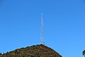
On May 22, 2001, the United States Forest Service decided to allow WLOS TV to build a replacement television transmission tower on top of Mount Pisgah. The new tower would have been a lighter-weight tower to support the station's digital TV antenna that would have replaced the heavier channel 13 analog antenna, fulfilling the government-ordered transfer to digital transmission. The old tower would not have supported both the heavy analog antenna, plus the added weight of a full power digital antenna. The Blue Ridge Parkway and several conservation organizations had opposed building a new tower on the peak located adjacent to the Parkway and repeatedly requested the Forest Service explore alternative locations. In 2009, the controversy was resolved, with the FCC and the U.S. Department of the Interior allowing WLOS to maintain its old tower on the summit after the analog antenna was removed, and the station to make needed adjustments to its digital antennas now mounted on the tower.

Recreation

The trail leading to the summit of Mt. Pisgah starts at milepost 407 of the Blue Ridge Parkway on the west side of the road at an overlook labeled "Mt. Pisgah Parking". The trail is 1.6 miles long and is of moderate difficulty (sections near the summit can be rather steep). There is a small observation deck near the TV tower at the summit.

Leading up the mountain from the valley floor, is a still-operating cable car that is used to ferry broadcasting equipment to the building. The cable car also ferries engineers during bad weather, for mandatory transmitter work.

Also at the Mt. Pisgah Parking area is the Buck Spring trailhead. A short walk down the Buck Spring Trail brings visitors to a historic exhibit located at the foundation stone remains of the George Vanderbilt hunting lodge.

On the east side of the Parkway at milepost 407 is the Mt. Pisgah Picnic Area. The picnic area includes grills, tables and restroom facilities. All are ADA/handicapped accessible.

The Pisgah Inn Lodge Restaurant and Country Store, as well as the Mt. Pisgah Campground is located at milepost 408 of the Blue Ridge Parkway. Several other trails can be accessed from the campground or the Inn.

See also

Related Research Articles

Transylvania County, North Carolina U.S. county in North Carolina

Transylvania County is a county in the U.S. state of North Carolina. Its 2018 U.S. Census population estimate is 34,215. Its county seat is Brevard.

Haywood County, North Carolina U.S. county in North Carolina

Haywood County is a county located in the U.S. state of North Carolina. As of the 2010 census, the population was 59,036. The county seat and its largest city is Waynesville. Haywood County is part of the Asheville, NC Metropolitan Statistical Area.

Buncombe County, North Carolina U.S. county in North Carolina

Buncombe County is a county located in the U.S. state of North Carolina. It is classified within Western North Carolina. The 2010 census reported the population was 238,318. Its county seat is Asheville.

Blue Ridge Parkway Scenic parkway in the United States

The Blue Ridge Parkway is a National Parkway and All-American Road in the United States, noted for its scenic beauty. The parkway, which is America's longest linear park, runs for 469 miles (755 km) through 29 Virginia and North Carolina counties, linking Shenandoah National Park to Great Smoky Mountains National Park. It runs mostly along the spine of the Blue Ridge, a major mountain chain that is part of the Appalachian Mountains. Its southern terminus is at U.S. Route 441 (US 441) on the boundary between Great Smoky Mountains National Park and the Cherokee Indian Reservation in North Carolina, from which it travels north to Shenandoah National Park in Virginia. The roadway continues through Shenandoah as Skyline Drive, a similar scenic road which is managed by a different National Park Service unit. Both Skyline Drive and the Virginia portion of the Blue Ridge Parkway are part of Virginia State Route 48 (SR 48), though this designation is not signed.

French Broad River River in North Carolina and Tennessee, United States

The French Broad River flows 218 miles (351 km) from near the town of Rosman in Transylvania County, North Carolina, into the state of Tennessee. Its confluence with the Holston River at Knoxville is the beginning of the Tennessee River. The river flows through the counties of Transylvania, Buncombe, Henderson, and Madison in North Carolina, and Cocke, Jefferson, Sevier, and Knox in Tennessee. It drains large portions of the Pisgah National Forest and the Cherokee National Forest.

WMYA-TV MyNetworkTV affiliate in Anderson, South Carolina

WMYA-TV, virtual channel 40, is a MyNetworkTV-affiliated television station licensed to Anderson, South Carolina, United States, serving Upstate South Carolina and Western North Carolina. The station is owned by Cunningham Broadcasting; the Sinclair Broadcast Group, which owns Asheville, North Carolina-licensed ABC affiliate WLOS, operates WMYA-TV under a local marketing agreement (LMA). However, Sinclair effectively owns WMYA-TV as the majority of Cunningham's stock is owned by the family of deceased group founder Julian Smith. The two stations share studios on Technology Drive in Asheville; WMYA-TV's transmitter is located in Fountain Inn, South Carolina.

Mount Mitchell State Park

Mount Mitchell State Park is a 4,789-acre (19.38 km2) North Carolina state park in Yancey County, North Carolina in the United States. Established in 1915 by the state legislature, it became the first state park of North Carolina. By doing so, it also established the North Carolina State Parks System within the same bill.

WLOS ABC affiliate in Asheville, North Carolina

WLOS, virtual and VHF digital channel 13, is an ABC-affiliated television station licensed to Asheville, North Carolina, United States, serving Western North Carolina and Upstate South Carolina. The station is owned by the Sinclair Broadcast Group, which also operates Anderson, South Carolina-licensed MyNetworkTV affiliate WMYA-TV under a local marketing agreement (LMA) with owner Cunningham Broadcasting. However, Sinclair effectively owns WMYA as the majority of Cunningham's stock is owned by the family of deceased group founder Julian Smith. The two stations share studios on Technology Drive in Asheville; WLOS' transmitter is located on Mount Pisgah in Haywood County, North Carolina. On cable, the station is available on Charter Spectrum channel 13.

Pisgah National Forest

Pisgah National Forest is a National Forest in the Appalachian Mountains of western North Carolina. It is administered by the United States Forest Service, part of the United States Department of Agriculture. The Pisgah National Forest is completely contained within the state of North Carolina. The forest is managed together with the other three North Carolina National Forests from common headquarters in Asheville, North Carolina. There are local ranger district offices located in Pisgah Forest, Mars Hill, and Nebo.

Mountains-to-Sea Trail Long-distance hiking trail in North Carolina, United States

The Mountains-to-Sea State Trail (MST) is a long-distance trail for hiking and backpacking, that traverses North Carolina from the Great Smoky Mountains to the Outer Banks. The trail's western endpoint is at Clingman's Dome, where it connects to the Appalachian Trail in the Great Smoky Mountains National Park. Its eastern endpoint is in Jockey's Ridge State Park on the tallest sand dune on the east coast. The trail is envisioned as a scenic backbone of an interconnected trail system spanning the state. As such, the trail's route attempts to connect as many trail systems and natural scenic areas as practicable. A little over half of the trail is complete in multiple segments across the state.

WKSF is a country music station licensed to serve Old Fort, North Carolina. The iHeartMedia, Inc. station broadcasts from a tower on Mount Pisgah, southwest of Asheville at 99.9 FM with an ERP of 53,000 watts. The tower is shared with former sister station WLOS (ABC) and WUNF-TV (PBS).

WKPT-TV Cozi TV affiliate in Kingsport, Tennessee

WKPT-TV, virtual channel 19, is a Cozi TV-affiliated television station licensed to Kingsport, Tennessee, United States, serving the Tri-Cities area of northeastern Tennessee and southwestern Virginia. Owned by the Glenwood Communications Corporation, it is sister to low-powered Class A MeTV affiliate WAPK-CD and several radio stations, including WKPT. All of the outlets share studios on Commerce Street in downtown Kingsport; WKPT-TV's transmitter is located on Holston Mountain in the Cherokee National Forest. On cable, WKPT-TV can be seen on Comcast Xfinity channel 9 and Charter Spectrum channel 6.

Devils Courthouse

Devil's Courthouse is a mountain in the Appalachian Mountains of western North Carolina in the United States of America. The mountain is located at the Western edge of the Pisgah National Forest about 10 miles northwest of Brevard and 28 miles southwest of Asheville. Located at milepost 422.4 of the Blue Ridge Parkway, the Devil's Courthouse has a moderate/strenuous trail climbing a half mile to its peak where panoramic views can be seen.

Waterrock Knob

Waterrock Knob is a mountain peak in the U.S. state of North Carolina. It is the highest peak in the Plott Balsams and is the 16th-highest mountain in the Eastern United States.

Great Craggy Mountains

The Great Craggy Mountains, commonly called the Craggies, are a mountain range in western North Carolina, United States. They are a subrange of the Blue Ridge Mountains and encompass an area of approx. 194 sq mi (503 km²). They are situated in Buncombe County, North Carolina, 14 miles northeast of Asheville. The Black Mountains lie to the northeast, across the upper Cane River valley.

Woodys Knob

Woody's Knob, at an elevation of 4,170 feet, is a summit or "knob" in the Blue Ridge Mountains and one of the highest points in the unincorporated village of Little Switzerland and in Mitchell County, North Carolina.

Black Balsam Knob

Black Balsam Knob, also known as Black Balsam Bald, is in the Pisgah National Forest southwest of Asheville, North Carolina, near milepost 420 on the Blue Ridge Parkway. It is the second highest mountain in the Great Balsam Mountains. The Great Balsams are within the Blue Ridge Mountains, which are part of the Appalachian Mountains. It is the 23rd highest of the 40 mountains in North Carolina over 6000 feet.

Candler is an unincorporated community in Buncombe County, North Carolina, United States. It lies on North Carolina Highway 151 and U.S. Routes 19, 23, and 74 Business, at an elevation of 2,122.7 feet (647 m). The ZIP code of Candler is 28715. The community is part of the Asheville Metropolitan Statistical Area.

Richland Balsam

Richland Balsam is a mountain in the Great Balsam Mountains in the U.S. state of North Carolina. Rising to an elevation of 6,410 feet (1,950 m), it is the highest mountain in the Great Balsam range, is among the 20 highest summits in the Appalachian range, and is the ninth highest peak in the East of the United States. The Blue Ridge Parkway reaches an elevation of 6,053 feet (1,845 m)— the parkway's highest point— as it passes over Richland Balsam's southwestern slope. The Jackson County-Haywood County line crosses the mountain's summit.

The Blue Ridge National Heritage Area is a federally designated National Heritage Area encompassing the twenty-five westernmost counties of North Carolina, which are associated with the Blue Ridge Mountains. The designation provides a framework for the promotion and interpretation of the area's cultural and historic character, and the preservation of the natural and built environment. The National Heritage Area includes the North Carolina portions of Great Smoky Mountains National Park and the Blue Ridge Parkway. Other attractions include Mount Mitchell in Pisgah National Forest, Nantahala National Forest and the North Carolina portion of the Appalachian Trail. The Qualla Boundary of the Eastern Band of Cherokee Indians is also within the National Heritage Area. The area's musical heritage and folk craftsmanship are also recognized by the National Heritage Area.

References