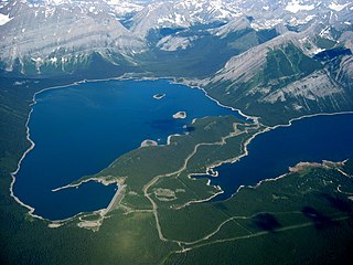
Upper Kananaskis Lake is a natural lake that was turned into a reservoir in Kananaskis Country in Alberta, Canada.

Mount Engadine is a 2,972-metre (9,751-foot) mountain summit located in the Spray River Valley of Kananaskis Country, in the Canadian Rockies of Alberta, Canada. It was named in 1917 after HMS Engadine, a seaplane tender of the Royal Navy present at the Battle of Jutland during World War I. The mountain is located in the Kananaskis Range in Alberta.

Mount James Walker is a 3,035-metre (9,957-foot) mountain summit located in Kananaskis Country in the Canadian Rockies of Alberta, Canada. Mount James Walker is situated within Spray Valley Provincial Park, and its nearest higher peak is Mount Galatea, 5.0 km (3.1 mi) to the northwest.

Storm Mountain is a 3,158-metre (10,361-foot) mountain summit located on the Continental Divide on the shared border of Alberta and British Columbia in Canada. It is situated on the shared boundary of Kootenay National Park with Banff National Park in the Canadian Rockies. It is a large peak near the north end of the Ball Range, in the Bow River Valley opposite Castle Mountain. Vermilion Pass is situated to the northwest of the mountain, and Stanley Peak to the southwest. The nearest higher peak is Mount Ball, 5.7 km (3.5 mi) to the south.

Mount Glasgow is a prominent 2,935-metre (9,629 ft) pyramid-shaped summit located between the Elbow River valley and Little Elbow River valley of Kananaskis Country in the Canadian Rockies of Alberta, Canada. The peak is visible from Calgary, weather permitting. Mount Glasgow's nearest higher peak is Mount Cornwall, 2.0 km (1.2 mi) to the southwest.

Mount Black Prince is a 2,939-metre (9,642-foot) mountain summit located in Peter Lougheed Provincial Park in the Canadian Rockies of Alberta, Canada. Its nearest higher peak is Mount Smith Dorrien, 5.8 km (3.6 mi) to the northwest. The mountain can be seen from Highway 742, also known as Smith-Dorrien/Spray Trail.

Mount Invincible is a 2,700-metre (8,900-foot) mountain summit located in Peter Lougheed Provincial Park in the Canadian Rockies of Alberta, Canada. The peak is visible from Alberta Highway 40, and the Upper and Lower Kananaskis Lakes area. Mount Invincible's nearest higher peak is Mount Warspite, 2.6 km (1.6 mi) to the northwest.

Mount McGillivray is a 2,451-metre (8,041-foot) mountain summit located in the Bow Valley of Kananaskis Country in the Canadian Rockies of Alberta, Canada. Its nearest higher peak is Skogan Peak, 3.0 km (1.9 mi) to the southeast. Mount McGillivray is a landmark that can be seen from Highway 1, the Trans-Canada Highway in the Exshaw area.

Mount Sparrowhawk is a 3,121-metre (10,240 ft) mountain summit located in Kananaskis Country in the Canadian Rockies of Alberta, Canada. Mount Sparrowhawk's nearest higher peak is Mount Bogart, 3.6 km (2.2 mi) to the southeast. Sparrowhawk's south slope was a candidate to be used as a ski hill for the alpine events at the 1988 Winter Olympics, but nearby Mount Allan's Nakiska was selected instead.

Mount Evan-Thomas is a 3,097-metre (10,161-foot) mountain summit located in the Opal Range of the Canadian Rockies of Alberta, Canada. Mount Evan-Thomas is the highest point in the Opal Range. It is situated in the Kananaskis River Valley northeast of Lower Kananaskis Lake and east of Highway 40 in Peter Lougheed Provincial Park. Its nearest higher peak is Mount Rae, 18.0 km (11.2 mi) to the south-southeast.

Mount Lyautey is a 3,045-metre (9,990-foot) mountain summit located in Kananaskis Country in the Canadian Rockies of Alberta, Canada. Mount Lyautey is situated 2.0 kilometres east of the Continental Divide, within Peter Lougheed Provincial Park. Its nearest higher peak is Mount Joffre, 8.0 km (5.0 mi) to the south. Mount Lyautey can be seen from Upper Kananaskis Lake and Alberta Highway 40.

Gap Mountain is a 2,675-metre (8,776-foot) mountain summit located at the southern end of the Opal Range in the Canadian Rockies of Alberta, Canada. The nearest higher neighbor is Elpoca Mountain, 2 km (1.2 mi) to the east. Gap Mountain is situated 5 km (3.1 mi) south of Mount Wintour, within Peter Lougheed Provincial Park. Gap Mountain is a conspicuous peak seen from Alberta Highway 40 at Highwood Pass. It is a popular climbing destination because it offers exposed scrambling on its eastern flanks with excellent summit views of Kananaskis Country.

Mount Indefatigable is a 2,667-metre (8,750-foot) mountain summit located in Peter Lougheed Provincial Park in the Canadian Rockies of Alberta, Canada. The peak is visible from Alberta Highway 40, and the Kananaskis Lakes area. Mount Indefatigable's nearest higher neighbour is Mount Invincible, 1.8 km (1.1 mi) to the northwest.

Mount Sarrail is a 3,159-metre (10,364-foot) mountain summit located in Kananaskis Country in the Canadian Rockies of Alberta, Canada. Mount Sarrail is situated 1.0 kilometre north of the Continental Divide, within Peter Lougheed Provincial Park. Its nearest higher peak is Mount Foch, 1.0 km (0.62 mi) to the southeast. Mount Sarrail can be seen from Upper Kananaskis Lake and Alberta Highway 40.

Mount Shark is a 2,786-metre (9,140-foot) mountain summit located in the Spray Valley of Kananaskis Country at the northern tip of the Spray Mountains range. It is situated on the southern boundary of Banff National Park in the Canadian Rockies of Alberta, Canada. Mount Shark in not visible from any road in Banff Park, however, it can be seen from Alberta Highway 742, also known as the Smith-Dorrien/Spray Trail. Mount Shark's nearest higher peak is Mount Smuts, 3.0 km (1.9 mi) to the southeast.

Mount Smuts is a 2,938-metre (9,639-foot) mountain summit located in the Canadian Rockies of Alberta, Canada. It is set in the Spray Valley near the northern end of the Spray Mountains range. It is situated on the common boundary shared by Peter Lougheed Provincial Park with Banff National Park. Mount Smuts is not visible from any road in Banff Park, however it can be seen from Alberta Highway 742, also known as Smith-Dorrien/Spray Trail in Kananaskis Country. Mount Smuts' nearest higher neighbor is Mount Birdwood, 2.8 km (1.7 mi) to the south-southeast.

Fisher Peak is a 3,053-metre (10,016-foot) mountain summit located in the Fisher Range of Kananaskis Country in the Canadian Rockies of Alberta, Canada. Fisher Peak is the highest point in the Fisher Range, so its nearest higher peak is Mount Evan-Thomas, 7.0 km (4.3 mi) to the southwest in the Opal Range. Precipitation runoff from the mountain drains west into Evan-Thomas Creek, which is a tributary of the Kananaskis River, or east into the Little Elbow River which is a tributary of the Elbow River.

Mount Warspite is a 2,860-metre (9,380-foot) mountain summit located in Peter Lougheed Provincial Park in the Canadian Rockies of Alberta, Canada. The peak is visible from Smith-Dorrien Road (742), and Alberta Highway 40 in the Kananaskis Lakes area. Mount Warspite's nearest higher peak is Mount Black Prince, located 2.4 km (1.5 mi) to the northwest.

Mount Head is a 2,782-metre (9,127-foot) mountain summit located in Alberta, Canada.

Mount Howard is a 2,777-metre (9,111-foot) mountain summit located 68 km (42 mi) west-southwest of Calgary in Kananaskis Country of Alberta, Canada. Mount Howard is the fourth-highest peak in the Fisher Range which is a subrange of the Canadian Rockies. The nearest higher neighbor is Fisher Peak, 5.03 km (3.13 mi) to the southwest. Precipitation runoff from the mountain drains into Nihahi Creek and Canyon Creek which are tributaries of the Elbow River. Topographic relief is modest as the summit rises 777 metres (2,549 ft) above Canyon Creek in approximately 2 km (1.2 mi).


