
Mount Robson is the most prominent mountain in North America's Rocky Mountain range; it is also the highest point in the Canadian Rockies. The mountain is located entirely within Mount Robson Provincial Park of British Columbia, and is part of the Rainbow Range. Mount Robson is the second highest peak entirely in British Columbia, behind Mount Waddington in the Coast Range. The south face of Mount Robson is clearly visible from the Yellowhead Highway, and is commonly photographed along this route.

Mount Forbes is the seventh tallest mountain in the Canadian Rockies and the tallest within the boundaries of Banff National Park. It is located in southwestern Alberta, 18 km (11 mi) southwest of the Saskatchewan River Crossing in Banff. The mountain was named by James Hector in 1859 after Edward Forbes, Hector's natural history professor at the University of Edinburgh during the mid-19th century.

Mount Temple is a mountain in Banff National Park of the Canadian Rockies of Alberta, Canada.
Pika Peak is a mountain located between Mount Richardson and Ptarmigan Peak in Banff National Park, Alberta, Canada The mountain was named in 1928 after the pika, the small "rock rabbit" that inhabits alpine regions.

Mount Richardson is the highest mountain of the Slate Range located beside Pika Peak in Banff National Park, Alberta, Canada. The mountain was named in 1859 by James Hector after Sir John Richardson who was the ship's surgeon and naturalist on John Franklin's 1819 and 1825 expeditions into the Arctic.

Ptarmigan Peak is a mountain located near Pika Peak in Banff National Park, Alberta, Canada.

Grotto Mountain is a mountain located in the Bow River valley, across from Canmore, Alberta, Canada. It is a popular hiking spot among locals and is home to the Rat's Nest Cave.

Mount Stephen, 3,199 m (10,495 ft), is a mountain located in the Kicking Horse River Valley of Yoho National Park, 1⁄2 km east of Field, British Columbia, Canada. The mountain was named in 1886 for George Stephen, the first president of the Canadian Pacific Railway. The mountain is mainly composed of shales and dolomites from the Cambrian Period, some 550 million years ago. The Stephen Formation, a stratigraphical unit of the Western Canadian Sedimentary Basin was first described at the mountain and was named for it. Stephen has a subpeak known as Stephen SE1, at the end of a 1 km ridge, 132° from the main peak, visible from Lake O'Hara.

Crowsnest Mountain is a mountain in the southern Canadian Rockies of southwestern Alberta, Canada. It can be seen from Alberta Highway 3 west of the town of Coleman in the Crowsnest Pass. The mountain was originally named by the Ktunaxa First Nations due to ravens nesting in the area. The scrambling route on the north side was first ascended in 1915.
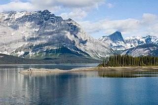
Peter Lougheed Provincial Park is in Kananaskis Country about 90 kilometres (56 mi) west of Calgary, along the Kananaskis Trail in Alberta, Canada.

Pilot Mountain is a mountain in the Bow River valley of Banff National Park in Alberta, Canada. It is located southeast of Redearth Creek and directly west of the Trans-Canada Highway.
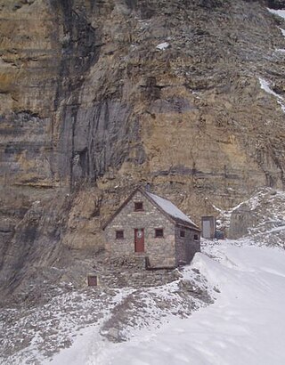
The Abbot Pass hut was an alpine hut located at an altitude of 2,925 metres (9,596 ft) in Abbot Pass in the Rocky Mountains in Alberta, Canada. It was nestled between Mount Victoria and Mount Lefroy, straddling the Great Divide, which, in this region, defines the boundary between Banff National Park in Alberta and Yoho National Park in British Columbia. While close to the border, the hut lay entirely in Banff National Park, and was the second-highest permanently habitable structure in Canada. The hut was maintained by the Alpine Club of Canada.

Mount Arethusa is a mountain located in the Canadian Rockies of Alberta, Canada.

Storm Mountain is a mountain in Alberta's Rockies, Canada.

Ptarmigan Cirque is the cirque between Mount Arethusa and Mount Rae at the Highwood Pass in Kananaskis Country, Alberta, Canada.

Ha Ling Peak is a peak at the northwestern end of Ehagay Nakoda — a mountain located immediately south of the town of Canmore just east of the Spray Lakes road in Alberta's Canadian Rockies. It was previously named Chinaman's Peak but the name was changed to be less offensive. It was the subject of a 2018 CBC Documentary titled 'Ha Ling Peak' that follows the controversy and renaming of the mountain.
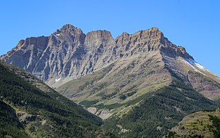
Mount Blakiston is a mountain in the southwestern corner of Alberta, Canada and the highest point within Waterton Lakes National Park. The mountain is situated in the Clark Range, north of Lineham Creek and south of Blakiston Creek. Blakiston's closest neighbours include Mount Hawkins 2,685 m (8,809 ft) directly to the west along a connecting ridge and Mount Lineham 2,728 m (8,950 ft) to the south.
Highwood Pass is a mountain pass in Kananaskis Country, Alberta, Canada. It lies west of Mount Rae and Mount Arethusa of the Misty Range, south of Elbow Pass. It lies within the Peter Lougheed Provincial Park on Alberta Highway 40. The Highwood River originates in the pass.

Gap Mountain is a 2,675-metre (8,776-foot) mountain summit located at the southern end of the Opal Range in the Canadian Rockies of Alberta, Canada. The nearest higher neighbor is Elpoca Mountain, 2 km (1.2 mi) to the east. Gap Mountain is situated 5 km (3.1 mi) south of Mount Wintour, within Peter Lougheed Provincial Park. Gap Mountain is a conspicuous peak seen from Alberta Highway 40 at Highwood Pass. It is a popular climbing destination because it offers exposed scrambling on its eastern flanks with excellent summit views of Kananaskis Country.

Mount Smuts is a 2,938-metre (9,639-foot) mountain summit located in the Canadian Rockies of Alberta, Canada. It is set in the Spray Valley near the northern end of the Spray Mountains range. It is situated on the common boundary shared by Peter Lougheed Provincial Park with Banff National Park. Mount Smuts is not visible from any road in Banff Park, however it can be seen from Alberta Highway 742, also known as Smith-Dorrien/Spray Trail in Kananaskis Country. Mount Smuts' nearest higher neighbor is Mount Birdwood, 2.8 km (1.7 mi) to the south-southeast.


