The 20 metres (66ft)-thick formation crops out in a narrow irregular band in some of the creeks in southern Maryland, and on the southern side of the Potomac River in northern Virginia. The formation was divided into two members by Clark and Martin in 1901; the Potapaco and Woodstock, representing different phases in the basin history. The lower Potapaco Member is much more clayey, described as marl, than the upper Woodstock Member, which is probably characteristic of less storm influences in the shallow shelf sediments.
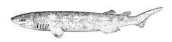
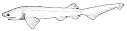
The formation has provided a wealth of fossils of mainly fish, but also mammals, reptiles, birds and flora. The presence of the sharks Otodus obliquus and Otodus aksuaticus, as well as various other shark and ray species are notable. Crocodylian, snake, turtle, mammal, and bird remains have all been found in the Nanjemoy Formation.[1]
The Nanjemoy Formation was defined by Clark and Martin in 1901, as part of the mapping by the Maryland Geological Survey. The Nanjemoy Formation was divided into two members, the lower or Potapaco, and the upper or Woodstock. The main lithologic distinction is that the lower part of the Nanjemoy is much more clayey than the upper part. In the subsurface, the distinction between the members is less evident than in outcrops, especially in Maryland, so the formation has been left undivided.[5]
In the outcrops along the Potomac River near Popes Creek, the contact between the Woodstock and Potapaco at about 10 feet (3.0m) above the water level.[5]
Extent
FS
Ws
Nanjemoy Formation (Virginia)
NC
Nanjemoy Formation (Maryland)
Notable sites of the Nanjemoy Formation in the Potomac River basin in northeastern Virginia and western Maryland NC - Nanjemoy Creek, Ws - Woodstock, FS - Fisher/Sullivan site
The geologic map of the Washington West 30' × 60' Quadrangle (containing Maryland, Virginia, and Washington D.C.) maps out the Nanjemoy Formation, represented as Tn, as restricted to the southeastern side of the Potomac Basin.[6] In his thesis, Scott (2005) included a map showing the thin bands of outcrops of both the underlying Marlboro Clay and the Nanjemoy Formation, restricted to the many creeks feeding the Chesapeake Bay.[7] The Nanjemoy Formation (Eocene), the Marlboro Clay (Paleocene), and the Aquia Formation (Paleocene) are present in the westernmost part of the Potomac channel.[8] The outcrop area of the formation is designated Nanjemoy Wildlife Management Area.
Geology
The Nanjemoy Formation is represented by the orange Paleo-Eocene surrounding the Potomac River
Geologically, the area of deposition of the Nanjemoy Formation is part of the Atlantic coastal plain province. The depositional environment of the Nanjemoy Formation is mostly shallow shelf. The more clayey beds suggest an area or time of quiet water, not affected by waves, tides, or current activity; intercalated sandier zones may reflect the higher energy of waves or currents during episodic storms. Its regional dip is eastward at 15–20ft per mile (3-3.5 m/km).[5]
The upper surface reaches an elevation of about 50 metres (160ft) and is overlain in most places by the Calvert Formation (Tc). The unit is present only in the southeastern part of the map area of Washington D.C., and it reaches a maximum thickness of about 20 metres (66ft).[6]
Petrology
The formation comprises glauconiticquartzsand, dark-grayish-green to olive-black (tan to orange where weathered), fine to medium-grained; and dark-greenish-gray siltyclay. In places, the sand is very muddy or contains many small quartz pebbles, and the clay is silty or sandy. Both lithologies contain richly fossiliferous beds including abundant mollusk shells.[6]
Sand, dominantly quartz, fine-grained, well sorted, micaceous, glauconitic, medium-brown, spa$e wood fragments present and molds and casts of shells
1
Sand, dominantly quartz, dominantly fine-grained but with abundant rounded grains of medium- to coarse-grained quartz and scattered rounded quartz granules and pebbles to 1cm (0.39in) in diameter, glauconitic, medium-brown, contains abundant shell casts of Venericardia potapacoensis and abundant teeth and bones
Sand, dominantly quartz, very fine- to fine-grained, bioturbated and massive, glauconitic, medium-brownish- gray, scattered wood fragments throughout and scattered molds and casts of shells, upper foot bioturbated and burrows filled with matrix from above bed, basal foot contains abundant medium- to coarse-grains and is more glauconitic than sediments above
Clay, silty, finely micaceous, greasy, sticky, lightgray, upper two feet intensely burrowed and burrows filled with matrix from bed above
8
Total section exposed
26
Paleoecology
The floral and faunal assemblage of the Nanjemoy Formation is diverse and provides an insight into the paleobiological and paleoclimatological environment of the early Eocene. Fossils of bivalves, sharks, rays, actinopterygian fishes, reptiles, birds and mammals, and of fruits and seeds are common in the Potapaco Member. More than 2000 vertebrate coprolites from the Potapaco Member at the Fisher/Sullivan Site in Virginia were analyzed by Dentzien Dias et al. (2019). The chemical composition (phosphatic), inclusions and morphology suggest that only carnivorous scats were preserved.[10]
All Nanjemoy coprolites were produced by fishes, namely carcharhiniform & lamniform sharks, probably the genus Carcharias. Other morphotypes were produced by actinopterygian fishes. The surface marks and the lack of flatness on most coprolites suggests early lithification of the Potapaco Member.[10]
Brezina immediately realized that the site was exceptional, because it yielded numerous shark teeth and other vertebrate remains from the sands and gravels in the unnamed tributary. Brezina notified other members of the Maryland Geological Society, and together members of the MGS began to screen stream sediments at the site for more shark teeth and other remains. It soon became apparent, from the types of teeth that were being found and from the color and texture of the sediments in the banks of the creek, that the fossils were being reworked from glauconitic ("greensand") horizons of the Lower Tertiary (Paleocene-Eocene) Pamunkey Group.[18]
Because the Pamunkey Group previously had yielded only sparse vertebrate remains, it seemed reasonable to suspect that this locality was scientifically important.[18]
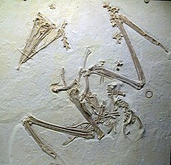
In addition, several indeterminate birds are also known, such as a very large bird the size of a sandhill crane, known only from a single pedal phalanx.[21][22]
The paleoichthyofauna of this formation shares close similarities with better-preserved fossils of concurrent lagerstatte from Europe, most notably the London Clay and Monte Bolca.[26]
Lyttle, Peter T.; Aleinikoff, John N.; Burton, William C.; Crider Jr., E. Allen; Drake Jr., Avery A.; Froelich, Albert J.; Wright Horton Jr., J.; Kasselas, Gregorios; Mixon, Lucy McCartan, Arthur E. Nelson, Wayne L. Newell, Louis Pavlides, David S. Powars, C. Scott Southworth, and Robert E. Weems, Robert B. (2017). "Geologic Map of the Washington West 30' × 60' Quadrangle, Maryland, Virginia, and Washington D.C."(PDF). USGS: 1. Retrieved 2020-03-07.{{cite journal}}: Cite journal requires |journal= (help)CS1 maint: multiple names: authors list (link)
Scott, Mitchell Louis (2005). Mapping and Characterization of the Marlboro Clay formation (M.Sc. thesis). University of Maryland. pp.1–115.
Paleontology publications
Dentzien Dias, Paula; Hunt, Adrian P.; Lucas, Spencer G.; Francischini, Heitor; Gulotta Sr., Marco N. (2019). "Fish coprolites from the Nanjemoy Formation, Lower Eocene, Virginia, USA". Geological Society of America, Abstracts with Programs. 51: 1.
R. E. Weems. 1985. Vertebrate biozones of the Pamunkey Group (Paleocene and Eocene, Maryland and Virginia). Stratigraphy and paleontology of the outcropping Tertiary beds in the Pamunkey River region, central Virginia Coastal Plain—Guidebook for Atlantic Coastal Plain Geological Association 1984 field Trip: Atlantic Coastal Plain Geological Association 198-209
R. Weems and S. Horman. 1983. Teleost fish remains (Osteoglossidae, Blochiidae, Scombridae, Triodontidae, Diodontidae) from the Lower Eocene Nanjemoy Formation of Maryland. Proceedings of The Biological Society of Washington 96(1):38-49
K. V. Palmer and D. C. Brann. 1965. Catalogue of the Paleocene and Eocene molluscs of the southern and eastern United States. Part 1. Pelecypoda, Amphineura, Peteropoda, Scaphopoda and Cephalopoda. Bulletins of American Paleontology 48:1-471
S.F. Blake. 1941. Note on a vertebra of Palaeophis from the Eocene of Maryland. Journal of the Washington Academy of Sciences 31(12):501-503
W. B. Clark and G. C. Martin. 1901. Mollusca. Maryland Geological Survey, Eocene 122-203
C. R. Eastman. 1901. Pisces. Maryland Geological Survey Eocene 98-115
W. B. Clark. 1895. Contributions to the Eocene fauna of the Middle Atlantic slope. Johns Hopkins University Circulars 15(121):3-6
This page is based on this Wikipedia article Text is available under the CC BY-SA 4.0 license; additional terms may apply. Images, videos and audio are available under their respective licenses.