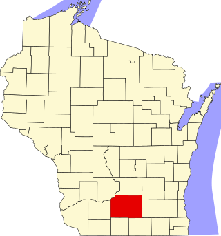
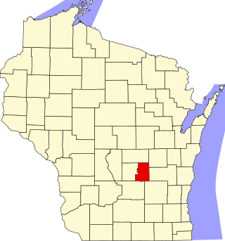
This is intended to be a complete list of the properties and districts on the National Register of Historic Places in Kenosha County, Wisconsin, United States. Latitude and longitude coordinates are provided for many National Register properties and districts; these locations may be seen together in a map.[1]
There are 29 properties and districts listed on the National Register in the county. Another two properties were once listed but have been removed. All but four of these are located inside the county seat, Kenosha, Wisconsin.
Prehistoric site occupied from Paleo-Indian to historic times. The remains of at least 5 adults have been found at the site with copper items including a tubular bead and an awl, all stained with red ochre. A slate gorget was found apart from the burials, and various points and ceramic fragments.[6]
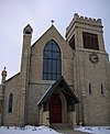
Neogothic-style Unitarian church built in 1907. Bought by the city in 1926 to become a children's library, then reclaimed as a Unitarian church in 1993.
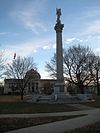
Set aside in 1838 to be a town common, the public area has evolved into a city park "romantically" landscaped by Ossian Cole Simonds and containing a library and war memorial designed by Daniel Burnham.
Another archeological site on what was the plain of Glacial Lake Chicago, which has produced heat-treated points, chipped stone, and bone fragments similar to Chesrow. Occupation could have been from 4000 to 12400 BP.[9]
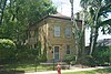
2.5-story brick mansion with ballroom, servants' quarters, and formal garden, designed by Pond and Pond and built in 1926 for James E. Wilson, an executive of Nash Motors. Later the residence of the headmasters of Kemper Hall.[10][11]
2-story cream brick house built in 1842. There in 1850 John MacCaffary drowned his wife Bridget in a backyard cistern. The following year he was convicted of murder. His botched hanging gave the final push toward abolition of the death penalty in Wisconsin.[12][13]
95-foot steel diesel-powered yacht built in 1916 by Harlan and Hollingsworth of Wilmington, Delaware. Sank in 1928 after hitting something in the middle of the night 12 miles east of Kenosha. Now sits 195 feet below the surface.
Public dressing rooms and ballroom along Lake Michigan, designed by Christian Borggren in an unusual assortment of styles and constructed in the late 1930s using reclaimed materials and WPA assistance.
Factory that manufactured metal springs, started by the Windsor Spring Company in 1900. Later the Vincent-McCall Company expanded the factory and the product line to include mattresses, metal lawn furniture, and steel berths and bunks during WWII.[15]
Tudor Revival-styled clubhouse for a public golf course, designed by Hugo Bothe and completed in 1936 with WPA assistance, built partly with reclaimed materials.[16][17]
Greek Revival-styled house built by David Warren in 1848, with exterior walls carefully veneered with cobblestones laid in stripes and with brick quoins on the corners.[18][19]
Lone effigy of a water spirit. The curvature of the tail is unusual in effigy mounds.[21] Photographed from a plane in 1927, it was only the second known instance of aerial photography for archaeological purposes in the U.S.[22]
204-foot iron package steamer built in 1881 - the first iron craft on the Great Lakes with a double bottom. Served as a hospital ship in WWI. Sank in a storm in October 1929.
This is a list of the National Register of Historic Places listings in Dane County, Wisconsin. It aims to provide a comprehensive listing of buildings, sites, structures, districts, and objects in Dane County, Wisconsin listed on the National Register of Historic Places.
This is a list of the National Register of Historic Places listings in Jefferson County, Wisconsin. It is intended to provide a comprehensive listing of entries in the National Register of Historic Places that are located in Jefferson County, Wisconsin. The locations of National Register properties for which the latitude and longitude coordinates are included below may be seen in a map.
This is a list of the National Register of Historic Places listings in Winnebago County, Wisconsin.
This is a list of the National Register of Historic Places listings in Grant County, Wisconsin. It is intended to provide a comprehensive listing of entries in the National Register of Historic Places that are located in Grant County, Wisconsin. The locations of National Register properties for which the latitude and longitude coordinates are included below may be seen in a map.
This is a list of the National Register of Historic Places listings in Ozaukee County, Wisconsin. It is intended to provide a comprehensive listing of entries in the National Register of Historic Places that are located in Ozaukee County, Wisconsin. The locations of National Register properties for which the latitude and longitude coordinates are included below may be seen in a map.
This is a list of the National Register of Historic Places listings in Racine County, Wisconsin. It is intended to provide a comprehensive listing of entries in the National Register of Historic Places that are located in Racine County, Wisconsin. The locations of National Register properties for which the latitude and longitude coordinates are included below may be seen in a map.
This is a list of the National Register of Historic Places listings in Sheboygan County, Wisconsin. It is intended to provide a comprehensive listing of entries in the National Register of Historic Places that are located in Sheboygan County, Wisconsin. The locations of National Register properties for which the latitude and longitude coordinates are included below may be seen in a map.
This is a list of the National Register of Historic Places listings in Walworth County, Wisconsin. It is intended to provide a comprehensive listing of entries in the National Register of Historic Places that are located in Walworth County, Wisconsin. The locations of National Register properties for which the latitude and longitude coordinates are included below may be seen in a map.
This is a list of the National Register of Historic Places listings in Crawford County, Wisconsin. It is intended to provide a comprehensive listing of entries in the National Register of Historic Places that are located in Crawford County, Wisconsin. The locations of National Register properties for which the latitude and longitude coordinates are included below may be seen in a map.
This is a list of the National Register of Historic Places listings in Washington County, Wisconsin. It is intended to provide a comprehensive listing of entries in the National Register of Historic Places that are located in Washington County, Wisconsin. The locations of National Register properties for which the latitude and longitude coordinates are included below may be seen in a map.
This is a list of the National Register of Historic Places listings in Ashland County, Wisconsin. It is intended to provide a comprehensive listing of entries in the National Register of Historic Places that are located in Ashland County, Wisconsin. The locations of National Register properties for which the latitude and longitude coordinates are included below may be seen in a map.
This is a list of the National Register of Historic Places listings in Manitowoc County, Wisconsin. It is intended to provide a comprehensive listing of entries in the National Register of Historic Places that are located in Manitowoc County, Wisconsin. The locations of National Register properties for which the latitude and longitude coordinates are included below may be seen in a map.
This is a list of the National Register of Historic Places listings in Portage County, Wisconsin. It is intended to provide a comprehensive listing of entries in the National Register of Historic Places that are located in Portage County, Wisconsin. The locations of National Register properties for which the latitude and longitude coordinates are included below may be seen in a map.
This is a list of the National Register of Historic Places listings in Chippewa County, Wisconsin. It is intended to provide a comprehensive listing of entries in the National Register of Historic Places that are located in Chippewa County, Wisconsin. The locations of National Register properties for which the latitude and longitude coordinates are included below may be seen in a map.
This is a list of the National Register of Historic Places listings in Waushara County, Wisconsin. It is intended to provide a comprehensive listing of entries in the National Register of Historic Places that are located in Waushara County, Wisconsin. The locations of National Register properties for which the latitude and longitude coordinates are included below may be seen in a map.
This is a list of the National Register of Historic Places listings in Green Lake County, Wisconsin. It is intended to provide a comprehensive listing of entries in the National Register of Historic Places that are located in Green Lake County, Wisconsin. The locations of National Register properties for which the latitude and longitude coordinates are included below may be seen in a map.
This is a list of the National Register of Historic Places listings in Calumet County, Wisconsin. It is intended to provide a comprehensive listing of entries in the National Register of Historic Places that are located in Calumet County, Wisconsin. The locations of National Register properties for which the latitude and longitude coordinates are included below may be seen in a map.
This is a list of the National Register of Historic Places listings in Wood County, Wisconsin. It is intended to provide a comprehensive listing of entries in the National Register of Historic Places that are located in Wood County, Wisconsin. The locations of National Register properties for which the latitude and longitude coordinates are included below may be seen in a map.
This is a list of the National Register of Historic Places listings in Dunn County, Wisconsin. It is intended to provide a comprehensive listing of entries in the National Register of Historic Places that are located in Dunn County, Wisconsin. The locations of National Register properties for which the latitude and longitude coordinates are included below may be seen in a map.
This is a list of the National Register of Historic Places listings in Sawyer County, Wisconsin. It is intended to provide a comprehensive listing of entries in the National Register of Historic Places that are located in Sawyer County, Wisconsin. The locations of National Register properties for which the latitude and longitude coordinates are included below may be seen in a map.
References
↑ The latitude and longitude information provided in this table was derived originally from the National Register Information System, which has been found to be fairly accurate for about 99% of listings. Some locations in this table may have been corrected to current GPS standards.
1 2 Numbers represent an alphabetical ordering by significant words. Various colorings, defined here, differentiate National Historic Landmarks and historic districts from other NRHP buildings, structures, sites or objects.
↑ The eight-digit number below each date is the number assigned to each location in the National Register Information System database, which can be viewed by clicking the number.
↑ David F. Overstreet; Larry Doebert; Gary W. Henschel; Phil Sander; David Wasion (1996). "Two Red Ocher Mortuary Contexts from Southeastern Wisconsin - the Henschel Site (47 SB 29), Sheboygan County and the Barnes Creek Site (47 KN 41), Kenosha County". The Wisconsin Archeologist. 77 (1): 37–40, 44–45.
↑ "Development, Archaeology Collide on a Muddy Field". Milwaukee Journal 1993-04-11: B3.
↑ Overstreet, David F. (1998). "Late Pleistocene Geochronology and the PaleoIndian Penetration of the Southwestern Lake Michigan Basin". The Wisconsin Archeologist. 79 (1): 34–39.
↑ Clifton E. Peterson, M.D.; Diane H. Filipowicz (September 1979). "The Manor House". NRHP Inventory-Nomination Form. US Dept. of the Interior. National Park Service. Retrieved 2018-06-21. With one photo.
↑ Marlene Rockmore; David A. Donath (1976-09-29). "McCaffary, John, House". NRHP Inventory-Nomination Form. US Dept. of the Interior. National Park Service. Retrieved 2018-06-21. With one photo.
↑ Carol Lohry Cartwright (2002-09-05). "Washington Park Clubhouse". NRHP Inventory-Nomination Form. US Dept. of the Interior. National Park Service. Retrieved 2018-07-03. With 12 photos.
↑ Ellen Threinen; Charlene Engel (1974-08-15). "Weed, Justin, House". NRHP Inventory-Nomination Form. US Dept. of the Interior. National Park Service. Retrieved 2018-07-03.
↑ Brown, Charles E. "An Airplane Photograph of an Indian Effigy Mound." The Wisconsin Archaeologist 6 (1927): 105-110.
↑ Location given in Kohl, Cris (2001). The Great Lakes Diving Guide. West Chicago, Ill.: Seawolf Communications, Inc. NRIS lists site as "address restricted".
↑ "Alford Park Warehouse". Architecture and History Inventory. Wisconsin Historic Society. Retrieved 2018-07-03.
↑ "Alford Park Warehouse". National or State Register. Wisconsin Historic Society. Retrieved 2018-07-03.
↑ "Kenosha High School". Architecture and History Inventory. Wisconsin Historic Society. Retrieved 2018-07-03.
This page is based on this Wikipedia article Text is available under the CC BY-SA 4.0 license; additional terms may apply. Images, videos and audio are available under their respective licenses.