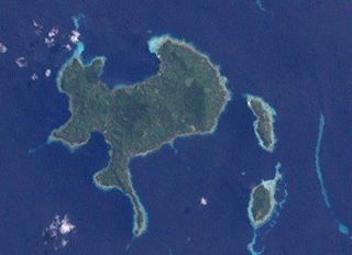
The Obstruction Islands are an archipelago east of New Guinea island, located within Milne Bay Province in the southeastern region of Papua New Guinea.
The Obstruction Islands are an archipelago east of New Guinea island, located within Milne Bay Province in the southeastern region of Papua New Guinea.
The islands are located between the Eastern Cape of New Guinea and Nuakata Island. They received the name Obstruction Islands because they block the passage between Nuakata Island and the mainland of eastern New Guinea island.
The archipelago administratively belongs to the Maramatana Rural LLG (Local Level Government) Area within the Alotau District of Milne Bay Province.
The larger islands of the archipelago are:
In the 2000 census, the Obstruction Islands group had a population of 231 inhabitants, with 180 on Hibwa, and 51 on Lelei Gana/Pahilele.

Milne Bay is a province of Papua New Guinea. Its capital is Alotau. The province covers 14,345 km2 of land and 252,990 km2 of sea, within the province there are more than 600 islands, about 160 of which are inhabited. The province has about 276,000 inhabitants, speaking about 48 languages, most of which belong to the Eastern Malayo-Polynesian branch of the Austronesian language family. Economically the province is dependent upon tourism, oil palm, and gold mining on Misima Island; in addition to these larger industries there are many small-scale village projects in cocoa and copra cultivation. The World War II Battle of Milne Bay took place in the province.

Normanby Island is a volcanic, 1,000-square-kilometre (390 sq mi), L-shaped and mountainous island, as well as the southernmost island in the D'Entrecasteaux Islands group. It is part of Milne Bay Province, Papua New Guinea. The island has an irregular and elongated shape measuring 73km in length (northwest-southeast).

Goodenough Island in the Solomon Sea, also known as Nidula Island, is the westernmost of the three large islands of the D'Entrecasteaux Islands in Milne Bay Province of Papua New Guinea. It lies to the east of mainland New Guinea and southwest of the Trobriand Islands. It is roughly circular in shape, measuring 39 by 26 kilometres with an area of 687 square kilometres (265 sq mi) and a shoreline of 116 kilometres (72 mi). From a coastal belt varying in width from 2 to 10 kilometres in width, the island rises sharply to the summit of Mount Vineuo, 2,536 metres (8,320 ft) above sea level, making it one of the most precipitous islands in the world. The small outlier Wagifa Island lies to the south-east of the island, and is included within Goodenough's administration.

Samarai is an island and former administrative capital in Milne Bay Province, Papua New Guinea.
The Dart Reefs is a group of reefs in the central area of the Ward Hunt Strait in Milne Bay Province of southeastern Papua New Guinea.
Nuakata Island is a small, mountainous island in the Goschen Strait south of Normanby Island and east of East Cape. It is part of Milne Bay Province in southeastern Papua New Guinea. Mount Tanorabwa is the highest point on the island at 1,072 feet (327 m).
Hemenahei Island is an island in Papua New Guinea, part of the Calvados Chain within the Louisiade Archipelago. It is located to toward the eastern end of the Calvados Chain, in the Louisiade Archipelago, in the Milne Bay Province, between Pana Tinani in the East and Pana Wina in the West.

New Guinea is the world's second-largest island, with an area of 785,753 km2 (303,381 sq mi). Located in Melanesia in the southwestern Pacific Ocean, the island is separated from Australia by the 150-kilometre wide Torres Strait, though both landmasses lie on the same continental shelf, and were united during episodes of low sea level in the Pleistocene glaciations as the combined landmass of Sahul. Numerous smaller islands are located to the west and east. The island's name was given by Spanish explorer Yñigo Ortiz de Retez during his maritime expedition of 1545 due to the resemblance of the indigenous peoples of the island to those in the African region of Guinea.

HMAS Ladava is a former Royal Australian Navy (RAN) base that was located at Milne Bay in Papua New Guinea.

The Duchateau Islands are an island group in the Coral Sea, belonging to Papua New Guinea. They lie to the east of Panarairai Island in the Louisiade Archipelago.
The Conflict Group is an atoll in Papua New Guinea. The group was sighted in 1879 by HMS Cormorant, by moonlight; it was named in 1880 by Bower, captain of HMS Conflict. Irai Island is the center of population of the group.
Lunn Island is a solitary island of Papua New Guinea in the Solomon Sea, belonging to the Louisiade Archipelago. It belongs to Milne Bay Province, to the ward of Conflict Group and is located between the Engineer Group, which is 8.3 kilometres to the west, and the Torlesse Islands, which are 18.3 kilometres to the east. The Deboyne Islands are another 22 kilometres eastward.
The Renard Islands are an archipelago in the Solomon Sea. Administratively they belong to Milne Bay Province in the southeastern region of Papua New Guinea.
Utian Island, also known as Brooker Island, is an island in Papua New Guinea, part of the Calvados Chain within the Louisiade Archipelago. It is located at the western end of the Calvados Chain, in the Louisiade Archipelago, in the Milne Bay Province.
The Montemont Islands are an island group in the Coral Sea, belonging to Papua New Guinea. They lie to the east of Panarairai Island in the Louisiade Archipelago.

The Jomard Islands are an uninhabited island group in the Coral Sea, belonging to Papua New Guinea, It lies to the east of Montemont Islands in the Louisiade Archipelago.

The Engineer Islands are an archipelago in the Solomon Sea belonging to Papua New-Guinea.
Mekinley Island is an island north of Sariba Island, and on the eastern side of China Strait, in Milne Bay Province, Papua New Guinea.

The Samarai Islands archipelago, part of the larger Louisiade Archipelago, is located 50 kilometres (31 mi) southeast of mainland New Guinea island, within the nation of Papua New Guinea.
Naval Base Milne Bay, also called Naval Advance Base Milne Bay, was new major United States Navy sea and airbase base built on Milne Bay in Milne Bay Province in south-eastern Papua New Guinea. By spring 1943, the build up of the US Navy to support the Pacific War had caused overcrowding at the ports on the east coast of Australia. To help, Seabees departed Naval Base Brisbane on June 19, 1943 to set up a new base in Milne Bay. Naval Base Milne Bay headquarters was at Ladava Navy Base. The Royal Australian Navy already had a small base in Milne Bay: HMAS Ladava. Australians were able to defend and keep Milne Bay in the Battle of Milne Bay in 1942. Naval Base Milne Bay was built during World War II to support the many ships and aircraft fighting and patrolling in the South West Pacific theatre of war. Ladava Navy Base provided a large protective US Navy fleet anchorage at Gahora Bay next to Ladava. At Naval Base Milne Bay, Seabees built a large Naval facility.
10°16′S150°56′E / 10.267°S 150.933°E
Islands of Papua New Guinea | |
|---|---|
| Bismarck Archipelago | |
| Louisiade Archipelago | |
| North Solomon Islands | |
| | This Milne Bay Province geography article is a stub. You can help Wikipedia by expanding it. |