Pocopson, Pennsylvania

Last updated
Pocopson, Pennsylvania
Unincorporated community
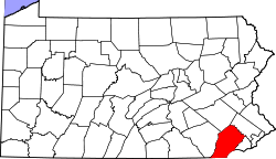
USA Pennsylvania location map.svg
Red pog.svg
Pocopson
Coordinates: 39°54′1″N75°37′33″W / 39.90028°N 75.62583°W / 39.90028; -75.62583 Coordinates: 39°54′1″N75°37′33″W / 39.90028°N 75.62583°W / 39.90028; -75.62583
Country United States
State Pennsylvania
County Chester
Township Pocopson
Elevation
180 ft (50 m)
Time zone UTC-5 (Eastern (EST))
  Summer (DST) UTC-4 (EDT)
ZIP code
19366
Area code(s) 610 and 484
GNIS feature ID1204428 [1]

Pocopson is an unincorporated community in Pocopson Township in Chester County, Pennsylvania, United States. Pocopson is located at the intersection of Pennsylvania Route 926 and Pocopson Road. [2]

Contents

Former train station

Pocopson was once served by a train station that opened in 1890. [3]

Related Research Articles

<span class="mw-page-title-main">Chester County, Pennsylvania</span> County in Pennsylvania, United States

Chester County, colloquially known as Chesco, is a county in the Commonwealth of Pennsylvania. It is located in the Delaware Valley region, located in the southeastern part of the state. As of the 2020 census, the population was 534,413, increasing by 7.1% from 498,886 in 2010. The county seat and most populated municipality is West Chester. Chester County was one of the three original Pennsylvania counties created by William Penn in 1682. It was named for Chester, England.

<span class="mw-page-title-main">Birmingham Township, Chester County, Pennsylvania</span> Township in Pennsylvania, United States

Birmingham Township is a township in Chester County, Pennsylvania. The population was 4,085 at the 2020 census.

<span class="mw-page-title-main">East Bradford Township, Chester County, Pennsylvania</span> Township in Pennsylvania, United States

East Bradford Township is a township in Chester County, Pennsylvania, United States. The population was 10,308 at the 2020 census.

<span class="mw-page-title-main">East Marlborough Township, Chester County, Pennsylvania</span> Township in Pennsylvania, United States

East Marlborough Township is a township in Chester County, Pennsylvania, United States. The population was 7,026 at the 2010 census. East Marlborough and West Marlborough townships were carved out of the larger Marlborough Township in 1729. The township is home to many Penn Oak trees, trees that were in existence when William Penn explored the area.

<span class="mw-page-title-main">Pocopson Township, Chester County, Pennsylvania</span> Township in Pennsylvania, United States

Pocopson Township is a township in Chester County, Pennsylvania, United States. The population was 4,582 at the 2010 census.

<span class="mw-page-title-main">West Bradford Township, Chester County, Pennsylvania</span> Township in Pennsylvania, United States

West Bradford Township is a township in Chester County, Pennsylvania, United States. The population was 12,376 at the 2010 census.

<span class="mw-page-title-main">Concord Township, Delaware County, Pennsylvania</span> Township in Pennsylvania, United States

Concord Township is a township in Delaware County, Pennsylvania, United States. The population was 17,231 at the 2010 census. It contains the unincorporated communities of Concordville and Glen Mills.

<span class="mw-page-title-main">Pennsylvania Route 52</span> State highway in Chester County, Pennsylvania, US

Pennsylvania Route 52 is a 11.8-mile-long (19.0 km) state highway located in southeast Pennsylvania. The southern terminus of the route is at the Pennsylvania-Delaware state line near Kennett Square, where the road continues as Delaware Route 52. The northern terminus is at U.S. Route 322 Business in West Chester. Near the Kennett Township community of Longwood, it has about a 1-mile (1.6 km) wrong-way concurrency with US 1. PA 52 passes through suburban and rural areas along its route.

<span class="mw-page-title-main">Pennsylvania Route 926</span> State highway in Pennsylvania, US

Pennsylvania Route 926 is a 26.2-mile-long (42.2 km) state route located west of Philadelphia in Chester County, Pennsylvania. The western terminus of the route is at PA 10 in Upper Oxford Township. The eastern terminus is at PA 3 in the Philadelphia suburb of Willistown Township. The route is known as Street Road for its entire length. For 0.9 miles (1.4 km), PA 926 runs along the county line between Delaware and Chester counties. The route passes through a mix of suburban and rural areas along its extent. PA 926 is two lanes and undivided its entire length.

<span class="mw-page-title-main">Smedley Darlington</span> American politician

Smedley Darlington was an American politician who served as a Republican member of the U.S. House of Representatives for Pennsylvania's 6th congressional district from 1887 to 1891.

<span class="mw-page-title-main">Pennsylvania Route 842</span> State highway in Chester County, Pennsylvania, United States

Pennsylvania Route 842 is a state highway in Chester County, Pennsylvania. The route runs from PA 841 in West Marlborough Township to U.S. Route 322 Business in downtown West Chester. PA 842 runs through rural areas with some development between PA 841 and West Chester as a two-lane undivided road. Along this stretch, the route forms a concurrency with PA 82 in Unionville, where it intersects the western terminus of PA 162. In West Chester, PA 842 is routed along one-way streets. PA 842 was first designated by 1928 between PA 82 in Unionville and US 122/PA 5/PA 62 in West Chester. The route was extended west to PA 841 in 1937.

<span class="mw-page-title-main">East Penn Railroad</span> Railway line in the United States of America

East Penn Railroad is a short-line railroad that operates a number of mostly-unconnected lines in the U.S. states of Pennsylvania and Delaware. Except for two industrial park switching operations, all are former Pennsylvania Railroad or Reading Company lines, abandoned or sold by Conrail or its predecessors.

<span class="mw-page-title-main">Pennsylvania House of Representatives, District 159</span> American legislative district

The 159th Pennsylvania House of Representatives District is located in Delaware County. The 159th District lies in the Southeast part of the state. It has been represented by Carol Kazeem since 2022.

Russellville is an unincorporated community in Upper Oxford Township in Chester County, Pennsylvania, United States. Russellville is located at the intersection of state routes 10 and 896.

<span class="mw-page-title-main">Chatham, Pennsylvania</span> Unincorporated community in Pennsylvania, United States

Chatham is an unincorporated community in London Grove Township in Chester County, Pennsylvania, United States. Chatham is located at the intersection of Pennsylvania Route 41 and Pennsylvania Route 841.

Lenape is an unincorporated community in Pocopson Township in Chester County, Pennsylvania, United States. Lenape is centered on the intersection of Pennsylvania Route 52 and Pocopson Road, west of the Brandywine Creek.

Lewisville is an unincorporated community in Elk Township in Chester County, Pennsylvania, United States. Lewisville is located at the intersection of state routes 472 and 841, just north of the Maryland border.

Lenni is an unincorporated community in Middletown Township in Delaware County, Pennsylvania, United States. Lenni is located at the intersection of Lenni Road and Lungren Road northeast of the Chester Creek.

Darlington Corners is an unincorporated community in Thronbury and Westtown townships in Chester County, Pennsylvania, United States. Darlington Corners is located at the intersection of U.S. Route 202/U.S. Route 322 and Pennsylvania Route 926 south of West Chester.

<span class="mw-page-title-main">Eusebius Barnard</span> American farmer, minister and abolitionist (1802–1865)

Eusebius Barnard was an American farmer and station master on the Underground Railroad in Chester County, Pennsylvania, helping hundreds of fugitive slaves escape to freedom. A minister of the Progressive Friends and founding member of Longwood Meeting House, Barnard championed women’s rights, temperance, and abolition of slavery. A Pennsylvania state historical marker was placed outside his home in Pocopson Township on April 30, 2011.

References

  1. "Pocopson". Geographic Names Information System . United States Geological Survey, United States Department of the Interior.
  2. Chester County, Pennsylvania Highway Map (PDF) (Map). PennDOT. 2012. Archived from the original (PDF) on November 12, 2011. Retrieved August 22, 2013.
  3. "Living History: The vanishing train depot".