Wooster Square is a neighborhood in the city of New Haven, Connecticut to the east of downtown. The name refers to a park square located between Greene Street, Wooster Place, Chapel Street and Academy Street in the center of the neighborhood. Wooster Square is also known as Little Italy: a bastion of Italian American culture and cuisine, and is home to some of New Haven's, best-known pizza eateries, including Frank Pepe Pizzeria Napoletana and Sally's Apizza. The square and much of the neighborhood are included in the Wooster Square Historic District, which was listed on the National Register of Historic Places in 1971.
The Avenues is an affluent neighborhood in Salt Lake City, Utah. It is named after the perfectly gridlike, closely laid out roads called Avenues and Streets. First surveyed in the 1850s, the Avenues became Salt Lake City's first neighborhood. Today, the Avenues neighborhood is generally considered younger, more progressive, and somewhat "artsy" when compared to other neighborhoods. Many young professionals choose to live there due to the culture and easy commute to downtown.. It is also one of the most important strongholds of the Democratic political party in Utah.

The Fan is a district of Richmond, Virginia, so named because of the "fan" shape of the array of streets that extend west from Belvidere Street, on the eastern edge of Monroe Park, westward to Arthur Ashe Boulevard. However, the streets rapidly resemble a grid after they go through what is now Virginia Commonwealth University. The Fan is one of the easterly points of the city's West End section, and is bordered to the north by Broad Street and to the south by VA 195, although the Fan District Association considers the southern border to be the properties abutting the south side of Main Street. The western side is sometimes called the Upper Fan and the eastern side the Lower Fan, though confusingly the Uptown district is located near VCU in the Lower Fan. Many cafes and locally owned restaurants are located here, as well as historic Monument Avenue, a boulevard formerly featuring statuary of the Civil War's Confederate president and generals. The only current statue is a more modern one of tennis icon Arthur Ashe. Development of the Fan district was strongly influenced by the City Beautiful movement of the late 19th century.
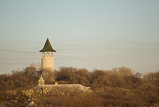
Prospect Park is a historic neighborhood within the University community of the U.S. city of Minneapolis, Minnesota. The area is bounded by the Mississippi River to the south, the City of Saint Paul, Minnesota to the east, the Burlington Northern railroad yard to the north, and the Stadium Village commercial district of the University of Minnesota to the west. The neighborhood is composed of several districts which include the East River Road area. The 1913 Prospect Park Water Tower is a landmark and neighborhood icon.
This article is about the many neighborhoods and districts in the Greater Richmond, Virginia area. Note that this article is an attempt to be inclusive of the broader definitions of the areas which are often considered part of the Greater Richmond Region, based on their urban or suburban character and nature, rather than by strictly political boundaries.

The Kenwood Historic District is a U.S. historic district located in St. Petersburg, Florida. The district was designated on August 4, 2003 and is located immediately west of downtown, bounded by 9th Avenue North, 1st Avenue North, 19th Street North and 34th Street North. It contains 2,203 historic buildings, and Grand Central adjoins the district at its southern boundary.

The Lummus Park Historic District or simply Lummus Park, is on the National Register of Historic Places and a locally historic designated district in Miami, Florida. It is roughly bound by Northwest Fifth Street to the north, Flagler Street to the south, Northwest Third Avenue to the east, and the Miami River to the west. On October 25, 2006, it was added to the U.S. National Register of Historic Places. Lummus Park has some of the oldest structures in Miami, and over the decades, has been able to retain a large part of its early pioneer character.
The Old Dauphin Way Historic District is a historic district in the city of Mobile, Alabama, United States. It was named for Dauphin Way, now known as Dauphin Street, which bisects the center of the district from east to west. The district is roughly bounded by Broad Street on the east, Springhill Avenue on the north, Government Street on the south, and Houston Avenue on the west. Covering 766 acres (3.10 km2) and containing 1466 contributing buildings, Old Dauphin Way is the largest historic district in Mobile.
The North End Historic District is a historic district in Woonsocket, Rhode Island encompassing an affluent residential area developed predominantly between about 1880 and 1930. It is bounded by Harris Avenue on the west, Winter Street on the north, Summer and Prospect Streets to the east, and Spring and Blackstone Streets to the south. It is separated from Woonsockets commercial and industrial heart by a neighborhood of densely populated worker housing. Most of the district's 224 major buildings are of relatively high quality and in good condition, and are reflective of the architectural styles that predominated in the late 19th and early 20th centuries: Queen Anne Victorian, Colonial Revival, and Tudor Revival forms and styles are the most common seen.

The Elmwood Historic District encompasses two large residential sections of the Elmwood neighborhood of Providence, Rhode Island. The Elmwood area was mainly farmland until the mid-19th century, when its development as a residential area began, and these two sections represents well-preserved neighborhoods developed between about 1850 and 1920. The district was listed on the National Register of Historic Places in 1980.

Broadway–Flushing is a historic district and residential subsection of Flushing, Queens, New York City. The neighborhood comprises approximately 2,300 homes. It is located between 155th and 170th Streets to the west and east respectively, and is bounded on the north by Bayside and 29th Avenues, and on the south by Northern Boulevard and Crocheron Avenue. Broadway–Flushing is listed on the National Register of Historic Places.

Mountain View is a Roanoke, Virginia neighborhood located in central Roanoke north of the Roanoke River. It borders the neighborhoods of Norwich on the west, West End on the east, Hurt Park on the north and Raleigh Court and Wasena on the south.

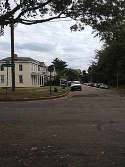
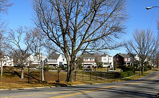
The Branford Point Historic District is a historic district in Branford, Connecticut. It was listed on the National Register of Historic Places in 1988. It includes a significant portion of the Branford Point neighborhood, generally considered to be the area along the west side of the Branford Harbor to the Amtrak railroad tracks. It is bounded on the west by the Short Beach neighborhood, on the north by Branford Center, and on the east by the Branford River. Harbor Street, Maple Avenue, and Stannard Avenue are the main thoroughfares of the neighborhood. In the 2000 Census, Branford Point was included by the U.S. Census Bureau in the Branford Center census-designated place.

The Museum District, alternately known as West of the Boulevard, is a neighborhood in the city of Richmond, Virginia. It is anchored by the contiguous six-block tract of museums along the west side of Boulevard, including the Virginia Museum of Fine Arts and the Virginia Museum of History & Culture, hence the name.
The Bayard Park Neighborhood is a neighborhood in Evansville, Indiana which is bounded by Lincoln Avenue, US Highway 41, Washington Avenue and Garvin Street. The Bayard Park Historic District contains approximately 87 acres including 335 contributing buildings and 1 contributing site within the neighborhood boundaries. It was added to the National Register of Historic Places in 1985. The architecture of residential homes in the neighborhood include quaint 1890s Queen Anne cottages, ground-hugging bungalows, American Fourquares, and high-style Early American and English revival types. The neighborhood also features Evansville's first neighborhood park and the East Branch Library, a Carnegie Library funded by the renowned philanthropist Andrew Carnegie.

The Brookland Park Historic District is a national historic district located at Richmond, Virginia. The district encompasses 1,157 contributing buildings located north of downtown Richmond and Barton Heights. The primarily residential area developed starting in the late-19th century as one of the city's early “streetcar suburbs.” The buildings are in a variety of popular late-19th and early-20th century architectural styles including frame bungalows and American Foursquare. The neighborhood is characterized by frame dwellings with a single-story porch spanning the facade, and either Colonial Revival or Craftsman in style, moderate in scale, with understated materials and stylistic expression. Notable non-residential buildings include the North Side Branch building, Brookland Inn, former A&P Grocery Store, North Side Junior High School, Barack Obama Elementary School, St. Paul's School building (1923), St. Philip's Episcopal Church, First African Baptist Church (1922), and Garland Avenue Baptist Church.
The Battery Court Historic District is a national historic district located at Richmond, Virginia. The district encompasses 549 contributing buildings and 1 contributing site located north of downtown Richmond and west of Barton Heights and Brookland Park. The primarily residential area developed starting in the early-20th century as one of the city's early “streetcar suburbs.” The buildings are in a variety of popular late-19th and early-20th century architectural styles including frame bungalows, American Foursquare, Colonial Revival, Tudor Revival, and Mission Revival. Notable non-residential buildings include the Overbrook Presbyterian Church and Battery Park Christian Church.

The George–Pine–Henry Historic District encompasses a residential area of the village of Bellows Falls, Vermont. Located west of downtown Bellows Falls, the area has a significant concentration of well-preserved late 19th and early 20th-century residences. It was listed on the National Register of Historic Places in 2010.

The Maple Street–Clarks Avenue Historic District encompasses a historic 19th-century immigrant neighborhood of St. Johnsbury, Vermont. Located northwest of the downtown area on a sloping hillside, it consists of tenements and single-family houses built for Irish and French Canadian immigrants, sometimes grouped in ways that facilitated the support of large extended families. The district was listed on the National Register of Historic Places in 1994.

The University Neighborhood Historic District comprises the residential area south of the University of Wyoming in Laramie, Wyoming. The 24-block historic district is bounded on the north by University Avenue, the east by 15th Street, the south by Custer Street, and the west by 6th Street. The neighborhood's period of significance is from 1872 to 1958, a time when the area around the university was developed. Architectural styles in the district are diverse and the neighborhood is almost entirely composed of single-family residences.