Numerous archaeological digs have shown that early Indigenous groups arrived at The Forks site around 6,000 years ago. The digs conducted between 1989 and 1994 discovered several Indigenous camps. Artifacts related to the bison hunt and fishing were unearthed. Evidence showed that Nakoda (Assiniboins), Cree, Anishinaabe (Ojibwa) and Sioux (Dakota) visited the site.[3] Seasonal migration routes from northern forests to southern plains featured the Forks area as a rest stop, and the location became a key transcontinental trade link.[4]
The Assiniboine River has followed its modern course for approximately 700 years. The Assiniboine River formerly met the Red River near the present-day mouth of the La Salle River.[5]
1734–1880
European fur traders arrived at the site and initiated trade with the local peoples, using the Assiniboine people as fur trade middlemen.[4]
Europeans arrived by canoe in 1738. La Vérendrye erected Fort Rouge, the first of a long line of forts and trading posts erected in the area. The Red River Colony and the forts were all established near The Forks. The area remained the hub of the fur trade up until the 1880s. At that time, grain production became Western Canada's principal industry and the main transportation for that industry was rail rather than waterways.[3]
From 1760 to 1821, the Hudson's Bay Company (HBC) and North West Company competed for furs. Both companies used The Forks to store and ship supplies and furs. By 1821, competing fur companies were amalgamated into the HBC.[4]
The Forks Market was formed by joining together the Grand Trunk Pacific Railway stable and the Great Northern Railway stable. What is now the Johnston Terminal was originally known as the National Cartage Building.[3]
The Manitoba Children's Museum is housed in what used to be the Northern Pacific and Manitoba Railway Company's Buildings and Bridges (B & B) Buildings. Union Station is still in operation.[3]
Across the Prairies, the Canadian government began actively promoting immigration, settlement, and railway development in the late 1800s. The Canadian government erected two immigration sheds at The Forks, each accommodating up to 500 people.[3]
The Forks today
On July 24, 1987, the Forks Renewal Corporation (FRC) was incorporated as a wholly-owned subsidiary of the North Portage Development Corporation (NPDC). The objective of FRC was to provide a mechanism for implementing the redevelopment of the former CN East Yards area. The result was The Forks as its known today. (The operations of FRC and NPDC were merged in 1994 to form The Forks North Portage Partnership.)[6]
Following the opening of the Forks National Historic Site in 1989,[2] the Forks became the location of an interpretive park, and later public space for celebrations and recreation, revitalized historic and new buildings containing shops and restaurants, as well as a skateboard park and historic port. The Forks attracts over four million visitors each year.[3]
Facilities
The Forks Market
The food hall at the Forks in downtown Winnipeg, Manitoba. Photo is taken from the second level, looking down on crowded tables of people eating and drinking.Entrance to The Forks Market
Beginning as two adjacent stables for competing rail companies (Grand Trunk Pacific and Great Northern), the horse stalls were joined by a courtyard and bridges, and became what is now known as The Forks Market.[7]
The Forks Market features a six-storey tower with viewing platform,[8] which is accessible by stairs or elevator and features interpretive panels with information on the site's history.
The market also comprises two storeys of vendors selling everything from fresh fruit, bread, meat, and wine to cigars and aromatherapy products to crafts and artworks from 300 local and Canadian artisans.[7]
In mid-2016, the Forks completed a $2.5-million renovation of the food hall into a feature called The Common, including a new beer and wine kiosk.[9]
Outside, located directly in between The Forks Market and Johnston Terminal, The Forks Market Plaza features fountains, canopies, dancing programs, several open performance spaces and patios.[10] In the winter, the Plaza is home to an artificially-cooled skating rink, under a canopy and lights.[10]
Johnston Terminal
Johnston Terminal
The main entrance to Johnston Terminal at the Forks
Former names
National Cartage Building
General information
Address
25 Forks Market Rd, Winnipeg, MB
Completed
1928
Cost
$134,700
Owner
Artis REIT
Technical details
Floor count
4
Design and construction
Main contractor
Carter-Halls-Aldinger Company
Across the courtyard from the Forks Market is the four-storey Johnston Terminal building.
It was constructed in 1928 by Carter-Halls-Aldinger Company, and cost an estimated $134,700.[11][12] Originally named the National Cartage Building, it was built as a warehouse and freight-forwarding facility for the Canadian National Railway (CNR).[13][12]
After a substantial addition in 1930, the warehouse was at the time one of the largest in Winnipeg, containing over 9,300 square metres (100,000sqft) of usable space. It was occupied by National Storage and Cartage, a wholly-owned CNR subsidiary, until 1961, and was leased to the Johnston National Cartage Company (later known as the Johnston Terminals Company) for the next 15 years.
Vacated in 1977, the building was unoccupied until the redevelopment of the site into The Forks as a retail space.[13] The developers, Artis REIT, continue to own and manage Johnston Terminal.[14]
The building is now a municipally-designated historic site, and is now home to a variety of specialty boutiques, stores, offices, and restaurants. The main and second floor tenants are retailers, including The Old Spaghetti Factory; while the third and fourth floors are leased to office tenants.[15] The basement of the building hosts the Johnston Terminal Antique Mall, which has more than 30 consigners and 7,000 square feet (650m2) of new merchandise brought in daily.[16]
Travel Manitoba Visitor Information Centre
Travel Manitoba Visitor Information Centre is the visitor information centre for Manitoba, offering travel counselling and trip planning services. The centre also acts as a meeting point for the "6,000 Years in 60 Minutes!" Parks Canada interpretive program offered throughout the summer months.[17]
Located next to the Oodena Celebration Circle, the Manitoba Children's Museum is a non-profit, charitable children's museum featuring twelve permanent galleries.[18] Originally opened at a different location in 1986, the museum's moved to its current building at the Forks in 1994.[19] The museum is now housed in the former Kinsmen Building, which is the oldest surviving train repair facility in Manitoba, having been built in 1889.[20]
The museum underwent $10 million in renovations in 2011, including the addition of the Buhler Welcome Centre.[19]
The Manitoba Theatre for Young People (MTYP) is a theatre for children and young adults, located at the Canwest Performing Arts Centre (now the Shaw Performing Arts Center) in The Forks.[21] The location provides 28,000 square feet (2,600m2)[22] of space for the theatre to use towards its missions of producing entertaining professional theatre, providing training in theatre and portraying the experience of Canadian children.[23]
MTYP's Theatre School offers Fall, Winter, and Spring sessions, as well as spring break and summer camps, including classes for children as young as three years old.[24] MTYP offers free acting, performing and film training classes to Winnipeg's Indigenous youth between the ages of 12 and 18.[25]
The site for the museum is one of archaeological importance relating to First Nations history.[26]
Inn at the Forks
Inn at the Forks
Inn at the Forks is a five-storey hotel located at the Forks.[27] It has 117 guest rooms and suites, meeting and reception space for up to 200 people, fitness facilities, and features the restaurant Smith and Riverstone Spa.[28] The hotel features natural slate floors in the main lobby, glass vanities in the suite washrooms, heated floors, and a water wall in the spa.[27]
The Inn at the Forks project was the first Canadian application of the "Redi-Maid" system that links ensuite occupancy sensors, lighting and mechanical system controls to staff PDAs with the goal of maximizing energy efficiency. The hotel was completed with a construction cost of $16 million in May 2004.[29]
The Forks features numerous outdoor facilities, sculptures, and landscape features open to the public.
Arctic Glacier Winter Park
Ice skating under the canopy
During winter, the following skating rinks, trails, and snow park structures are erected at the Forks:[31]
The Plaza Skating Rink
An Olympic-sized Skating Rink
Rink under Scotiabank Stage
1.2km of skating trails
The Snowboard Fun Park
The Toboggan Run
Ice skating on the river
In January 2008, the Guinness Book of World Records recognized The Forks as the home of the longest skating rink in the world.[32] The 8.54-kilometre-long River Trail on the Assiniboine River and the Red River is almost 1-kilometre longer than the previous record-holding rink. The 7.8-kilometre long rink on the Rideau Canal in Ottawa, Ontario had lost its World Record title which it had held since 1971. Then in 2008 the rivers beat their own record which made the longest rink go to about 9.3-kilometres. The Rideau Canal still held the record for the "world's largest naturally frozen ice rink" by the Guinness Book of World Records because "its entire length receives daily maintenance such as sweeping, ice thickness checks and there are toilet and recreational facilities along its entire length".[33][34] In 2013, the Assiniboine Credit Union River Trail lost its record to the Lake Windermere Whiteway at Invermere, British Columbia.[35]
The length of the skating trail at The Forks changes each year, depending on river and ice conditions, although a concerted effort is made to make it as long as possible. In the winter of 2010/2011, conditions on The Assiniboine River made it impossible to safely create skating westward, so the path extended instead south on the Red River. Essentially, the water level and the weather at the time of freeze-up will impact the way the ice forms (see frazil ice, for example), how stable it will be, and how smoothly it can be made for skating. Much of the local river ice in Winnipeg in the winter of 2010/2011 was too rough to form a skating surface. There is also a skating trail made overland which is not impacted by river conditions. There are also walking and ski trails running parallel to the skating trail.
Warming Huts: An Art + Architecture Competition on Ice is an open competition endorsed by the Manitoba Association of Architects. Started in 2010, the first iteration of the competition saw five local architects building outdoor structures to protect people from winter weather. In 2011, competition was opened up to international participants and included work by Frank Gehry's firm Gehry Partners.[36][37] The competition has been awarded a Downtown Merit Award from the International Downtown Association.[38]
The Riverwalk is often closed due to river flooding in springtime.[52][53] From the construction of the walkway to the summer of 2011, the walkway has been submerged beyond access for part of the summer for 16 out of 21 years.[54]
The Broadway Promenade is a pedestrian walkway connecting the Esplanade Riel pedestrian bridge to Union Station and Broadway.[57] Designed by Scatliff+Miller+Murray, the design incorporates two pathways which cross the site. One pathway re-established the historic Broadway/Provencher Boulevard connection, and the other is a winding pathway representing pre-European contact era.[58]
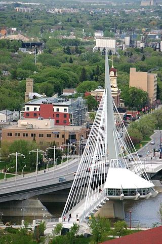
Co-designed by architects Guy Préfontaine and Étienne Gaboury of Gaboury Préfontaine Perry Architects Inc.,[60] Esplanade Riel is the only bridge with a restaurant in North America, and since July 2015 is occupied by Mon Ami Louis.[61] Former leasees include Salisbury House,[62] a local Winnipeg chain restaurant, and Chez Sophie.[63]
CN Stage and Festival Park
The CN Stage is an outdoor stage with adjoining greenspace, built along the Broadway Promenade.[64]
Positioned along the Assiniboine Riverwalk, the historic port offers river vessel docking and rental, as well as access to the Winnipeg Waterways Water Bus and River tours.[67]
During times of flooding Winnipeg Waterways employs a movable ramp and floating dock system that allows it to operate in high water conditions.
Historic Rail Bridge
Built in 1888, the rail bridge was abandoned and eventually converted into a lighted crossing for pedestrians, cyclists and skaters.[68] The mural on the side of the rail bridge is entitled "Jackson Beardy – Woodlands Group of Seven Tribute", and was painted in 2006 for Graffiti Gallery's Winnipeg International Mural Festival. The 30-foot wide and 20-foot tall mural pays tribute to Cree artist Jackson Beardy as well as the other members of the Indian Group of Seven.[69]
Oodena Celebration Circle
Armatures of the Oodena Celebration Circle
Oodena Celebration Circle is a natural shallow amphitheatre located between Johnston's Terminal, the Manitoba Children's Museum, and the Red River Riverwalk. Oodena is Ojibwe for 'centre of the city'. Commissioned in 1993, the site was designed by the firm of Hilderman Thomas Frank Cramm.[70] The location features sculptures, a sundial, interpretive signage, a naked-eye observatory, and a ceremonial fire pit.[71]
The circular amphitheatre is 60 metres (200ft) in diameter and 2.5 metres (8.2ft) deep.[72] The 3 metres (9.8ft) excavation for the site unearthed what is referred to by local archaeologists as "the archaic horizon", a 3,000-year-old layer of soil rich in artifacts.[73]
There are eight unique steel armatures that rest on cobblestone formations surrounding the bowl.[70] Each armature points at a specific constellation, according to dates and times indicated on the panels surrounding the central stage.[70] Sighting rings on the armatures identify specific stars within the constellations.[73] The supporting cobblestone formations bear inscriptions of various legends about the stars their armatures focus upon.[70] The amphitheatre marks the vernal and autumnal equinox and the summer and winter solstices.[72] "The south armature features a shadow rod that casts solstice shadows on ground markers, the west armature is fitted with a wind sculpture, and the northeast armature features an aeolian harp." (Hilderman Thomas Frank Cramm – Oodena Celebration Circle)[70]
The site has been used as a meeting grounds for such varied events as "No Stone Unturned", a free concert in honour of Manitoba's missing and murdered women,[74] as well as the 2011 opening night location for THIN AIR, the Winnipeg International Writers Festival[75] and as the meeting location for Winnipeg's Zombie Walk 2012.[76]
Gardens and orchard
The Forks' Prairie Garden is a 1,900m2 (20,000sqft) garden featuring Manitoba's natural heritage. It was developed in 1999 in partnership with Nature Conservancy of Canada as a demonstration garden, in anticipation of it being a showcase for visitors at the 1999 Pan Am Games. The prairie garden is a natural wild garden with over 10,000 plants in over 150 native plant species, including 38 prairie plants such as prairie crocus, wild iris, bergamot, purple prairie clover, and wild columbine.[77]
The Public Orchard, in collaboration with Winnipeg-CORE,[78][79] contains 61 fruit trees including apple, apricot, cherry, pear, and plum, which the public can pick to eat from when the fruit is ripe. There are as many as 75 fruit bearing shrubs packed with all types of berries to pick from during the summer days. There are also many education sessions through Winnipeg-CORE that are open to the public, as part of The Fork's Target Zero initiative.[80]
In collaboration with Citigrow, the Urban Garden contains vegetables and herbs to be harvested by the Inn at The Forks and integrated into their menu.[81]
Skatepark
The Plaza Skatepark at the Forks
Officially opened 30 June 2006,[82] "The Plaza" is the largest urban skate plaza and bowl complex in Canada.[83] Announced in 2005, it was built with money donated from the J.W. Burns Family Foundation. The skatepark includes a 30,000-square-foot (2,800m2) skate plaza, and an 8,500-square-foot (790m2) 'bowl complex'.[84]
The design features 'skateable' artwork, and is built to tolerate the regular use and enjoyment of skateboarders and cyclists. The park was also designed to integrate into the urban architecture of the city. It was designed by landscape architecture firm van der Zalm + associates inc. of Vancouver, BC with key team members, New Line Skateparks and Scatliff Miller Murray as the local landscape architects.[84]
"Skate Patrol" are experienced skateboarder staff members that tour the park from dawn to dusk to educate skaters on the park's etiquette.[85]
In winter, this area features a small snowboarding facility.[31]
In 2006, the park was visited by professional skateboarder Tony Hawk to shoot scenes for his movie release Secret Skatepark Tour 3.[86]
Landmarks and other features
Rail cars at the ForksThe "Wall Through Time" sculpture
The Alloway Arch, located just east of Union Station, was constructed from the façade of the original Alloway and Champion Bank, which once stood at 362 Main Street and was the largest private bank in Western Canada in its time. One of the bank's owners, William Forbes Alloway, went on to establish The Winnipeg Foundation in 1921.[87]
"Balance of Spirit Within" is a granite stone sculpture weighing approximately 10 tonnes, and is located on the north side of the Forks Historic Rail Bridge.[88]
There are often buskers in and around The Forks. Buskers perform at stations known as "Busk Stops". They are paid by donation, but are prohibited from suggesting donation amounts or requesting contributions. There is an annual competition called the "Scotiabank Busker's Festival" at which it is decided who will be allowed to Busk.[89]
The posts on the canopy between The Forks Market and Johnston Terminal have bands on them to commemorate the peak water levels of major floods.[90] Starting from the bottom of the posts, the bottom marker represents the 1950 flood, the middle marker represents both the 1852 and 1997 floods, and the top the flood of 1826.[90] The flood line markers on one of the posts have historic plaques with information on the floods they represent.[91]
Niimaamaa is a stylized sculpture of a pregnant woman, made by artists KC Adams, Jaimie Isaac, and Val Vint. Created in 2018, the sculpture is made of painted steel, copper, and corten metal. The word niimaamaa is recognized by Cree, Ojibwe, and Métis speakers as 'My mother', and is meant to represent "motherhood, Mother Earth and new beginnings".[92]
The "Peace Meeting" interpretive site is a landscaped resting area along the Broadway Promenade, featuring Indigenous and European elements, notable for having two gigantic Adirondack chairs. The site was created via a grant from The Winnipeg Foundation.[93]
Just outside The Forks Market are two completely restored turn-of-the-century rail cars.[94] One car is for display, while the other is home to "Sugar Mountain Express", a candy store.[95]
The Variety Heritage Adventure Playground is an educational play structure for children, featuring water park elements.[96]
"Wall Through Time" is a sculpture depicting the history of the Forks, which features two bronze shells and a limestone centrepiece.[97] The sculpture is located on the western edge of a major North American archeological find.[98]
Pan Am Games Monument
Pan Am Games Monument
Located beside the Inn at the Forks, the Pan Am Games Monument recognizes the governments, companies, and individuals who supported the 1999 Pan American Games in Winnipeg. The monument served as the flame cauldron for the games.[99] The 1999 Pan Am Games mainstage concerts were held at the Forks' Stage and Festival Park.[100]
Events
The Forks hosts over 200 third-party and signature events throughout the year, most of which are free.[101]
Canada Day
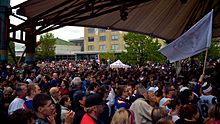
Canada Day at the Forks is an all day event, with activities happening throughout the Forks grounds, and culminating in a fireworks show.[102]
Salsa Sundays
Salsa Sundays is a weekly event run at the Forks under the canopy during the summer, featuring free dance instruction and demonstrations set to live Latin music and DJ mixes.[103]
The Winnipeg International Children's Festival is a children's festival held annually at The Forks National Historic Park. Founded in 1983, it was held at Assiniboine Park, then at Kildonan Park from 1984 through 1989, and eventually moving to its present location in 1990. The festival is made up of over 30 acts, held over four days, totalling about 120 performances.[104][105]
Future projects
This section needs to be updated. Please help update this article to reflect recent events or newly available information.(June 2021)
The following projects are part of the ten-year revitalization plan for The Forks.[106]
Winnipeg is the capital and largest city of the province of Manitoba in Canada. It is centred on the confluence of the Red and Assiniboine rivers, near the longitudinal centre of North America. As of 2021, Winnipeg had a city population of 749,607 and a metropolitan population of 834,678, making it Canada's sixth-largest city and eighth-largest metropolitan area.
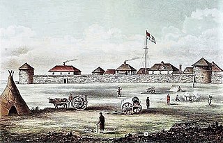
Fort Garry, also known as Upper Fort Garry, was a Hudson's Bay Company trading post located at the confluence of the Red and Assiniboine rivers in or near the area now known as The Forks in what is now central Winnipeg, Manitoba.
The Red River, also called the Red River of the North to differentiate it from the Red River in the south of the continent, is a river in the north-central United States and central Canada. Originating at the confluence of the Bois de Sioux and Otter Tail rivers between the U.S. states of Minnesota and North Dakota, it flows northward through the Red River Valley, forming most of the border of Minnesota and North Dakota and continuing into Manitoba. It empties into Lake Winnipeg, whose waters join the Nelson River and ultimately flow into Hudson Bay.
The Assiniboine River is a 1,070-kilometre (660 mi) river that runs through the prairies of Western Canada in Saskatchewan and Manitoba. It is a tributary of the Red River. The Assiniboine is a typical meandering river with a single main channel embanked within a flat, shallow valley in some places and a steep valley in others. Its main tributaries are the Qu'Appelle, Souris, and Whitesand Rivers. For early history and exploration see Assiniboine River fur trade.
St-Boniface is a city ward and neighbourhood in Winnipeg. Along with being the centre of the Franco-Manitoban community, it ranks as the largest francophone community in Western Canada.
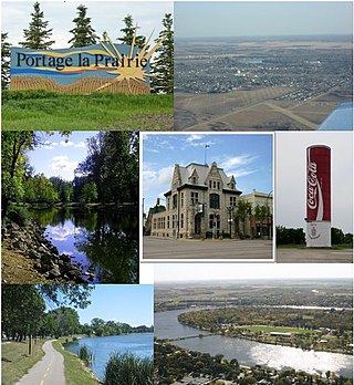
Portage la Prairie is a small city in the Central Plains Region of Manitoba, Canada. As of 2016, the population was 13,304 and the land area of the city was 24.68 square kilometres (9.53 sq mi).
Charleswood is a residential community and neighbourhood in Winnipeg, Manitoba, Canada. It is located in the South-West of the city and is bordered by the neighbourhoods Tuxedo to the East, Fort Whyte to the South, and the Rural Municipality of Headingley on the West. Its boundaries are Roblin and the Assiniboine River to the north, Shaftesbury Boulevard on the East, Wilkes Avenue to the South and the Perimeter Highway to the West.
The Provencher Bridge is a set of paired bridges — a four-lane vehicular bridge and a suspended pedestrian bridge — across the Red River in Winnipeg, Manitoba.
Assiniboine Park is a park in Winnipeg, Manitoba, Canada, located along the Assiniboine River.
Fort La Reine was built in 1738 and is one of the forts of the western expansion directed by Pierre Gaultier de Varennes et de La Vérendrye, first military commander in the west of what is now known as Canada. Located on the Assiniboine River where present day Portage la Prairie, Manitoba, stands, the fort served as a fur trading post. It was also the base of operations for much exploration north and west. From Fort La Reine, explorers made their way to Lake Manitoba and Lake Winnipegosis, Lake Winnipeg and the Saskatchewan River.
Downtown Winnipeg is an area of Winnipeg located near the confluence of the Red and Assiniboine rivers. It is the oldest urban area in Winnipeg, and is home to the city's commercial core, city hall, the seat of Manitoba's provincial government, and a number of major attractions and institutions.
Esplanade Riel is a pedestrian bridge located in Winnipeg, Manitoba. It was named in honour of Louis Riel.
Winnipeg lies at the bottom of the Red River Valley, a low-lying flood plain with an extremely flat topography. This valley was formed by the ancient glacial Lake Agassiz which has rich deposits of black soil. Winnipeg is on the eastern edge of the Canadian Prairies in Western Canada; it is known as the 'Gateway to the West'. It is relatively close to many large Canadian Shield lakes and parks, as well as Lake Winnipeg. Winnipeg is bordered by tallgrass prairie to the west and south and the aspen parkland to the northeast.
Route 52 is a major north-south arterial route in Winnipeg, Manitoba, Canada. It comprises all of Main Street, Queen Elizabeth Way, and St. Mary's Road.
The history of Winnipeg comprises its initial population of Aboriginal peoples through its settlement by Europeans to the present day. The first forts were built on the future site of Winnipeg in the 1700s, followed by the Selkirk Settlement in 1812. Winnipeg was incorporated as a city in 1873 and experienced dramatic growth in the late 19th and early 20th centuries. Following the end of World War I, the city's importance as a commercial centre in Western Canada began to wane. Winnipeg and its suburbs experienced significant population growth after 1945, and the current City of Winnipeg was created by the unicity amalgamation in 1972.
This is a timeline of the history of Winnipeg.
Riel House is a National Historic Site commemorating the life of the Métis politician and activist Louis Riel, and also the daily life of Métis families in the Red River Settlement. The house is situated in the historic St. Vital parish of Winnipeg, in Manitoba, Canada. From 1865, the residence belonged to Riel's mother, Julie Riel (Lagimodière), and housed his brothers and their families. Louis Riel lived along with them from his return to Red River in 1868, through the Red River Resistance, until his exile in 1870. It is also where his body lay in state for two days in December 1885, after his sentencing and execution for murder and treason, before being buried in St. Boniface. The house remained within the possession of Riel descendants until 1968, when it was acquired by the Winnipeg Historical Society.
Broadway is a street in the city of Winnipeg, Manitoba, Canada. It is one of the city's oldest and most historic routes and forms the Trans-Canada Highway route through the city's downtown.
Most of the following timelines for Manitoba's history is taken from either the Manitoba Historical Society, or from the Heritage Manitoba and the Gimli Municipal Heritage Advisory Committee, as adapted from a three-volume history of Manitoba published in 1993 titled Manitoba: 125.
1 2 "A Walk Through the Site". The Forks National Historic Site of Canada. Parks Canada. 22 June 2009. Archived from the original on 18 June 2015. Retrieved 5 September 2012.
↑ W. F. Rennie; L. H. Thorleifson; J. T. Teller (3 August 1987). "Holocene evolution of the Assiniboine River paleochannels and Portage in Prairie alluvial fan". Canadian Journal of Earth Sciences. 26 (9) (published September 1989): 1834–1841. doi:10.1139/e89-156.
This page is based on this Wikipedia article Text is available under the CC BY-SA 4.0 license; additional terms may apply. Images, videos and audio are available under their respective licenses.