Thorndale | |
---|---|
Coordinates: 39°59′47″N75°45′06″W / 39.99639°N 75.75167°W | |
Country | United States |
State | Pennsylvania |
County | Chester |
Township | Caln |
Area | |
• Total | 1.8 sq mi (5 km2) |
• Land | 1.8 sq mi (5 km2) |
• Water | 0.0 sq mi (0 km2) |
Elevation | 344 ft (105 m) |
Population (2010) | |
• Total | 3,407 |
• Density | 1,900/sq mi (730/km2) |
Time zone | UTC-5 (EST) |
• Summer (DST) | UTC-4 (EDT) |
ZIP code | 19372 |
Area code(s) | 610 and 484 |
Thorndale is a census-designated place in Caln Township, Chester County, Pennsylvania, United States. The population was 3,407 at the 2010 census.
Thorndale is the commercial and administrative center of Caln Township. The community's main street is U.S. Route 30 Business. Many of Thorndale's old houses fell into disrepair from the late 1990s to present and have been torn down and replaced with new businesses.
Thorndale is historically notable for containing a summer house of U.S. President James Buchanan, which still stands and has been incorporated into a golf course and turned into a restaurant. The community contains the Thorndale Fire Station and Caln Elementary School, part of the Coatesville Area School District. Thorndale sits along SEPTA's Paoli/Thorndale Line and is currently the last station stop on that line. It is also served by the SEPTA Route 135 bus.
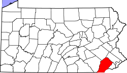
Thorndale is located at 39°59′47″N75°45′6″W / 39.99639°N 75.75167°W (39.996456, -75.751606). [1]
According to the U.S. Census Bureau, Thorndale has a total area of 1.8 square miles (4.7 km2), of which 0.55% is water. It is part of Caln Township, with students attending school in either the Coatesville Area School District or the Downingtown Area School District.
As of the 2000 census, [2] there were 3,561 people, 1,347 households, and 952 families residing in the CDP. The population density was 1,953.2 inhabitants per square mile (754.1/km2). There were 1,418 housing units at an average density of 777.8 per square mile (300.3/km2). The racial makeup of the CDP was 82.65% White, 10.98% African American, 0.22% Native American, 2.33% Asian, 0.11% Pacific Islander, 2.13% from other races, and 1.57% from two or more races. Hispanic or Latino of any race were 4.32% of the population.
There were 1,347 households, out of which 36.8% had children under the age of 18 living with them, 57.2% were married couples living together, 9.3% had a female householder with no husband present, and 29.3% were non-families. 22.3% of all households were made up of individuals, and 5.4% had someone living alone who was 65 years of age or older. The average household size was 2.63 and the average family size was 3.12.
The population in Thorndale was spread out, with 26.1% under the age of 18, 7.9% from 18 to 24, 36.1% from 25 to 44, 21.1% from 45 to 64, and 8.7% who were 65 years of age or older. The median age was 35 years. For every 100 females, there were 94.8 males. For every 100 females age 18 and over, there were 95.2 males.
The median income for a household in the CDP was $61,830, and the median income for a family was $70,781. Males had a median income of $45,573 versus $35,096 for females. The per capita income for the CDP was $25,376. About 4.4% of families and 6.4% of the population were below the poverty line, including 9.9% of those under age 18 and 14.5% of those age 65 or over.
The school district is Coatesville Area School District. [3]
Pinardville is a census-designated place (CDP) in the town of Goffstown, Hillsborough County, New Hampshire, United States. It is a suburban neighborhood adjacent to the city of Manchester. The population was 5,034 at the 2020 census. Pinardville has existed since 1906.
Richboro is a census-designated place (CDP) in Northampton Township, Bucks County, Pennsylvania, United States. The population was 6,378 during the 2020 census.
Atglen is a borough in Chester County, Pennsylvania, United States. According to the 2020 census, its population is 1,311.
Caln Township is a township in Chester County, Pennsylvania, United States. The population was 14,432 at the 2020 census. The township was founded by settlers from Calne, Wiltshire in England in 1714; the relationship between Calne and Wiltshire continues in the present since the two are sister cities. Caln is a township of the First Class, and the governing body is a Board of Commissioners. The township also owns Ingleside Golf Club and over 200 acres (0.81 km2) of green space and parks.
Chesterbrook is a census-designated place (CDP) in Chester County, Pennsylvania, United States. It is located within the Philadelphia metropolitan area and just south of Valley Forge National Historical Park. The population was 4,589 at the 2010 census.
Coatesville is a city in Chester County, Pennsylvania, United States. The population was 13,350 at the 2020 census. Coatesville is approximately 39 miles west of Philadelphia. It developed along the Philadelphia and Lancaster Turnpike beginning in the late 18th century. It spans U.S. Route 30, the "Main Line" highway that runs west of Philadelphia.
East Caln Township is a township in Chester County, Pennsylvania, United States. The population was 5,387 at the 2020 census. The township wraps around the eastern half of Downingtown and is mostly indistinguishable from it. East Caln Township is very developed, containing several shopping centers, including the regionally important Brandywine Square Center, several recently constructed housing developments varying from condominiums to large single family homes, and some industry in the southern fringe of the township.
Exton is a census-designated place (CDP) in West Whiteland Township in Chester County, Pennsylvania, United States. Its population was 5,622 at the 2020 census. The Exton Square Mall and Main Street at Exton are both located within Exton along with several other shopping centers, making Exton the major shopping district in Chester County.
Paoli is a census-designated place (CDP) in Chester County near Philadelphia, Pennsylvania, United States. It is situated in portions of two townships: Tredyffrin and Willistown. At the 2020 census, it had a total population of 6,002.
West Brandywine Township is a township that is located in Chester County, Pennsylvania, United States. The population was 7,394 at the time of the 2010 census.
Folsom is a census-designated place (CDP) in Delaware County, Pennsylvania, United States. It is part of Ridley Township. The population was 8,323 at the 2010 census.
Linwood is a census-designated place (CDP) in Delaware County, Pennsylvania, United States. The population was 3,281 at the 2010 census.
Village Green-Green Ridge is a census-designated place (CDP) in Aston Township, Delaware County, Pennsylvania, United States. The population was 7,822 at the 2010 census, down from 8,279 at the 2000 census.
Montgomeryville is a census-designated place (CDP) in Montgomery Township, Montgomery County, Pennsylvania, United States. The population was 12,624 at the 2010 census. According to a 2010 Forbes magazine/Yahoo.com survey, Montgomeryville ranks 5th in America's top 10 affordable suburbs. It is part of the North Penn Valley region that is centered on the borough of Lansdale.
Oreland is a United States census-designated place (CDP) in Springfield and Upper Dublin townships, just outside the Chestnut Hill and Mount Airy areas of Philadelphia, Pennsylvania, United States. Oreland has a ZIP code of 19075, and the population was 5,678 at the 2010 census.
Spring House is a census-designated place (CDP) in Lower Gwynedd Township, Montgomery County, Pennsylvania, United States. The population was 3,978 at the 2020 census.
Wyncote is a census-designated place (CDP) in Cheltenham Township, Montgomery County, Pennsylvania, United States. It borders the northwestern and northeastern section of Philadelphia. Wyncote is located 11 miles from Center City Philadelphia at the southeasternmost tip of Montgomery County. The Jenkintown-Wyncote SEPTA station is the fifth busiest regional rail station in the SEPTA system.
K-Bar Ranch is a census-designated place (CDP) in Jim Wells County, Texas, United States. The population was 375 at the 2020 census.
Caln is a census-designated place (CDP) in Caln Township, Chester County, Pennsylvania, United States. The population was 1,519 at the 2010 census. It is located east of the city of Coatesville and lies west of Philadelphia.
Norway is a census-designated place (CDP) in the town of Norway in Oxford County, Maine, United States. The population was 2,623 at the 2000 census.