Trout Lake Township, Itasca County, Minnesota

Last updated
Trout Lake Township, Minnesota
USA Minnesota location map.svg
Red pog.svg
Trout Lake Township, Minnesota
Location within the state of Minnesota
Usa edcp location map.svg
Red pog.svg
Trout Lake Township, Minnesota
Trout Lake Township, Minnesota (the United States)
Coordinates: 47°14′0″N93°22′27″W / 47.23333°N 93.37417°W / 47.23333; -93.37417 Coordinates: 47°14′0″N93°22′27″W / 47.23333°N 93.37417°W / 47.23333; -93.37417
Country United States
State Minnesota
County Itasca
Area
  Total34.7 sq mi (89.8 km2)
  Land30.5 sq mi (79.1 km2)
  Water4.1 sq mi (10.7 km2)
Elevation
1,289 ft (393 m)
Population
 (2010)
  Total1,087
  Density31/sq mi (12/km2)
Time zone UTC-6 (Central (CST))
  Summer (DST) UTC-5 (CDT)
FIPS code 27-65596 [1]
GNIS feature ID0665811 [2]

Trout Lake Township is located in north central Minnesota in Itasca County, United States. It is bordered by the City of Coleraine to the west and north, City of Bovey on the north, an unorganized township on the east, and Blackberry Township to the south. Town government was adopted on March 6, 1894. The population was 1,056 at the 2020 census. [3]

Contents

Geography

In 1870, Trout Lake Township, or 55 N Range 24 W of the 4th PM (principal meridian), was surveyed as part of the Public Land Survey System. According to the United States Census Bureau, the township has a total area of 34.7 square miles (89.8 km2), of which 30.5 square miles (79.1 km2) is land and 4.1 square miles (10.7 km2), or 11.91%, is water. The Swan River and several lakes are within the township of which Trout Lake is the largest at 1862.08 acres with a maximum depth of 135 feet. [4] The land sits in the Laurentian Mixed Forest Province, defined by a mixture of deciduous and coniferous forests. [5] It is on top of the western portion of the Mesabi Iron Range.

Natural resources

Timber

Logging in Trout Lake Township corresponds with the exhibits and re-enactments at the Minnesota Forest History Center, a site just 10 miles distant. The 1890s to 1910 was the "golden era" of lumbering in Minnesota. [6] According to local interviews archived at the Iron Range Research Center, there were logging camps in the township. Settlers worked to provide railroad ties. [7]

Today, private landowners are encouraged to manage the forest through organizations such as the Minnesota Forestry Association, [8] and to enroll in Woodland Stewardship Plans. [9] Itasca County, certified by the Forest Stewardship Council, [5] manages tax forfeited public properties in Trout Lake Township for timber; cover type aspen-birch. [10]

Iron ore

Iron ore was processed into taconite at the Trout Lake Washing and Concentrator Plant, 1907-1970. The plant, and the adjacent Trout Lake, provided it with a convenient location to deposit its tailings, which were pumped into the lake for nearly three decades. [11]

The Oliver Iron Mining Company's concentrator plant, its power station on the lake, and the workers' Bugaloosa location, are now gone. [7] The history continues to qualify Trout Lake Township for Taconite Assistance and Tax Relief, [12] and for benefits from the Iron Range Resources and Rehabilitation Board.

Water

The natural water system is in the Prairie-Willow Subbasin, of the Mississippi Headwaters Basin, within the Upper Mississippi Region. [13] It is in Supervisor District 4 of the Itasca County Soil and Water Conservation District. [14] Besides several creeks and Swan River, there are seven protected lakes. Each has a distinguishing number in the state’s identification system. [15] The lakes are:

Bass, Clearwater, and Round lakes are classified by Itasca County as "phosphorus sensitive lakes". [16] Blackberry and Mud lakes are on the state's inventory for wild rice. [17] Trout lake has not had trout species since the 1940s. It is classified as a Cisco Refuge Lake because it has deep, cold water. [18]

The state maintains a boat landing on the southeast end of Trout Lake. [19] It adjoins a campground that was previously a public park. Historically, the park was for company picnics of the Oliver Mining Company. It transferred to Greenway Lions Club and developed into Kom-On-In Beach and Recreation Area with the aid of Iron Range Resources and Rehabilitation Board. [20] After approximately half a century, the property was sold and is now Trout Lake RV Park and Campground. [21]

Wildlife

Fishing, hunting and trapping are regulated by federal and state laws, managed by the Minnesota Department of Natural Resources (MN DNR), and enforced by MN DNR conservation officers and Itasca County Sheriff's Department.

Alder Pond Ruffed Grouse Management Area and recreation trail system are on 190 acres located between town sections 29 and 32. It is managed by Itasca County, with Grand Rapids Ruffed Grouse Society and MN DNR as partners. The public trails are used for hiking, horseback riding, and hunting, plus 6.03 miles are groomed by Northern Lights Nordic Ski Club for cross-country skiing. [22] [23]

Trout Lake Eagle Wildlife Management Area preserves three eagle nests and several potential white pine nesting trees. The area is one of the longest known bald eagle nesting sites in Minnesota. [24] Two parcels of undeveloped land (located on opposite sides of Trout Lake) were purchased by a joint effort of MN DNR Nongame Wildlife Program, [25] Reinvest In Minnesota (RIM) [26] and the Nature Conservancy. [10]

Community

Demographics

The Minnesota State Demographic Center [27] estimated the 2019 population of Trout Lake Township at 1093 people in 455 households. The 2020 US Census found the population at 1056 in 491 households. 5.4% were below the poverty level in 2020 compared to 11.5% the year before the US 2010 census. The residents of Trout Lake Township are 98.6% white. When the United States 2010 census was taken, none had been born outside of the country, and 80% had been born in Minnesota. 20.6% of the people within the marrying age (ages 15 and over) had never been married. 25.2% of residents ages 25 and over had some college or an associate's degree. [3]

Town government

The settlers in the geographic township of Trout Lake, on March 6, 1894, organized themselves into a political township. The township became a public corporation, according to Minn. Stat. § 365.02, [28] with governing authority granted by the state legislature. [29] The first supervisors were N. Washburn, C.S. Brock, and August Keihta; clerk F.H. Webster; and treasurer, Robert Smith. Their first priority was building roads. [30]

With town government, residents decide at the annual town meeting, held on the second Tuesday of March, what the town levy will be, and to approve actions to be taken by the town board. The residents may also call special town meetings to address concerns. [31] The Trout Lake town board meets at least monthly to oversee over 20 miles of township roads, two cemeteries, and a community center on ten acres with a playground, pavilion, and ball field. The town supervisors also represent the community on county committees, and joint powers associations. Trout Lake is also a voting precinct and administers a polling place at the Trout Lake Community Center. [30]

Basic rural services

9-1-1 emergency calls are directed to the appropriate agency for help. Trout Lake Township is patrolled by Itasca County Sheriff's Department. The town contracts with both Trout Lake Fire Department and Grand Rapids Fire Department. The majority of rural mail delivery is provided by the US Post Office in Bovey, and a southern portion, by the US Post Office in Grand Rapids; hence mailing addresses are zip codes 55709 or 55744 respectively. The community is connected by a network of county and township roads. The main thoroughfares are Trout Lake Road (#21), County Road 10, and County Road 71.

The rural community of Trout Lake supports the economic and social infrastructure of its surrounding cities. There are not any active schoolhouses, churches, stores, or industries in the township. The township is within these service areas for amenities:

Related Research Articles

St. Louis County, Minnesota County in Minnesota, United States

St. Louis County is a county located in the Arrowhead Region of the U.S. state of Minnesota. As of the 2020 census, the population was 200,231. Its county seat is Duluth. It is the largest county in Minnesota by land area, and the largest in the United States by total area east of the Mississippi River, ahead of Aroostook County, Maine.

Lake County, Minnesota County in Minnesota, United States

Lake County is a county in the U.S. state of Minnesota. As of the 2020 census, the population was 10,905. Its county seat is Two Harbors.

Itasca County, Minnesota County in Minnesota, United States

Itasca County is located in the State of Minnesota. As of the 2020 census, the population was 45,014. Its county seat is Grand Rapids. The county is named after Lake Itasca, which is in turn a shortened version of the Latin words veritas caput, meaning 'truth' and 'head', a reference to the source of the Mississippi River. Portions of the Bois Forte and Leech Lake Indian reservations are in the county.

Crow Wing County, Minnesota County in Minnesota, United States

Crow Wing County is a county in the East Central part of the U.S. state of Minnesota. As of the 2020 census, the population was 66,123. Its county seat is Brainerd. The county was formed in 1857, and was organized in 1870.

Clearwater County, Minnesota County in Minnesota, United States

Clearwater County is a county in the northwestern part of the U.S. state of Minnesota. As of the 2020 census, the population was 8,524. Its county seat is Bagley.

Bovey, Minnesota City in Minnesota, United States

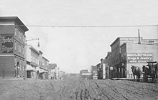
Bovey is a city in Itasca County, Minnesota, United States. It is part of Minnesota's Iron Range. The population was 804 at the 2010 census.

Grand Rapids, Minnesota City in Minnesota, United States

Grand Rapids is a city in and the county seat of Itasca County, Minnesota, United States. The population was 11,126 at the 2020 census. The surrounding bedroom communities of Cohasset, Coleraine, LaPrairie, Bovey, Taconite, Marble, and Calumet increase the urban area population to an estimated 18,908 people (2021). The city is named for the 3.5-mile (5.6 km) long local rapids in the Mississippi River, which was the uppermost limit of practical steamboat travel during the late 19th century. Today the rapids are hidden below the dam of the Blandin Paper Mill.

Iron Range Iron-ore mining districts around Lake Superior in the United States and Canada

The term Iron Range refers collectively or individually to a number of elongated iron-ore mining districts around Lake Superior in the United States and Canada. Despite the word "range", the iron ranges are not mountain chains, but outcrops of Precambrian sedimentary formations containing high percentages of iron. These cherty iron ore deposits are Precambrian in age for the Vermilion Range and middle Precambrian in age for the Mesabi and Cuyuna ranges, all in Minnesota. The Gogebic Range in Wisconsin and the Marquette Iron Range and Menominee Range in Michigan have similar characteristics and are of similar age. Natural ores and concentrates were produced from 1848 until the mid 1950s, when taconites and jaspers were concentrated and pelletized, and started to become the major source of iron production.

Leech Lake Body of water

Leech Lake is a lake located in north central Minnesota, United States. It is southeast of Bemidji, located mainly within the Leech Lake Indian Reservation, and completely within the Chippewa National Forest. It is used as a reservoir. The lake is the third largest in Minnesota, covering 102,947.83 acres (416.6151 km2) with 195 miles (314 km) of shoreline and has a maximum depth of 156 feet (48 m).

Lake Vermilion Body of water

Lake Vermilion is a shallow freshwater lake in northeastern Minnesota, United States. The Ojibwe originally called the lake Nee-Man-Nee, which means “the evening sun tinting the water a reddish color”. French fur traders translated this to the Latin word Vermilion, which is a red pigment. Lake Vermilion is located between the towns of Tower on the east and Cook on the west, in the heart of Minnesota's Arrowhead Region at Vermilion Iron Range. The area was mined from the late 19th century until the 1960s, and the Soudan Mine operated just south of the lake.

Arrowhead Region

The Arrowhead Region is located in the northeastern part of the U.S. state of Minnesota, so called because of its pointed shape. The predominantly rural region encompasses 10,635.26 square miles (27,545.2 km2) of land area and includes Carlton, Cook, Lake and Saint Louis counties. Its population at the 2000 census was 248,425 residents. The region is loosely defined, and Aitkin, Itasca, and Koochiching counties are sometimes considered as part of the region, increasing the land area to 18,221.97 square miles (47,194.7 km2) and the population to 322,073 residents. Primary industries in the region include tourism and iron mining.

Bear Head Lake State Park State park of Minnesota, United States

Bear Head Lake State Park is a state park of Minnesota, United States, providing ready access to outdoor recreation in the Boundary Waters region. It boasts scenery similar to the nearby Boundary Waters Canoe Area Wilderness, with the added conveniences of road access, modern facilities, and motorboating. The most popular visitor activities are boating, fishing, swimming, and hiking. The park entirely surrounds 670-acre (270 ha) Bear Head Lake and three other fishing lakes. It was established in 1961 in Saint Louis County near Ely, Minnesota. The park also contains the woodlands surrounding the lakes, which gives an entire total of about 5,540 acres. The park also shares a large border with Bear Island State Forest.

Minnesota Department of Natural Resources State government agency in Minnesota, United States

The Minnesota Department of Natural Resources, or Minnesota DNR, is the agency of the U.S. state of Minnesota charged with conserving and managing the state's natural resources. The agency maintains areas such as state parks, state forests, recreational trails, and recreation areas as well as managing minerals, wildlife, and forestry throughout the state. The agency is divided into six divisions - Ecological & Water Resources, Enforcement, Fish & Wildlife, Forestry, Lands & Minerals, and Parks & Trails.

Bad Medicine Lake is a spring-fed lake located in Forest Township in Becker County, Minnesota. It got its name from the fact that early Native Americans in the area thought that a lake with neither inlet nor outlet was a place of bad omen and would not hunt or fish near the lake.

Geography of Minnesota Overview of the geography of Minnesota

The U.S. State of Minnesota is the northernmost state outside Alaska; its isolated Northwest Angle in Lake of the Woods is the only part of the 48 contiguous states lying north of the 49th parallel north. Minnesota is in the U.S. region known as the Upper Midwest in interior North America. The state shares a Lake Superior water border with Michigan and Wisconsin on the northeast; the remainder of the eastern border is with Wisconsin. Iowa is to the south, North Dakota and South Dakota are to the west, and the Canadian provinces of Ontario and Manitoba are to the north. With 87,014 square miles (225,370 km2), or approximately 2.26% of the United States, Minnesota is the 12th largest state.

The Little Isabella River is a 33.17 mi (53.38 km) stream in Superior National Forest, a United States National Forest in the U.S. state of Minnesota. The stream runs through Stony River Township, which is part of Lake County. The Little Isabella River Campground, which is operated by the United States Forest Service, is about 5 miles (8.0 km) north of Isabella, Minnesota, an unincorporated community. The Minnesota Department of Natural Resources has designated it as a trout stream and it is populated with Brook trout.

The Taconite State Trail extends 165 miles from Grand Rapids, Minnesota to Ely, Minnesota and intersects the Arrowhead State Trail west of Lake Vermilion. On the Grand Rapids end, the trail is paved for the first 6 miles for in-line skating and biking. The rest of the trail is natural surface used primarily in the winter months for snowmobiling. In the summer, several areas contain standing water, but some areas are suitable for horseback riding, hiking, and mountain biking

The George Washington State Forest is a state forest located in Itasca, Koochiching, and Saint Louis counties, Minnesota. The forest was established and named after George Washington in 1931, the first President of the United States, to commemorate the bicentennial of his birth. The forest borders the Chippewa National Forest and completely environs the Scenic State Park to the west, and borders the Sturgeon River State Forest and McCarthy Beach State Park to the east. The Taconite State Trail passes through the forest.

Crescent Lake (Minnesota) Body of water

Crescent Lake is a lake located in Tofte Township and Lutsen Township, Cook County, Minnesota.

Martin is an unincorporated community in Balsam Township, Itasca County, Minnesota, United States.

References

  1. "U.S. Census website". United States Census Bureau . Retrieved 2008-01-31.
  2. "US Board on Geographic Names". United States Geological Survey. 2007-10-25. Retrieved 2008-01-31.
  3. 1 2 "Explore Census Data".
  4. "Trout (31021600) | LakeFinder".
  5. 1 2 Itasca County Forest Management Plan 2019. p. 6 https://www.co.itasca.mn.us/DocumentCenter/View/5536/2019-Forest-Management-Plan
  6. "Timeline".
  7. 1 2 "Iron Range Research Center". Iron Range Research Center. Retrieved 2022-07-20.
  8. "Minnesota Forestry Association". Minnesota Forestry Association. Retrieved 2022-07-20.
  9. "Itasca County SWCD Forestry Program".
  10. 1 2 "Aspen for Timber in Alder Pond (Itasca County)". 25 June 2018.
  11. "The Trout Lake Concentrator - Coleraine, MN".
  12. "Taconite Assistance and Tax Relief Areas | Minnesota Department of Revenue".
  13. USDA Natural Resources Conservation Services Rapid Watershed Assessment Prairie-Willow (MN) HUC: 07010103. 20 pgs. https://www.nrcs.usda.gov/Internet/FSE_DOCUMENTS/nrcs142p2_021558.pdf
  14. "About Itasca SWCD".
  15. "LakeFinder". Minnesota Department of Natural Resources. Retrieved 2022-07-20.
  16. "Lake Classficiations | Itasca County, MN".
  17. MN Department of Natural Resources excerpt of the 2008 report "Natural Wild Rice" submitted to the Legislature. .https://files.dnr.state.mn.us/fish_wildlife/wildlife/wildrice/statewide-inventory-wild-rice-waters.pdf
  18. RMB Environmental Laboratories, Inc. 2015 Trout Lake 31-0216-00 Itasca County. https://www.rmbel.info/wp-content/uploads/2015/12/Trout_31-0216-00-1.pdf pgs. 22, 24
  19. "Water Access Sites: Trout (31021600) | LakeFinder".
  20. November 24, 1998 | Duluth News Tribune (MN) Author: Lee Bloomquist/News-Tribune staff writer | Page: 02B | Section: Local & State News
  21. "Bovey MN Campground | Trout Lake RV Park and Campground". 6 June 2016.
  22. "Northern Lights Nordic Ski Club". northernlightsnordic.org.
  23. "Archived copy". Archived from the original on 2021-04-27. Retrieved 2021-04-27.{{cite web}}: CS1 maint: archived copy as title (link)
  24. "Habitat preservation projects".
  25. "Nongame Wildlife Program".
  26. "Reinvest in Minnesota Overview | MN Board of Water, Soil Resources". bwsr.state.mn.us.
  27. "PopFinder for Cities & Townships".
  28. Minn. Stat. § 365.02 https://www.revisor.mn.gov/statutes/cite/365.02
  29. "Archived copy" (PDF). Archived from the original (PDF) on 2020-09-28. Retrieved 2021-04-28.{{cite web}}: CS1 maint: archived copy as title (link)
  30. 1 2 Town of Trout Lake minutes 24951 County Road 10, Bovey, MN 55709
  31. "Archived copy" (PDF). Archived from the original (PDF) on 2020-09-28. Retrieved 2021-04-28.{{cite web}}: CS1 maint: archived copy as title (link)
  32. "Home | Lake Country Power". www.lakecountrypower.coop. Retrieved 2022-07-20.
  33. "Paul Bunyan Communications". Paul Bunyan Communications. Retrieved 2022-07-20.
  34. "Itasca County". Arrowhead Transit.
  35. "Home - Greenway Public School District".
  36. "Independent School District 318 / Homepage". www.isd318.org. Retrieved 2022-07-20.
  37. "IASC Community Education". www.getlearning.org. Retrieved 2022-07-20.
  38. "Arrowhead Library System | Home | Mountain Iron, MN". Arrowhead Library System.
  39. "Public Health Division | Itasca County, MN". www.co.itasca.mn.us.
  40. Elder Circle. "Home". www.eldercircle.org. Retrieved 2022-07-20.
  41. "Mission".