Related Research Articles

Pasadena is a city in the U.S. state of Texas, within the Houston–The Woodlands–Sugar Land metropolitan area. As of the 2020 U.S. Census, the city's population is 151,950, making it the twentieth most populous city in the state of Texas, as well as the second-largest city in Harris County. The area was founded in 1893 by John H. Burnett of Galveston, who named the area after Pasadena, California, because of the perceived lush vegetation.
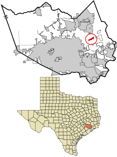
Sheldon is an unincorporated community and a census-designated place (CDP) in northeastern Harris County, Texas, United States located completely inside the extraterritorial jurisdiction of the City of Houston. The Sheldon area is located along Beltway 8 and US Highway 90 approximately twelve miles (20 km) northeast of Downtown Houston.

The Trinity River is a 710-mile (1,140 km) long river in Texas, and is the longest river with a watershed entirely within the U.S. state of Texas. It rises in extreme northern Texas, a few miles south of the Red River. The headwaters are separated by the high bluffs on the southern side of the Red River.
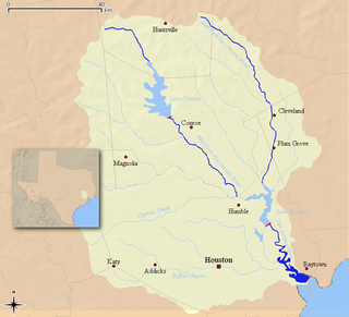
The San Jacinto River flows through southeast Texas. It is named after Saint Hyacinth. In the past, it was home to the Karankawa and Akokisa tribes.

The Memorial area of Houston, Texas is located west of Downtown, northwest of Uptown, and south of Spring Branch. The Memorial Super Neighborhood, as defined by the City of Houston, is bounded by Buffalo Bayou to the south, Barker Reservoir to the west, the Katy Freeway to the north, and the Memorial Villages, a contiguous group of independent municipalities, to the east.

Buffalo Bayou is a slow moving body of water which flows through Houston in Harris County, Texas. Formed 18,000 years ago, it has its source in the prairie surrounding Katy, Fort Bend County, and flows approximately 53 miles (85 km) east through the Houston Ship Channel into Galveston Bay and the Gulf of Mexico. In addition to drainage water impounded and released by the Addicks and Barker reservoirs, the bayou is fed by natural springs, surface runoff, and several significant tributary bayous, including White Oak Bayou, Greens Bayou, and Brays Bayou. Additionally, Buffalo Bayou is considered a tidal river downstream of a point 440 yards (400 m) west of the Shepherd Drive bridge in west-central Houston.
Timeline of historical events of Houston, Texas, United States:

The Houston Ship Channel, in Houston, Texas, is part of the Port of Houston, one of the busiest seaports in the world. The channel is the conduit for ocean-going vessels between Houston-area terminals and the Gulf of Mexico, and it serves an increasing volume of inland barge traffic.
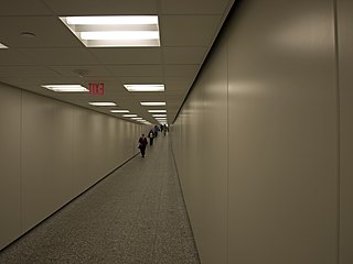
The Houston tunnel system is a network of subterranean, climate-controlled, pedestrian walkways that links 95 full city blocks 20 feet (6 m) below Houston's downtown streets. It is approximately six miles (9.7 km) long. There are similar systems in Chicago, Dallas, Oklahoma City, Montreal, and Toronto. Architectural historian Stephen Fox has stated that the idea for the tunnel system came when the Bank of the Southwest Building was "linked by tunnel to the 1010 Garage and the Mellie Esperson Building" in 1961.

Allen's Landing is the officially recognized birthplace of the city of Houston, Texas, United States, the largest city in Texas and the fourth largest in the United States. Located in Downtown Houston between the Main Street and Fannin Street viaducts, the landing encompasses the southern bank of Buffalo Bayou, the city's principal river, at its confluence with White Oak Bayou, a major tributary. Allen's Landing is located south of the University of Houston–Downtown Commerce Street Building.
North Shore is a community in east side of Harris County, Texas with a small portion inside the city of Houston, Texas. The area includes subdivisions such as Songwood, Holiday Forest, Wood Bayou, Cimarron, Home Owned Estates, Woodland Acres, Hidden Forest, Pine Trails, Woodforest, Woodforest North, New Forest, and New Forest West, as well as newer neighborhoods near Highway 90 and Beltway 8 North Sam Houston Parkway.

Houston, the most populous city in the Southern United States, is located along the upper Texas Gulf Coast, approximately 50 miles (80 km) northwest of the Gulf of Mexico at Galveston. The city, which is the ninth-largest in the United States by area, covers 601.7 square miles (1,558 km2), of which 579.4 square miles (1,501 km2), or 96.3%, is land and 22.3 square miles (58 km2), or 3.7%, is water.
White Oak Bayou is a slow-moving river in Houston, Texas. A major tributary of the city's principal waterway, Buffalo Bayou, White Oak originates near the intersection of Texas State Highway 6 and U.S. Highway 290 and meanders southeast for 25 miles (40 km) until it joins Buffalo Bayou in Downtown. The river serves as a greenway which connects Downtown to the Houston Heights, Oak Forest, Garden Oaks, and Inwood Forest.
Carpenters Bayou rises at the south end of Sheldon Reservoir in southeastern Harris County, Texas, USA, and runs southeast for about twelve miles until it joins Buffalo Bayou at the San Jacinto Battleground State Historic Site.

Idylwood is a historic neighborhood in the southeastern part of the I-610 loop in Houston, Texas. Idylwood, as of 2021, is the most expensive neighborhood in the East End. As of that year its houses were priced between $295,000 and $679,900. It currently has approximately 340 homes. Bill England, a redeveloper in the East End area, stated in 2004 that Idylwood appealed to buyers who are priced out of houses located in the cities of Bellaire and West University Place.
Cedar Bayou is an area in east central Harris County, Texas, United States.

Barker Reservoir is a flood control structure in Houston, Texas which prevents downstream flooding of Buffalo Bayou, the city's principal river. The reservoir operates in conjunction with Addicks Reservoir to the northeast, which impounds Mayde and Bear Creeks, two tributaries of the Buffalo. Both reservoirs were authorized under the Rivers and Harbors Act of June 20, 1938, which were modified by the Flood Control Acts of August 11, 1938; September 3, 1954; and October 27, 1965.

Caney Creek is a river in Texas that begins northwest of Wharton, flows generally southeast, and empties into the Gulf of Mexico near Sargent. The major waterway to the west is the Colorado River while the next major waterway to the east is the San Bernard River.

Brays Bayou is a slow-moving river in Harris County, Texas. A major tributary of Buffalo Bayou, the Brays flows for 31 miles (50 km) from the western edge of the county, south of Barker Reservoir along the border with Fort Bend County, east to its convergence with the Buffalo at Harrisburg. Nearly all of the river is located within the city of Houston; it is a defining geographic feature of many neighborhoods and districts, including Meyerland, Braeswood Place, the Texas Medical Center, and Riverside Terrace.
Terese ("Terry") Tarlton Hershey was a conservationist and environmentalist. Hershey took part in the environmental movement in Texas, notably preventing the channelization of the Buffalo Bayou river in Houston. She has been called "the environmental godmother of Houston." President George H. W. Bush once called her "a force of nature for nature."
References
- 1 2 Vince Bayou Watershed – TSARP
- ↑ Handbook of Texas Online - VINCE'S BAYOU
- ↑ Harris County Flood Control District – Vince Bayou Watershed
- ↑ "HCFCD - Vince Bayou". www.hcfcd.org. Retrieved 2018-07-20.


