West Union Covered Bridge (Indiana)

Last updated
West Union Covered Bridge
Westunionbridge.jpg
West Union Covered Bridge
Coordinates 39°51′17.75″N87°20′8.75″W / 39.8549306°N 87.3357639°W / 39.8549306; -87.3357639 Coordinates: 39°51′17.75″N87°20′8.75″W / 39.8549306°N 87.3357639°W / 39.8549306; -87.3357639
CarriesTow Path Road (C.R. 525W)
CrossesSugar Creek, Parke County, Indiana
Locale Parke, Indiana, United States
Official nameWest Union Covered Bridge
Named for West Union, Indiana
Maintained by Parke County
WGCB Number
  1. 14-61-27 [1]
Characteristics
Design National Register of Historic Places
Total length337 ft (103 m)310ft +10ft +17ft overhangs on each end
Width17 ft (5.2 m) [2]
Height14.5 ft (4.4 m)
History
Constructed by J. J. Daniels
Built1876
MPS Parke County Covered Bridges TR
NRHP reference No. 78000414, 100000869 [3]
Significant dates
Added to NRHPDecember 22, 1978
Designated NHLDecember 23, 2016
Location
West Union Covered Bridge (Indiana)

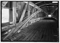
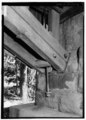
The West Union Covered Bridge formerly carried Tow Path Road over Sugar Creek north-northeast of Montezuma, Indiana. The two-span Burr Arch Truss covered bridge structure was built by Joseph J. Daniels in 1876. It is notable for being the longest standing covered bridge in Parke County, [4] [5] and one of the nation's best-preserved examples of the Burr truss. [6]

Contents

It was added to the National Register of Historic Places in 1978 [3] and was named a National Historic Landmark in 2016. [7]

History

The West Union Covered Bridge is the third bridge to stand at this location. The Star Mill Covered Bridge was the first and then the Harrison Covered Bridge replaced it but was damaged in 1876 prompting the West Union Covered Bridge to be built. The bridge was finished in September 1876. The road was originally part of the "Indiana State Highway", established with Legislature in 1827, which connected Fort Wayne with Terre Haute. Along with the Armiesburg Covered Bridge it hosted stage coach traffic to Lafayette.

Not much is left of West Union today, only a handful of houses. Gone are the school, post office, and the railroad. The Wabash Erie Canal ran just west of town with a feeder canal running south of Sugar Creek and connecting to the west of the bridge. The Chicago & Eastern Illinois Railroad crossed Sugar Creek to the east of the bridge and past West Union on the west side. Little is left of evidence of the railroad or the canal today. Farmers reclaimed the land and farm most of it today.

See also

Related Research Articles

<span class="mw-page-title-main">Hunsecker's Mill Covered Bridge</span> Bridge in Pennsylvania, United States

The Hunsecker's Mill Covered Bridge is a covered bridge located in Lancaster County, Pennsylvania, United States. The bridge has a single span, wooden, double Burr arch trusses design. The bridge, which spans the Conestoga River, is 180 feet (55 m) long, making it the longest single span covered bridge in the county.

<span class="mw-page-title-main">Mansfield Covered Bridge</span> Bridge in Indiana, United States

The Mansfield Covered Bridge is a Double Burr Arch double span truss bridge located on Mansfield Road (historic) and Big Raccoon Creek in Mansfield southeast of Rockville in Parke County, Indiana. Built by Joseph J. Daniels in 1867 at a cost of $12,200. At 279 ft (85 m) it is the second longest covered bridge left in Parke County. This Historic Site rest on land provided by Luke Moody, of Parke County, Indiana and is open to the public all year.

<span class="mw-page-title-main">Big Rocky Fork Covered Bridge</span> Place in Indiana listed on National Register of Historic Places

The Big Rocky Fork Covered Bridge is located 1 mile (1.6 km) southeast of Mansfield, Indiana, on County Road 720 and about 2 miles (3.2 km) east of State Road 59, in Parke County.

<span class="mw-page-title-main">Crooks Covered Bridge</span> Bridge in Parke County, Indiana

The Crooks Covered Bridge is a single span Burr Arch Truss structure that crosses Little Raccoon Creek built in 1855-1856 by Henry Wolf just southeast of Rockville, Indiana.

<span class="mw-page-title-main">Billie Creek Covered Bridge</span> Bridge in Parke County, Indiana

The Billie Creek Covered Bridge is a Burr Arch structure that was built by Joseph J. Daniels in 1895. J.L. Van Fossen supplied the sandstone that makes up the abutments cut from A.E. Fuel's nearby quarry.

<span class="mw-page-title-main">Cox Ford Covered Bridge</span> Bridge in Indiana, United States

The Cox Ford Covered Bridge is a covered bridge that crosses Sugar Creek along the western edge of Turkey Run State Park, in Parke County, in the U.S. state of Indiana.

<span class="mw-page-title-main">Jackson Covered Bridge</span> Place in Indiana listed on National Register of Historic Places

The Jackson Covered Bridge also known as the Rockport Covered Bridge is located in the 'forgotten town' of Rockport, northwest of Bloomingdale, Parke County, Indiana, USA.

<span class="mw-page-title-main">Leatherwood Station Covered Bridge</span> Place in Indiana listed on National Register of Historic Places

The Leatherwood Station Covered Bridge is a single span double Burr Arch Truss covered bridge structure that was built by Joseph A. Britton & Son in 1899. Originally it had sandstone abutments but when it was moved to Billie Creek Village they were replaced with concrete abutments with sandstone showing.

<span class="mw-page-title-main">Mecca Covered Bridge</span> Place in Indiana listed on National Register of Historic Places

The Mecca Covered Bridge crossing Big Raccoon Creek East of Mecca, Indiana is a single span Burr Arch Truss covered bridge structure that was built by J. J. Daniels in 1873. The bridge is 176 feet (54 m) long, 17 feet (5.2 m) wide, and 12.5 feet (3.8 m) high.

<span class="mw-page-title-main">Melcher Covered Bridge</span> Place in Indiana listed on National Register of Historic Places

The Melcher Covered Bridge, also known as the "Klondyke Covered Bridge", "Marion Covered Bridge", or the "Leatherwood Covered Bridge" crosses Leatherwood Creek east of Montezuma, Indiana, and is a single-span Burr Arch Truss covered bridge structure that was built by Joseph J. Daniels in 1896.

<span class="mw-page-title-main">Mill Creek Covered Bridge</span> Place in Indiana listed on National Register of Historic Places

The Mill Creek Covered Bridge also known as "Thompson's Ford Covered Bridge," "Tow Path Covered Bridge," or "Earl Ray Covered Bridge" crosses Wabash Mill Creek (historic) southwest of Tangier, Indiana. It is a single span Burr Arch Truss covered bridge structure that was built by D. M. Brown in 1907.

<span class="mw-page-title-main">Narrows Covered Bridge</span> Place in Indiana listed on National Register of Historic Places

The Narrows Covered Bridge crosses Sugar Creek at the eastern edge of Turkey Run State Park and is a single span Burr Arch Truss covered bridge structure that was built by Joseph A. Britton in 1882.

<span class="mw-page-title-main">Portland Mills Covered Bridge</span> Bridge in Indiana, United States

The Portland Mills Covered Bridge is the second oldest covered bridge in Parke County, Indiana, being built the same year as the Crooks Covered Bridge. It is a single span Burr Arch Truss covered bridge that was built by Henry Wolf in 1856.

<span class="mw-page-title-main">Phillips Covered Bridge</span> Place in Indiana listed on National Register of Historic Places

The Phillips Covered Bridge is southeast of Montezuma, Indiana in Parke County, Indiana and crosses Rocky Run, also known as Big Pond Creek. Unlike the rest of the bridges of Parke County, it is a single span King Post bridge structure, having no arches, that was built by Joseph A. Britton in 1909.

<span class="mw-page-title-main">Roseville-Coxville Covered Bridge</span> Bridge southeast of Mecca, Indiana

The Roseville Covered Bridge, also known as the Coxville covered bridge, is southeast of Mecca, Indiana. The double span Burr Arch covered bridge structure was built by Joseph J. Daniels in 1910. This is the third bridge at this location.

<span class="mw-page-title-main">Sim Smith Covered Bridge</span> Place in Indiana listed on National Register of Historic Places

The Sim Smith Covered Bridge is east of Montezuma, Indiana. The single span Burr Truss covered bridge structure was built by Joseph A. Britton in 1883. The bridge is 101 feet (31 m) long, 16 feet (4.9 m) wide, and 14 feet (4.3 m) high.

<span class="mw-page-title-main">Wilkins Mill Covered Bridge</span> Place in Indiana listed on National Register of Historic Places

The Wilkins Mill Covered Bridge is north of Rockville, Indiana. The single span Burr Arch Truss covered bridge structure was built by William Hendricks in 1906. The bridge is 120 feet (37 m) long, 16 feet (4.9 m) wide, and 13 feet (4.0 m) high.

<span class="mw-page-title-main">Zacke Cox Covered Bridge</span> Place in Indiana listed on National Register of Historic Places

The Zacke Cox Covered Bridge is east of Mecca, Indiana. The single span Burr Arch Truss covered bridge structure was built by Joseph A. Britton in 1908.

References

  1. "Bridge Information".
  2. "West Union Covered Bridge (#26)". Parke County Convention & Visitors Commission. Retrieved 16 January 2015.
  3. 1 2 "National Register Information System". National Register of Historic Places . National Park Service. January 23, 2007.
  4. "West Union Covered Bridge". Parke County Incorporated / Parke County Convention and Visitors Commission. Retrieved 2012-10-18.
  5. "Indiana State Historic Architectural and Archaeological Research Database (SHAARD)" (Searchable database). Department of Natural Resources, Division of Historic Preservation and Archaeology. Retrieved 2016-06-01.Note: This includes Charles Felkner (December 1977). "National Register of Historic Places Inventory Nomination Form: Parke County Covered Bridge Historic District" (PDF). Retrieved 2016-06-01. and Site map.
  6. "Draft NHL nomination for West Union Bridge" (PDF). National Park Service. Retrieved 2017-03-08.
  7. "Weekly list of actions 2/16/17 to 3/2/17". National Park Service. Retrieved 2017-03-08.
External video
Nuvola apps kaboodle.svg Fly-through of West Union Bridge, Spanning Sugar Creek, Montezuma, Indiana, HAER, September 10, 2014