2015–16 North American winter

Last updated • 25 min readFrom Wikipedia, The Free Encyclopedia

2015–16 North American winter
January 2016 United States winter storm 2016-01-22 0735Z.png
Satellite image of a historic blizzard bearing down on the Northeastern United States on January 22
Seasonal boundaries
Meteorological winterDecember 1 – February 29
Astronomical winterDecember 21 – March 20
First event startedNovember 20, 2015
Last event concluded April 17, 2016
Most notable event
Name January 2016 United States blizzard
  DurationJanuary 21–24, 2016
  Lowest pressure983  mb (29.03  inHg)
  Fatalities55 fatalities
  Damage$0.5–3 billion (2016 USD)
Seasonal statistics
Total storms (RSI)
(Cat. 1+)
3 total
Major storms (RSI)
(Cat. 3+)
1 total
Maximum snowfall accumulation51.3 in (130 cm) at Pinecliffe, Colorado
(April 15–23, 2016)
Maximum ice accretion1.5 in (38 mm) in Eakly, Oklahoma
(November 25–27, 2015)
Total fatalities117 total
Total damage$4.7–7.2 billion (2016 USD)
Related articles
North American winters

The 2015–16 North American winter was not as frigid across North America and the United States (especially the East Coast) as compared to the 2013–14 and 2014–15 winters. This was mainly due to a strong El Niño, which caused generally warmer-than-average conditions. However, despite the warmth, significant weather systems still occurred, including a snowstorm and flash flooding in Texas at the end of December and a large tornado outbreak at the end of February. The main event of the winter season, by far and large, was when a crippling and historic blizzard struck the Northeastern United States in late January, dumping up to 3 feet (36 in; 91 cm) of snow in and around the metropolitan areas. Several other smaller snow events affected the Northeast as well, but for the most part the heaviest snowstorms and ice stayed out further west, such as a severe blizzard in western Texas in late December (producing a tornado outbreak as well), and a major late-season snowstorm in Colorado in mid-April.

Contents

While there is no well-agreed-upon date used to indicate the start of winter in the Northern Hemisphere, there are two definitions of winter which may be used. Based on the astronomical definition, winter begins at the winter solstice, which in 2015 occurred late on December 21, and ends at the March equinox, which in 2016 occurred on March 20. [1] Based on the meteorological definition, the first day of winter is December 1 and the last day February 29. [2] Both definitions involve a period of approximately three months, with some variability. Winter is often defined by meteorologists to be the three calendar months with the lowest average temperatures. Since both definitions span the calendar year, it is possible to have a winter storm in two different years.

Seasonal forecasts

US temp outlook winter 2015-16 NOAA.jpg
Temperature outlook
US precip outlook winter 2015-16 NOAA.jpg
Precipitation outlook

On October 15, 2015, the National Oceanic and Atmospheric Administration's Climate Prediction Center issued its U.S. Winter Outlook. The presence of a strong El Niño event was expected to affect weather and climate patterns by influencing the position of the Pacific jet stream. According to CPC deputy director Mike Halpert at the time of the outlook, "A strong El Niño is in place and should exert a strong influence over our weather this winter" and "While temperature and precipitation impacts associated with El Niño are favored, El Niño is not the only player. Cold-air outbreaks and snow storms will likely occur at times this winter. However, the frequency, number and intensity of these events cannot be predicted on a seasonal timescale." Other oscillations anticipated to have some effect on winter in the United States were the Arctic oscillation and the Madden–Julian oscillation. The precipitation outlook indicated an elevated likelihood of above-average levels precipitation from central and southern California to Texas and Florida and northward to southern parts of New England. Above-average precipitation was also favored in southeastern Alaska, with below-average levels of precipitation favored in central and western Alaska, parts of the Northwestern U.S. and northern Rocky Mountain states, and areas in the vicinity of the Great Lakes and Ohio Valley.

The temperature outlook favored below-average temperatures in the southern Plains and Southeastern United States. Above-average temperatures were most favored across the West and the northern half of the contiguous United States and Alaska and Hawaii. The drought outlook anticipated improvement in conditions in central and southern California by the end of January 2016, noting the possibility of additional alleviation of drought conditions in February and March. The outlook favored the removal of drought across large parts of the Southwestern U.S., with additional lessening or elimination of drought conditions likely in the southern Plains. Drought conditions were expected to persist across the Pacific Northwest and northern Rocky Mountains, with development likely in Hawaii and areas in the vicinity of the northern Great Lakes region. [3]

On November 30, 2015, Environment Canada issued its winter outlook for December, January, and February, as part of their monthly climate outlooks. Above-average temperatures were favoured throughout most of Canada, with the exception of northern Quebec and the southern tip of Baffin Island; areas that were considered the most likely to see above normal temperatures included the Lower Mainland of British Columbia, the Maritime provinces, southern Newfoundland, central Quebec and Ontario, and northern Manitoba and Saskatchewan; in those areas, the probability of above-normal temperatures was over 80%. The areas where below-normal temperatures were favoured included extreme northern areas of Quebec and Labrador, along with southern parts of Baffin Island. Above average precipitation was favoured in the Lower Mainland of B.C., New Brunswick, northern Quebec, northern Newfoundland, the Northwest Territories, and western Nunavut. Below-average precipitation was favoured on the south-eastern tip of Baffin Island and a small area just north of Lake Superior. [4]

Seasonal summary

April 2016 North American storm complexLate March 2016 North American blizzardTornado outbreak of February 23–24, 2016#Non-tornadic impactsEarly February 2016 nor'easterFebruary 2016 North American winter stormJanuary 2016 United States blizzardDecember 2015 North American storm complexRegional Snowfall Index2015-16 North American winter
A winter storm moves through the Midwest, on March 23. March2016Blizzard.png
A winter storm moves through the Midwest, on March 23.

The winter of 2015–16 was quite unusual and historic in terms of winter weather. First, around the end of November near Black Friday, a crippling ice storm hit the Southern and Central Plains with as much as 1.5 inches (38 mm) of ice accumulation in some areas, knocking out power to over 100,000 residents. [5] In December, two winter storms impacted the Great Lakes, with the latter one being a bit farther to the west, both brought roughly a foot of snow in some locations. Normally, in this area, this is not common, but the strong El Niño may have been a contributor to this. Following that, the nation had one of the warmest Decembers on record, with New York City being as warm as 72 °F (22 °C) on Christmas Eve (December 24). [6] This was the warmest temperature in New York City in the second half of December on record. [7] The low that day of 63 °F (17 °C) was the warmest December low on record in New York. [8] In fact, across the Lower 48, this was the warmest and wettest December on record at the time. Every single state in the Northeastern United States saw a record warm December. [9] In 2021, an even warmer December was recorded across the Lower 48, with a mean temperature of 39.3 °F (4.1 °C) rather than 38.6 °F (3.7 °C). [10] This meant Buffalo, New York until December 18, a record for latest first snow. [11] A strong tornado outbreak also occurred from December 23–25, which a very similar event had occurred the year before, just weaker. [12] After this system passed, a larger storm complex moved through the same areas impacted by the ice storm from Black Friday 2015. This storm brought blizzard conditions to parts of Texas and New Mexico, with areas reaching up to close to 2 feet of snow in parts of Texas, which is a rare event in that state. [13] For comparison, the last time this has occurred (or near the same areas), was in 2011 during the Groundhog Day blizzard.

Average temperature anomaly for the winter in the United States. Not one state had below-average temperatures. 2015-16WinterTemperatures.gif
Average temperature anomaly for the winter in the United States. Not one state had below-average temperatures.

The month of January 2016 was variable in its weather patterns. Following the warm trend in December, an early cold snap brought close-to-average temperatures to the East Coast, at the same time a storm complex was moving through the Northeast, and due to the fresh batch of cold air, it was able to produce some snow on the back side of it. [14] At the opposite end of the spectrum, the West Coast was receiving needed rainfall to help during its long-time drought. This brief period of relief soon ended. After that, around January 16–17, a potent storm system moved up the East Coast, bringing the first snowfall of the season to areas like Philadelphia and New York City. A few days later, an Alberta clipper moved through the central United States, producing a swath of snow from Illinois to North Carolina. This small system was then proceeded and eclipsed by a crippling and historic blizzard just days later on January 22–23. Cities like Washington D.C., Philadelphia, and New York City were buried with 1–2.5 feet (12–30 in) of snow, breaking numerous records. [15]

In February, the historic weather events continued, as another snowstorm kicked off the month with a swath of snow from Colorado to Michigan. Snow accumulations ranged from 8–14 inches (20–36 cm), along with winds up to 45 mph (72 km/h). [16] After the storm system passed, its cold front transformed into another potent snowstorm for the East Coast, with snowfall amounts up to 8 inches. [17] From there, another winter storm occurred as a nor'easter, bringing more snow to New England on February 8. [18] Shortly thereafter, the coldest air of the season froze parts of the Northeast on February 14, with temperatures dipping to as low as 0 °F (−18 °C), shattering many record low temperatures. [19] The cold lingered into Presidents Day as another winter storm began to take shape. This set the stage for more snow in the Northeast. Snowfall ranged anywhere from 4–6 inches (10–15 cm) in the Northeast, to 12–18 inches (30–46 cm) in the Appalachians. [20] What was interesting about the weather pattern for this system, was the 24-hour weather difference, for example, at 2:00 pm EDT on February 15, New York City reported snow with temperatures in the 30s, and a day later, reported temperatures in the mid-50s and thunderstorms on February 16. The system departed by February 17. A week later around February 22–24, another winter storm formed and eventually produced the second-largest tornado outbreak ever recorded in February. [21] The storm complex produced as much as 59 confirmed tornadoes, with 4 of them being rated an EF3, including areas which don't normally see tornadoes that strong. The massive system moved out of the United States by February 25.

March was quite extreme. Around March 10, an area of low pressure in the upper levels of the atmosphere dove into Mexico, where it stalled for a few days, and caused some extreme and record-breaking weather events from March 7–10. Parts of the South were inundated with days of heavy rain, with areas receiving more than 18 inches of rain, leading to historic flash flooding. [22] At the same time, record-breaking temperatures pushed into the Northeast, with some areas reaching into the low 80s (which broke the record for earliest 80 degree day on record). The storm system also produced snow in Mexico, which rarely receives it at all. Around the spring equinox, winter was still not done. A weak nor'easter formed on March 20, and tracked up the East Coast later that day, producing a swath of snow up to 10 inches in some spots. [23] The nor'easter was predicted to be stronger than what was actually observed, but due to computer models, direction of the low pressure, and amount of cold air present made it difficult to precisely time the storm out. The storm then went on to enter the Arctic Ocean where it explosively deepened to a minimum of 949 millibars (28.0 inHg) on March 23. That same day, another winter storm began to produce blizzard conditions in the High Plains, and dropped up to 30 inches (76 cm) of snow in parts of the High Plains and the Great Lakes through March 23–25, along with bringing a significant ice storm to parts of New England, with accumulations of 0.25–0.75 inches (6.4–19.1 mm) of ice in some areas. [24]

Even though winter was officially over, it felt like winter somewhat in the Northeast. An unusual cold blast occurred at the beginning of April, bringing temperatures 10–15 °F (−12 – −9 °C) below average in the afflicted areas. [25] It was cold enough for snow in parts of New England, and as a result, several Alberta clippers began to track their way to the East Coast. The first clipper brought mainly high winds and snow showers to much of the Northeast early on April 3, with mainly high wind warnings being issued. [26] This system moved off rather quickly and immediately began undergoing bombogenesis, with its pressure dropping to 984 millibars (29.1 inHg) by 12 UTC, less than 3 hours after the centre had moved off the coast. It then went to further deepen to a peak of 954 millibars (28.2 inHg) late on April 4. The next clipper system was weaker, but brought a swath of accumulating snow to the southeastern parts of New England. It later moved off late that night. [27] A third clipper system began to edge its way into the Great Lakes on April 6, and brought the risk for wildfires as well. It moved into Canada while transitioning into a storm complex on April 7. A fourth system then moved across nearly the same areas from April 8–9, bringing even more spring snow to the Mid-Atlantic states. This system actually intensified into a small nor'easter on April 9, and brought 1–3 inches (2.5–7.6 cm) of wet snow from the Ohio Valley into the Northeast. It moved off later that night, but brought some more cold air with it. Finally, the cold air retreated out of the region by April 11–12, as warm air began to surge back in. However, winter made one last comeback during the weekend of April 16–17, as an upper-level low stalled in the West, producing a major snowstorm that affected the High Plains and Rocky Mountains in areas near the Denver metropolitan area, dumping up to 4 feet (48 in) of heavy snow, which led to power outages. [28] The storm also produced record rainfall of up to 20 inches (51 cm), leading to severe flash floods. The system moved slowly eastward, as a developing Omega Block pattern was expected to bring extreme relief to the cold stricken Midwest and East Coast.

Events

Late November ice storm

Around Black Friday of 2015, a major ice storm occurred in the Southern Central Plains, with areas receiving up to 1 inch (25 mm) of the frozen precipitation. Residents in the areas were without powers for days, if not weeks. The storm also brought snow to parts of the Midwest, with accumulations up to 1 foot (30 cm) of snow. [29] Historic rainfall also fell too, breaking numerous records. [30] On November 25, an area of low pressure system moved through the West and central Midwest, dropping snow of up to 1 foot (30 cm), [29] and also brought the first cold blast of the winter season. At the same time, incoming moisture from weakening Hurricane Sandra in the East Pacific was starting to streak through Mexico into the southwestern United States. Interacting with the low pressure area, this combined to produce a plume of precipitation from ice to rain from southern Texas into Minnesota, due to high pressure situated off Maine keeping the Northeast dry for the holiday.

While causing a potent ice storm on its cold side, on the warm sector of the system, severe floods occurred as well, with areas like McKinney in Texas receiving up to 10.53 inches (26.7 cm) of rain over a 4-day period, causing major flooding. [30] Some areas even broke their records for yearly rainfall totals from this system, due to the axis of moisture shooting into Canada. [30] In total, 17 people died, including six in Kansas, three in Texas, three in Missouri and one in Utah, and over 110,000 left without power, especially around Oklahoma City. [31]

Post-Christmas storm complex

Satellite image of a large storm complex over the Southern United States late on December 26 Southern US storm complex Dec 26 2015 2230 UTC.jpg
Satellite image of a large storm complex over the Southern United States late on December 26

Two days after Christmas, a large storm complex with snow, severe weather and heavy rainfall impacted the Southern Plains and southern Rocky Mountains, including all or parts of the states of Colorado, New Mexico, Texas and Oklahoma. The system spawned tornadoes over central and eastern Texas and Oklahoma, while bringing blizzard conditions to the Texas and Oklahoma panhandles, most areas in New Mexico, and southern Colorado. The main area of low pressure moved northeast from the southern Plains to the eastern Great Lakes, while a secondary low pressure system formed east of the Delmarva Peninsula on December 29. After impacting New Mexico and the Texas panhandle with record snowfall, the storm system left a swath of snow and ice accumulation from western Oklahoma to Michigan. On December 29, the storm system brought a mix of snow, sleet and freezing rain to New York State and New England.

On December 26, 2015, it affected parts of the Texas Panhandle and resulted in the formation of tornadoes in the Dallas area, including an EF4 which struck the Garland area that evening. [32] [33] [34]

Late January blizzard

An intensifying winter storm off the East Coast early on January 23. January 2016 United States winter storm 2016-01-23 0715Z (alternate).jpg
An intensifying winter storm off the East Coast early on January 23.

A crippling and historic blizzard occurred from January 22–23 in the Mid-Atlantic states. The storm was given various unofficial names, including Winter Storm Jonas, Blizzard of 2016, and Snowzilla among others. The highest reported snowfall was 40 inches (100 cm) in Glengary, West Virginia. Locations in five states exceeded 30 inches (76 cm) of snow. The storm dropped 18 inches (46 cm) of snow in Washington, D.C., 22 inches in Philadelphia, 26 inches (66 cm) in Baltimore, 30.5 inches (77 cm) in New York City. [35] [36] [37] States of emergency were declared in Maryland, North Carolina, Pennsylvania, Tennessee, West Virginia, Virginia, Delaware, New York, and Washington, D.C. [38] The storm also caused coastal flooding in Delaware and New Jersey. Cape May, New Jersey set a record high water level at 8.98 feet (2.74 m), higher than the 8.90 feet (2.71 m) seen during Hurricane Sandy. [35] High winds led to blizzard conditions in many areas. Sustained winds of 59 miles per hour (95 km/h) with gust of 72 mph (116 km/h) were recorded in Delaware. 70 miles per hour (110 km/h) gusts were also recorded in Massachusetts. [35]

Early February winter storm

A trailing low pressure system to the previous weeks' blizzard had developed offshore California on January 29. The low and accompanying precipitation moved onshore the next day. At the time blizzard conditions were expected. The storm moved eastward into the Great Plains where tremendous snowfall occurred. On February 1, another area of low pressure led to severe weather across the Southeastern United States. Multiple tornadoes were reported in Alabama, Mississippi and Tennessee, including a large EF2 tornado. After the storm had passed, the cold front associated with it stalled over the East Coast late on February 4. A new low pressure developed off North Carolina that night and started to track up the coast. It impacted areas already hit hard by the previous blizzard about two weeks prior, and caused messy travel along Interstate 95 (Northeast). The storm brought a quick but moderate-to-heavy burst of steady snow, with some areas in New England receiving up to 1 foot (0.30 m).

February nor'easter

On February 7, an elongated area of low pressure developed offshore to the west of Florida. While moving inland, it produced a decent dose of rainfall to the Sunshine State as it moved to the northeast. Later the same day, it moved offshore into the Atlantic Ocean and began to undergo bombogenesis, its pressure dropping from 1,004 millibars (29.6 inHg) at 7 a.m. EST February 7 to 979 millibars (28.9 inHg) at 1 a.m. EST February 8. [39] As it did so, it also began to transition into a nor'easter, as rainbands began to impact the eastern edges of North Carolina and South Carolina. There was some cold air aloft, allowing for a few areas of wet snow to develop further inland. As the cyclone continued to strengthen, it started to achieve the conditions of a bomb cyclone. Furthermore, the system started to form an eye compared to that of a typical Category 1 hurricane, however this was short-lived and dissolved a few hours later. Snowbands began to impact New England early in the morning of February 8, with some bands reaching up to snowfall rates of an inch per hour, especially near the coast. The outermost bands did not reach New Jersey and New York City, due to the nor'easter being far offshore. The storm continued to deepen for a few more hours before reaching its peak intensity of 976 millibars (28.8 inHg). The system then continued to weaken as it moved northward, before finally merging with another low pressure system on February 10 to the south of it which had also exited from the East Coast.

Mid-February cold wave

Predicted average temperature departure for Sunday, Feb. 14. Note the large area of dark blue and purple over the Northeast, signifying very cold temperatures. ColdTemperaturesFeb142016.jpg
Predicted average temperature departure for Sunday, Feb. 14. Note the large area of dark blue and purple over the Northeast, signifying very cold temperatures.

During mid-February, record-breaking cold temperatures swung across the Northeast United States and southeastern Canada. [40] On 13 February 2016, Whiteface Mountain underwent a record windchill of −114 °F (−81 °C), [41] while in Boston, Massachusetts, the temperature dropped to −9 °F (−23 °C), the coldest since 1957. The windchill descended to −36 °F (−38 °C), surpassing the previous record by 6 °F (−14 °C). [42] In Toronto, Ontario, the NBA All-Star Weekend took place in temperatures of −23 °C (−9 °F) and wind chills near −40 °C (−40 °F), causing some players and visitors to complain about the cold. [43] The recorded temperatures were the coldest recorded since a very similar cold wave impacted the region exactly a year prior. In New York City, the temperature in Central Park gets below 0 °F (−18 °C) for the first time since January 19, 1994, [44] and the windchill at JFK Airport on February 14 at 6:30am hit −19 °F (−28 °C). The low of −1 °F (−18 °C) set a record for the coldest Valentines Day on record. [45] Bridgeport, Connecticut experienced its coldest February temperature, and 2nd coldest all time temperature, at −6 °F (−21 °C). [46] Meanwhile, Binghamton hit −18 °F (−28 °C). Windchills in Worcester, Massachusetts sunk to −44 °F (−42 °C). [47]

In spite of −1 °F (−18 °C) temperatures in New York on February 14, by February 16, the temperature reached 54 °F (12 °C). [48] Meanwhile, despite Toronto having a windchill on February 14 of −34 °C (−29 °F), the next day it felt like −1 °C (30 °F). [49]

Late February tornado outbreak

On February 23, a low-pressure area developed near the east end of Texas and began to track northeastwards into the Mid-Atlantic States in the early hours of February 24. During this period, it also began to interact with some cold air on the back side of it, producing snow and ice in parts of the Ohio Valley, dumping as much as 17.0 inches (43 cm) of snow. [50] At the same time, ahead of the cold front, severe thunderstorms developed ahead of it, which would eventually lead to the second largest tornado outbreak of the month of February.

March extreme weather events

NASA satellite image of the storm system responsible for the record flooding in the South and record warmth in the Northeast. Taken March 10, 2016. Sat-mar10-viirs.jpg
NASA satellite image of the storm system responsible for the record flooding in the South and record warmth in the Northeast. Taken March 10, 2016.

On March 7, an area of low pressure system from the Pineapple Express moved ashore in California as part of the pattern change that allowed the Golden State to receive much-needed rain. Late that evening, it dove into Mexico where it became detached from the main jet stream. [51] It then stalled for a few days and caused some extreme weather events, such as record-breaking heat in the Northeast, with areas achieving their earliest 80 °F (27 °C) day on record, which was the result of high pressure off the coast of Florida. It also caused historic floods in the South as well. Areas in Louisiana picked up to over 15 inches (38 cm) of rain, setting numerous records and triggering multiple flash floods from the extreme rainfall. The highest rainfall report was 23.22 inches (59.0 cm) near Monroe in Louisiana. [52] The historic events also caused rare snow in Mexico, which rarely receives snow at all. [51]

Late March blizzard

On March 21, an area of low pressure moved ashore on the West Coast, with a limited amount of moisture available. Because of this precipitation was originally isolated. As it moved eastward on March 22 it started to intensify and as such snowfall began to become widespread. The storm also began to transition into an extratropical cyclone, achieving a peak of 989 millibars (29.2 inHg) two times on March 23. [53] Blizzard warnings were issued for areas around Denver due to the strong winds accompanying the system along with snowfall. Parts of Interstate 80 were shut down due to the extreme winter weather conditions. [54] During the storm, Denver International Airport was shut down. [55] Ahead of its cold front, thunderstorms began to fire up, prompting the National Weather Service to issue a tornado watch. A squall line later developed out of this as more storms began to fire up and move eastwards, with the severe weather threat shifting more to the east towards the East Coast. [56] The system also brought ice accumulations from 0.25–0.75 inches (6.4–19.1 mm) from the Midwest into New England. It then rapidly weakened and moved offshore late on March 25, dissipating the next day.

Early April clippers and cold wave

In the beginning of April, an unusual blast of cold air rushed into the Northeast, bringing temperatures 10–30 °F (5.6–16.7 °C) below average for most of the area. [25] Some areas even broke records for lowest April low temperatures. This was paired with a series of Alberta clippers moving through the Great Lakes through the weekend of April 2–3. [57] The first clipper brought mainly high winds with it, knocking out power to a few thousand. This clipper then moved off the East Coast the same day and immediately began strengthening, its pressure dropping to 984 millibars (29.1 inHg) early on April 3, then further deepening to 954 millibars (28.2 inHg) on April 5.

The next clipper system was weaker than the previous one, alias only reaching a peak of 997 millibars (29.4 inHg) early on April 3, however, gained enough characteristics to become a full-fledged winter storm. Moving fairly quickly, this snowmaker began to drop snow near the Great Lakes at its peak intensity, and as it neared the Northeast, snow began to spread eastward. Early on April 4, light to moderate snow had reached Boston, with locally heavier snowfall rates at times, which made visibility low. [27] By mid-day, rainfall began to fire up along the clipper's cold front, spreading into New York City and New Jersey. This forced the New York Yankees to postpone their home openers against the Houston Astros. [58] It began to accelerate at the same time, moving off the coast late the same day. Total snowfall accumulations from this system ranged from 2–6 inches (5.1–15.2 cm), in a swath extending from the Great Lakes into southeastern New England. [27] Providence, Rhode Island set a daily record for snow at 5.9 inches (15 cm), as well as a daily record for coldest high on the date at 31 °F (−1 °C). [59] The 6.4 in (16 cm) of snow at Albany, New York resulted in April being the snowiest month of the year. [60] The winter storm led to a crash on Interstate 88. [61] After the storm, Ithaca, New York set a monthly record low of −1 °F (−18 °C). [62] Several cities in northern Maine also broke monthly record lows. [63] A third system began plowing into the same areas on April 5–6, bringing more snow to the Great Lakes, and also the risk of wildfires in the Southwest. [57] This clipper transitioned into a storm complex early on April 7, and brought heavy rain to parts of the New York metropolitan area. It lingered into early April 8 before finally retreating into Canada. A fourth clipper system reached the Mid-Atlantic states by the weekend of April 9–10, and brought both cold temperatures with it, and a swath of accumulating snow of 3–6 inches (7.6–15.2 cm) from the Ohio Valley into the southern parts of New Jersey. [57] The fourth clipper postponed a Baltimore Orioles game. [64] As it approached the coastline, it began to transition into a small nor'easter. Because of temperatures being at or just above freezing, pockets of wet snow broke out in central New Jersey, with only accumulations on grassy surfaces, but areas further to the south picked up to 1–2 inches (2.5–5.1 cm), [57] including Atlantic City at 1.8 inches (4.6 cm). [65] The system moved offshore late by April 9, but brought some more cold temperatures behind it, setting more record lows. Due to the cold brought by the system, wind chills at Nationals Park hovered in the upper 20s and lower 30s. This forced a game between the Miami Marlins and Washington Nationals to postpone. [66]

The cold wave finally lifted out of the Northeastern United States by April 12, due to an imminent pattern change that would allow warm air to surge back into the region. [67]

Mid-April storm complex

On April 13, an area of disturbed weather associated with the jet stream moved ashore on the West Coast. Moving slowly it dived into the High Plains and Rocky Mountains during the course of the day on April 14. The upper-level low associated began to stall in the area and became cut off from the jet stream, while simultaneously producing a major snowstorm in the Rocky Mountains (with up to as much as 4 feet (48 in) of snowfall reported) and areas around the Denver metropolitan area and soaked the Central Plains and areas to the south with heavy rain (up to 20 inches (51 cm) of rainfall was reported early on April 18), flooding, severe thunderstorms, and possibly tornadoes. [68] [69] [70] Multiple rescue efforts had to be made in southeastern Texas early on April 18, due to the extremely heavy rainfall and flooding. [71] [72] The upper low gradually moved out of the region by April 19, alas at a very slow rate.

Records

This is a list of records broken in North America during the 2015–16 winter.

United States

Season effects

This is a table of all of the events that have occurred in the 2015–16 North American winter. It includes their duration, damage, impacted locations, and death totals. Deaths in parentheses are additional and indirect (an example of an indirect death would be a traffic accident), but were still related to that storm. All of the damage figures are in 2016 USD.

Regional Snowfall Index scale
C0C1C2C3C4C5
2015–16 North American winter season statistics
Event
name
Dates active RSI categoryRSI valueHighest
gust
mph (km/h)
Minimum
pressure
(mbar)
Maximum
snow
in (cm)
Maximum
ice
in (mm)
Areas affectedDamage
(2016  USD)
Deaths
Late November ice stormNovember 25 – 27N/AN/AN/AN/A12 (30)1 (25) Central United States Unknown17
Post-Christmas storm complex December 26 – 29N/AN/AN/A98941 (104)N/A Southwestern, Central, and New England regions in the United States (particularly Texas); Northern Mexico; Southeastern Canada >$3 billion21
Late January blizzard January 21 – 23Category 520.1485 (135)98342 (110)0.75 (19) Pacific Northwest, Great Plains, South Central United States, Eastern United States (especially the Mid-Atlantic states), Atlantic Canada, British Isles, Finland $500 million – $ 3 billion55
Early February winter storm January 30 – February 7Category 24.68N/AN/A41 (100)N/A Western United States, Central United States, Southeastern United States, Northeastern United States Unknown7
Early February nor'easter February 6 – 9N/AN/A65 (105)97611 (28)N/ANortheastern United States, Atlantic Canada UnknownN/A
Late February tornado outbreak & winter storm February 23 – 24N/AN/AN/AN/A17 (43)0.7 (18) Eastern United States, Canada $1.2 billion7
Late March blizzard March 21 – 25N/AN/AN/A98932.5 (83)N/A Northeastern United States, Canada Unknown2
Mid-April storm complex April 16 – 17N/AN/AN/A100651.3 (130)N/A Western United States (Rocky Mountains)Unknown8
Season aggregates
3 RSI stormsNovember 20 – April 1797651.3 (130)1.5 (38)≥ $$4.7–7.2 billion117

See also

Related Research Articles

<span class="mw-page-title-main">Blizzard</span> Type of snowstorm

A blizzard is a severe snowstorm characterized by strong sustained winds and low visibility, lasting for a prolonged period of time—typically at least three or four hours. A ground blizzard is a weather condition where snow is not falling but loose snow on the ground is lifted and blown by strong winds. Blizzards can have an immense size and usually stretch to hundreds or thousands of kilometres.

<span class="mw-page-title-main">1993 Storm of the Century</span> Category 5 noreaster in the United States

The 1993 Storm of the Century was a cyclonic storm, or nor'easter, that formed over the Gulf of Mexico on March 12, 1993. The cold weather, heavy snowfall, high winds and storm surges that the storm brought affected a very large area; at its height, it stretched from Canada to Honduras. The cyclone moved through the Gulf of Mexico and then through the eastern United States before moving on to eastern Canada. It eventually dissipated in the North Atlantic Ocean on March 15.

<span class="mw-page-title-main">Weather of 2008</span>

Global storm activity of 2008 profiles the major worldwide storms, including blizzards, ice storms, and other winter events, from January 1, 2008, to December 31, 2008. A winter storm is an event in which the dominant varieties of precipitation are forms that only occur at cold temperatures, such as snow or sleet, or a rainstorm where ground temperatures are cold enough to allow ice to form. It may be marked by strong wind, thunder and lightning, heavy precipitation, such as ice, or wind transporting some substance through the atmosphere. Major dust storms, Hurricanes, cyclones, tornados, gales, flooding and rainstorms are also caused by such phenomena to a lesser or greater existent.

<span class="mw-page-title-main">2014–15 North American winter</span> Winter season in North America

The 2014–15 North American winter was frigid and prolifically wintry, especially across the eastern half of North America in the months of January–March. The season began early, with many places in North America experiencing their first wintry weather during mid-November. A period of below-average temperatures affected much of the contiguous United States, and several records were broken. An early trace of snowfall was recorded in Arkansas. There were greater accumulations of snow across parts of Oklahoma as well. A quasi-permanent phenomenon referred to as the polar vortex may have been partly responsible for the cold weather. Temperatures in much of the United States dropped 15 to 35 °F below average by November 19, following a southward "dip" of the polar vortex into the eastern two-thirds of the country. The effects of this dip were widespread, bringing about temperatures as low as 28 °F (−2 °C) in Pensacola, Florida. Following a significant snowstorm there, Buffalo, New York received several feet of snow from November 17–21. In addition, significant winter weather occurred throughout the season, including a major blizzard that struck the Northeastern United States at the end of January, another blizzard that affected much of the Northern United States days later in early February, and several significant snow events paired with very frigid temperatures for much of February.

<span class="mw-page-title-main">January 31 – February 2, 2015 North American blizzard</span>

The January 31 – February 2, 2015 North American blizzard was a major winter storm that plowed through the majority of the United States, dumping as much as 2 feet (24 in) of new snowfall across a path from Iowa to New England, as well as blizzard conditions in early February 2015. It came less than a week after another crippling blizzard which impacted the Northeast with 2–3 feet of snow. It was the first of many intense winter storms to occur in the nation during the month of February, partly in due to an ongoing cold wave that was beginning to take shape shortly after the storm subsided.

<span class="mw-page-title-main">2012–13 North American winter</span>

The 2012–13 North American winter started out somewhat early, as the remnants of Hurricane Sandy brought heavy snow to the mountains of West Virginia in late October. Later, a strong nor'easter affected the weary Northeastern United States, hampering storm recovery efforts and dropping several inches of snow. The rest of the winter featured several other notable events, such as a Christmas winter storm that affected most of the Eastern United States, and the most notable event occurring in early February, when a powerful blizzard struck the Northeast and brought record snow to some areas. During the winter, a weak El Nino was expected to influence weather conditions across the continent.

<span class="mw-page-title-main">2011–12 North American winter</span>

The 2011–12 North American winter by and large saw above normal average temperatures across the continent, with the Contiguous United States encountering its fourth-warmest winter on record, along with an unusually low number of significant winter precipitation events. The primary outlier was Alaska, parts of which experienced their coldest January on record.

<span class="mw-page-title-main">2009–10 North American winter</span>

The 2009–10 North American winter saw several major blizzards affect the Northeastern United States. It refers to winter as it occurred across the North American continent from late 2009 to early 2010. While there is no well-agreed-upon date used to indicate the start of winter in the Northern Hemisphere, there are two definitions of winter which may be used. Based on the astronomical definition, winter begins at the winter solstice, which in 2009 occurred on December 21, and ends at the March equinox, which in 2010 occurred on March 20. Based on the meteorological definition, the first day of winter is December 1 and the last day February 28. Both definitions involve a period of approximately three months, with some variability.

<span class="mw-page-title-main">2010–11 North American winter</span>

The 2010–11 North American winter was influenced by an ongoing La Niña, seeing winter storms and very cold temperatures affect a large portion of the Continental United States, even as far south as the Texas Panhandle. Notable events included a major blizzard that struck the Northeastern United States in late December with up to 2 feet (24 in) of snowfall and a significant tornado outbreak on New Year's Eve in the Southern United States. By far the most notable event was a historic blizzard that impacted areas from Oklahoma to Michigan in early February. The blizzard broke numerous snowfall records, and was one of the few winter storms to rank as a Category 5 on the Regional Snowfall Index. In addition, Oklahoma set a statewide low temperature record in February.

<span class="mw-page-title-main">2016–17 North American winter</span> Winter season in North America

The 2016–17 North American winter was quite warm across North America in general, due in part to a weak La Niña that was expected to influence weather conditions across the continent. Several notable events occurred during the season, including a potent winter storm that affected the East Coast of the United States in early January, the second-largest winter tornado outbreak on record later that month, and an unusually warm February. In addition, towards the end of the season, a large cyclonic storm system that caused a large tornado outbreak, flooding, and a potent blizzard occurred in the Heartland of the country. However, the most notable event of the winter was a powerful blizzard that impacted the Northeast and New England in mid-March, towards the end of the season.

<span class="mw-page-title-main">February 9–11, 2017 North American blizzard</span> Winter weather event

The February 9–11, 2017 North American blizzard was a fast-moving but powerful blizzard that affected the Northeastern United States with winter weather in the time span of February 8–9. Forming as an Alberta clipper in the northern United States, the system initially produced light snowfall from the Midwest to the Ohio Valley as it tracked southeastwards. It eventually reached the East Coast of the United States and began to rapidly grow into a powerful nor'easter. Up to 18 inches (46 cm) of snow as well as blizzard conditions were recorded in some of the hardest hit areas before the system moved away from the coastline early on February 10.

<span class="mw-page-title-main">2017–18 North American winter</span> Weather summary

The 2017–18 North American winter saw weather patterns across North America that were very active, erratic, and protracted, especially near the end of the season, resulting in widespread snow and cold across the continent during the winter. Significant events included rare snowfall in the South, an outbreak of frigid temperatures that affected the United States during the final week of 2017 and early weeks of January, and a series of strong nor'easters that affected the Northeastern United States during the month of March. In addition, flooding also took place during the month of February in the Central United States. Finally the winter came to a conclusion with a powerful storm system that caused a tornado outbreak and blizzard in mid-April. The most intense event, however, was an extremely powerful cyclonic blizzard that impacted the Northeastern United States in the first week of 2018. Similar to the previous winter, a La Niña was expected to influence the winter weather across North America.

<span class="mw-page-title-main">2018–19 North American winter</span> North American winter of 2018–19

The 2018–19 North American winter was unusually cold within the Northern United States, with frigid temperatures being recorded within the middle of the season. Several notable events occurred, such as a rare snow in the Southeast in December, a strong cold wave and several major winter storms in the Midwest, and upper Northeast and much of Canada in late January and early February, record snowstorms in the Southwest in late February, deadly tornado outbreaks in the Southeast and a historic mid-April blizzard in the Midwest, but the most notable event of the winter was a record-breaking bomb cyclone that affected much of the Central United States and Canada in mid-March. Unlike previous winters, a developing weak El Niño was expected to influence weather patterns across North America. Overall, however, winter of 2018–19 had many La Niña like conditions, being mild along the mid- and lower parts of the East Coast, the West Coast, and most of the southern Plains. Overall, the meteorological winter of 2018-19 became the wettest on record for the United States.

<span class="mw-page-title-main">2019–20 North American winter</span> Winter season in North America

The 2019–20 North American winter was unusually warm for many parts of the United States; in many areas, neutral ENSO conditions controlled the weather patterns, resulting in strong El Niño like conditions and the sixth-warmest winter on record, and many areas in the Northeastern United States saw one of the least snowy winters in years. In fact, Baltimore and Islip saw no snow in February for the first time. Some notable events still occurred, such as a powerful blizzard that impacted the Western United States in late November, a series of cold shots in January and February, a snowstorm within the Texas Panhandle and a late-season blizzard in the High Plains.

<span class="mw-page-title-main">2020–21 North American winter</span> Winter season in North America

The 2020–21 North American winter was the most significant winter season to affect North America in several years, and the costliest on record, with a damage total of at least $33.35 billion. The season featured six storms ranking on the Regional Snowfall Index scale (RSI), with four storms ranking as at least a Category 3. Most of the winter's damage and fatalities occurred due to a historic and major cold wave in mid-February. Several other significant events occurred, including a crippling early-season ice storm in the Southern Plains, a powerful nor'easter in mid-December, another major nor'easter in early February, two major and widespread winter storms in mid-February, and a major blizzard in the Rocky Mountains in mid-March. The winter-related events were responsible for at least 358 fatalities, making it the deadliest season since 1992–93. A La Niña pattern influenced much of the winter in North America.

<span class="mw-page-title-main">December 15–17, 2020 nor'easter</span> North American noreaster in 2020

The December 15–17, 2020 nor'easter was a powerful nor'easter that hammered the Northeastern United States and produced widespread swaths of over 1 foot (12 in) of snow in much of the region from December 15–17, 2020, ending a 1,000+ day high-impact snowstorm drought in much of the Mid-Atlantic and coastal New England regions. The system developed out of a weak area of low-pressure that first developed over the Central United States producing some snowfall before moving eastward, and by December 16, a new, dominant area of low pressure began to develop along the Southeast coast. This low steadily deepened as it moved along and impacted the Mid-Atlantic coastline, prompting several winter-related advisories and warnings for much of the Northeast.

<span class="mw-page-title-main">2021–22 North American winter</span> Winter season in North America

The 2021–22 North American winter was not as significant and record-breaking as the previous winter season. Despite this, several notable and significant events still occurred, including two separate record-breaking tornado outbreaks in mid-December, a significant winter storm in the South in mid-January, a powerful blizzard that impacted the Northeast coast at the end of January and a wide-ranging, significant winter storm that affected most of the eastern half of the country in early February. Additional significant events included a late-season winter storm in March that affected the Appalachian Mountains, and a major blizzard that affected North and South Dakota in mid-April. Additionally, a very late out-of-season snowstorm struck the Rocky Mountains in late May. During the season, four storms have been ranked on the Regional Snowfall Index (RSI), although none attained the “Major” category. Similar to the previous winter, a developing La Niña was expected to influence weather patterns across the continent.

<span class="mw-page-title-main">January 14–17, 2022 North American winter storm</span> Category 2 snow and ice storm in North America

The January 14–17, 2022 North American winter storm brought widespread impacts and wintry precipitation across large sections of eastern North America and parts of Canada. Forming out of a shortwave trough on January 13, it first produced a swath of snowfall extending from the High Plains to the Midwestern United States. The storm eventually pivoted east and impacted much of the Southern United States from January 15–16 before shifting north into Central Canada, the Mid-Atlantic states, and the Northeastern United States. The system, named Winter Storm Izzy by The Weather Channel, was described as a "Saskatchewan Screamer".

<span class="mw-page-title-main">2022–23 North American winter</span> Winter season in North America

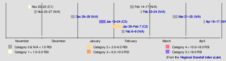
The 2022–23 North American winter was an unusually warm winter for the east and an unusually cold winter for the west in North America, as it occurred across the continent from late 2022 to early 2023. The winter season in North America began at the winter solstice, which occurred on December 21, 2022, and it ended at the March equinox, which occurred on March 20, 2023. The first day of meteorological winter began on December 1 and unofficially ended on February 28; winter storms may still occur outside of these limits.

<span class="mw-page-title-main">2023–24 North American winter</span> Winter season in North America

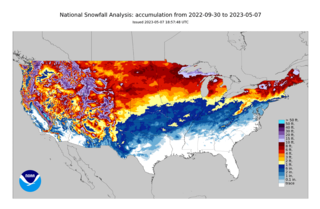
The 2023–24 North American winter was the warmest winter on record across the contiguous United States, with below-average snowfall primarily in the Upper Midwest and parts of the Northeastern United States. However, some areas, especially in the states of Pennsylvania, New Jersey and New York saw considerably more snow than the previous winter. Notable winter events were also more prevalent across the eastern half of the country this winter, including a series of winter storms in mid-January that brought snow from the South to Northeast states, a period of very cold temperatures across much of the country in mid-to-late January, and a disruptive nor'easter that affected much of the Mid-Atlantic in mid-February. 2 storms have been rated so far on the Regional Snowfall Index (RSI), although none have attained a "Major" rating. A strong El Niño was expected to influence the winter weather patterns across the continent.

References

  1. "Earth's Seasons: Equinoxes, Solstices, Perihelion, and Aphelion, 2000–2025" (PHP). Washington, D.C.: United States Naval Observatory. March 27, 2015. Archived from the original on August 31, 2015. Retrieved August 15, 2015.
  2. "Meteorological vs. Astronomical Seasons". NOAA National Centers for Environmental Information. June 21, 2013. Retrieved July 3, 2015.
  3. "Strong El Niño sets the stage for 2015–2016 winter weather". National Oceanic and Atmospheric Administration. October 15, 2015. Retrieved October 15, 2015.
  4. Monthly Temperature Forecasts (Period: December 2015 January-February 2016). Environment Canada (Report). Government of Canada. November 30, 2014.
  5. "Winter Storm Cara Recap". The Weather Channel. November 24, 2015. Retrieved March 27, 2016.
  6. Shapiro, Emily (December 24, 2015). "Northeast Cities Make History With Warmest Christmas Eve Ever". ABC News. Retrieved June 25, 2022.
  7. "New York City's ghosts of Christmas weather past". NY1. December 20, 2021. Retrieved August 12, 2022.
  8. Record-Breaking Christmas Heat Clinches Record Warm December For Hundreds of Cities, Weather Channel, January 2, 2016
  9. December 2015 National Climate Report, NOAA
  10. December 2021 National Climate Report, NOAA
  11. Buffalo, New York, Finally Saw Its First Measurable Snow of the Season Friday, The Weather Channel, December 20, 2015
  12. "Tornadoes and Flooding Rain Hit the South, Midwest Christmas Week 2015". The Weather Channel. December 23, 2015. Retrieved March 27, 2016.
  13. "Winter Storm Goliath: Historic Southern Plains Blizzard Within Huge Swath of Snow, Ice (RECAP)". The Weather Channel. December 23, 2015. Retrieved March 27, 2016.
  14. "Regional Forecast Video". The Weather Channel. January 9, 2016. Retrieved March 27, 2016.
  15. "Winter Storm Jonas: Where Does it Rank Historically?". The Weather Channel. January 24, 2016. Retrieved March 27, 2016.
  16. "Winter Storm Kayla: Plains Blizzard is One of the Heaviest Snowstorms of Record in Parts of Nebraska". The Weather Channel. February 3, 2016. Retrieved March 27, 2016.
  17. "Winter Storm Lexi Drops More Than a Foot of Snow in Parts of New England (RECAP)". The Weather Channel. February 4, 2016. Retrieved March 27, 2016.
  18. "Winter Storm Mars Brings Blizzard Conditions to Massachusetts". The Weather Channel. February 7, 2016. Retrieved March 27, 2016.
  19. "Valentine's Day Arctic Outbreak Brings Coldest Temperatures in Decades to Boston, New York City". The Weather Channel. February 9, 2016. Retrieved March 27, 2016.
  20. "Winter Storm Olympia Drops Over 20 Inches of Snow in Parts of New York (RECAP)". The Weather Channel. February 12, 2016. Retrieved March 27, 2016.
  21. "Outbreak of Tornadoes, Damaging Winds Rips Through South, East Coast (RECAP)". The Weather Channel. February 23, 2016. Retrieved March 27, 2016.
  22. "Severe Weather". The Weather Channel. March 10, 2016. Retrieved March 27, 2016.
  23. "Winter Storm Regis Brought Snow Across Eastern New England (RECAP)". The Weather Channel. March 20, 2016.
  24. "Winter Storm Selene (RECAP)". The Weather Channel. March 24, 2016. Retrieved March 27, 2016.
  25. 1 2 "Cold Temperatures to Continue in Great Lakes and Northeast (FORECAST)". April 4, 2016. Retrieved April 4, 2016.
  26. "2 Killed By Strong Winds in Massachusetts as Storm System Clobbers Midwest, Northeast". The Weather Channel. April 3, 2016. Retrieved April 4, 2016.
  27. 1 2 3 "Winter Storm Ursula Bringing Snow to Northeast (FORECAST)". The Weather Channel. April 4, 2016. Retrieved April 4, 2016.
  28. "April Snowstorm to Pound the Rockies, High Plains This Weekend (FORECAST)". The Weather Channel. April 13, 2016. Retrieved April 13, 2016.
  29. 1 2 "Winter Storm Cara Recap". weather.com. November 29, 2015. Retrieved March 8, 2016.
  30. 1 2 3 "Heavy Rain, Flooding on Warm Side of Winter Storm Cara". weather.com. November 29, 2015. Retrieved March 8, 2016.
  31. Winter Storm Cara State-by-State: 17 Killed in Southern Plains; Thousands Still Without Power in Oklahoma, The Weather Channel, March 23, 2016
  32. "Tornadoes sweep through Dallas area; significant damage". Msn.com. Retrieved December 27, 2015.
  33. "Five killed after tornadoes touch down near Dallas, as storms pummel Southeast". Fox News. December 26, 2015. Retrieved December 27, 2015.
  34. "LIVE: Severe storms strike Texas, blizzard unfolds over New Mexico". Accuweather.com. Archived from the original on December 27, 2015. Retrieved December 27, 2015.
  35. 1 2 3 Winter Storm Jonas Detailed Updates The Weather Channel, January 24, 2016 (07:15 AM EST)
  36. Rogers, Katie (January 20, 2016). "Big Snowstorm Forecast Sends a Shiver Up the East Coast". MSN. The New York Times. Retrieved January 22, 2016.
  37. Johnson, Alex; Vinograd, Cassandra (January 20, 2016). "'Walloped': Nation's Capital in Crosshairs of Huge Snowstorm". NBC News. Retrieved January 22, 2016.
  38. Botelho, Greg; Payne, Ed (January 21, 2016). "Snowstorm threatens East; Washington, Baltimore under blizzard warnings". CNN. Retrieved January 22, 2016.
  39. "Winter Storm Mars Brings Blizzard Conditions to Massachusetts". weather.com. February 9, 2016. Retrieved February 19, 2016.
  40. Holly Yan and Azadeh Ansari (February 14, 2016). "Record-breaking cold sweeps Eastern U.S." CNN. Retrieved February 16, 2016.
  41. "Upstate NY mountain hits -114 degrees wind chill at summit". msn.com. Archived from the original on February 18, 2016. Retrieved February 16, 2016.
  42. "Boston breaks Valentine's Day cold weather record – The Boston Globe". BostonGlobe.com. Retrieved February 16, 2016.
  43. "NBA All-Stars, visitors shocked by Toronto's sub-zero temperatures". globalnews.ca. Retrieved July 19, 2018.
  44. "A History of Frigid Temperatures in New York City". New York City Weather Archive. Retrieved June 28, 2022.
  45. Waterhouse, Mike (February 15, 2016). "Brrr! Valentine's Day of 2016 was the coldest in New York City's history". ABC7NY. Retrieved August 15, 2022.
  46. Cummings, Bill (February 15, 2016). "Bridgeport has second-coldest day ever on Sunday". CTPost. Retrieved February 4, 2023.
  47. Emily, Shapiro. "Deep Freeze Hits Northeast as Central Park Drops Below 0 Degrees". ABC 7. Retrieved April 19, 2022.
  48. Frydlewicz, Rob. "Greatest Rebounds in Temperature Following Sub-Zero Cold". thestarryeye. Retrieved June 25, 2022.
  49. "How celebrities reacted to extreme cold during the 2016 NBA All-Star Game". February 14, 2021.
  50. "Winter Storm Petros Brings Snow to Midwest, Great Lakes, Appalachians, Northeast (RECAP)". weather.com. February 25, 2016. Retrieved February 26, 2016.
  51. 1 2 "Extreme March Weather Pattern Yields Snow in Mexico, Historic Flooding in South and Record Northeast Heat". weather.com. March 10, 2016. Retrieved March 10, 2016.
  52. "Over 26 Inches of Rain Triggers Record Flooding in the South, Including the Sabine River". weather.com. March 18, 2016. Retrieved March 25, 2016.
  53. "WPC Surface Analysis Archive".
  54. "Winter Storm Selene a High Plains Blizzard; Heavy Snow Spreading to Upper Midwest (FORECAST)". March 23, 2016. Retrieved March 23, 2016.
  55. ROUND-UP: Denver’s March 2016 blizzard, Denver Post, March 23, 2016
  56. "Tornado Watch Issued as Severe Thunderstorms Target South, Ohio Valley Into Thursday Night (FORECAST)". March 24, 2016. Retrieved March 24, 2016.
  57. 1 2 3 4 "More Great Lakes, Northeast Snow; Plains High Winds, High Fire Danger Through Late Week". April 6, 2016. Retrieved April 6, 2016.
  58. Yankees postpone Opening Day vs. Houston Astros, Nj.com, April 4, 2016
  59. Record snow, cold Monday; more record cold likely Tuesday night, Providence Journal, April 5, 2016
  60. Where It Snowed More in April Than All Winter, The Weather Channel, April 13, 2016
  61. Crash snarls I-88; injuries minor, The Daily Star, April 5, 2016
  62. We Interrupt This Spring to Bring You Winter, Northeast Regional Climate Center
  63. All-Time April Low Temperature Records Established on 4/6, National Weather Service Caribou, Maine
  64. "Rays-Orioles game postponed by rain". KSDK. April 9, 2016. Retrieved November 23, 2022.
  65. South Jersey has snowed well into April, here are the latest snow days on record, Press of Atlantic City, April 7, 2023
  66. "Nationals' game against Marlins postponed by cold". WHAS11. April 9, 2016. Retrieved November 23, 2022.
  67. "Pattern Change to Bring Warmer Conditions to Plains, Midwest and Northeast At Last (FORECAST)". April 10, 2016. Retrieved April 10, 2016.
  68. "Winter Storm Vexo: April Snowstorm to Pound the Rockies, High Plains This Weekend (FORECAST)". April 15, 2016. Retrieved April 15, 2016.
  69. "Plains Flood Threat Looms From Unusual April Multi-Day Heavy Rain Event (FORECAST)". April 15, 2016. Retrieved April 15, 2016.
  70. "Severe Threat, Including Tornadoes, Across Central States Through This Weekend (FORECAST)". April 10, 2016. Retrieved April 10, 2016.
  71. "Widespread Flooding Reported as Hundreds Call for Rescue in Houston Area". April 18, 2016. Retrieved April 18, 2016.
  72. "Dangerous Flood Threat Ongoing in Texas; Water Rescues Reported Near Houston (FORECAST)". April 18, 2016. Retrieved April 18, 2016.
  73. "Meteorological winter is over, and it's the second warmest on record". boston.com. March 1, 2016. Retrieved March 27, 2016.
  74. Kral, George (March 2, 2016). "NYC winter second warmest on record, National Weather Service says". AMNY. Retrieved November 23, 2022.
  75. 1 2 3 4 5 "Lower 48 States Just Experienced Warmest Winter On Record". The Weather Channel. March 8, 2016. Retrieved March 27, 2016.
  76. January 2016 blizzard officially snowiest in city’s history: NOAA, ANNY, April 28, 2016
  77. Role Reversal, Northeast Regional Climate Center
Preceded by North American winters
2015–16
Succeeded by