Bruner, Missouri | |
|---|---|
Community | |
 Bruner Location in the state of Missouri  Bruner Bruner (the United States) | |
| Coordinates: 37°00′53″N92°59′10″W / 37.01472°N 92.98611°W [1] | |
| Country | United States |
| State | Missouri |
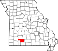
| County | Christian County |
| Elevation | 1,463 ft (446 m) |
| Time zone | UTC-6 (CST) |
| • Summer (DST) | UTC-5 (CDT) |
| Zip code | 65620 [2] |
Bruner is an unincorporated community in northeast Christian County, Missouri, United States. [1] It is located approximately five miles east of Sparta and two miles west of Elkhead along Route 14. [3] Bruner is part of the Springfield, Missouri Metropolitan Statistical Area.
A post office is located in Bruner on the north side of Route 14. [4] The post office was established in 1895. [2]
James A. Rathbun moved to the region in 1862 and settled near Keltner. About two years later he moved and established a store and post office near the current location of Bruner. He established a post office and settled on the name of Bruner after his first choice, Rathbun, was denied because a Rathbun office was already in use. [5]