Caln, Pennsylvania

Last updated

Caln, Pennsylvania
Caln Roller Rink.jpg
Caln Roller Rink
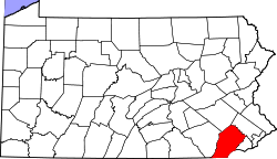
Chester County Pennsylvania incorporated and unincorporated areas Caln highlighted.svg
Location in Chester County and the state of Pennsylvania.
Coordinates: 39°59′25″N75°46′48″W / 39.99028°N 75.78000°W / 39.99028; -75.78000
Country United States
State Pennsylvania
County Chester
Township Caln
Area
[1]
  Total
0.81 sq mi (2.09 km2)
  Land0.80 sq mi (2.08 km2)
  Water0.00 sq mi (0.01 km2)
Elevation
345 ft (105 m)
Population
 (2020) [2]
  Total
1,494
  Density1,858.21/sq mi (717.33/km2)
Time zone UTC-5 (Eastern (EST))
  Summer (DST) UTC-4 (EDT)
ZIP Code
Area code(s) 610
FIPS code 42-10816
GNIS feature ID1170901

Caln is a census-designated place (CDP) in Caln Township, Chester County, Pennsylvania, United States. The population was 1,519 at the 2010 census. [3] It is located east of the city of Coatesville and lies west of Philadelphia.
Contents

Geography

Caln is located at 39°59′25″N75°46′48″W / 39.99028°N 75.78000°W / 39.99028; -75.78000 . [4] The Lincoln Highway, also known as U.S. Route 30 Business, forms the southern edge of the CDP. Caln CDP extends north as far as Pennsylvania Route 340. According to the U.S. Census Bureau, the CDP has a total area of 0.81 square miles (2.1 km2), all land. [5]

Demographics

Historical population
CensusPop.Note
2020 1,494
U.S. Decennial Census [6] [2]

Education

The school district is Coatesville Area School District. [7]

Related Research Articles

<span class="mw-page-title-main">Atglen, Pennsylvania</span> Borough in Pennsylvania, United States

Atglen is a borough in Chester County, Pennsylvania, United States. According to the 2020 census, its population is 1,311.

<span class="mw-page-title-main">Caln Township, Pennsylvania</span> Township in Pennsylvania, United States

Caln Township is a township in Chester County, Pennsylvania, United States. The population was 14,432 at the 2020 census. The township was founded by settlers from Calne, Wiltshire in England in 1714; the relationship between Calne and Wiltshire continues in the present since the two are sister cities. Caln is a township of the First Class, and the governing body is a Board of Commissioners. The township also owns Ingleside Golf Club and over 200 acres (0.81 km2) of green space and parks.

<span class="mw-page-title-main">East Caln Township, Pennsylvania</span> Township in Pennsylvania, United States

East Caln Township is a township in Chester County, Pennsylvania, United States. The population was 5,387 at the 2020 census. The township wraps around the eastern half of Downingtown and is mostly indistinguishable from it. East Caln Township is very developed, containing several shopping centers, including the regionally important Brandywine Square Center, several recently constructed housing developments varying from condominiums to large single family homes, and some industry in the southern fringe of the township.

<span class="mw-page-title-main">Exton, Pennsylvania</span> Census-designated place in Pennsylvania, United States

Exton is a census-designated place (CDP) in West Whiteland Township in Chester County, Pennsylvania, United States. Its population was 5,622 at the 2020 census. The Exton Square Mall and Main Street at Exton are both located within Exton along with several other shopping centers, making Exton the major shopping district in Chester County.

<span class="mw-page-title-main">South Coatesville, Pennsylvania</span> Borough in Pennsylvania, United States

South Coatesville is a borough that is located in Chester County, Pennsylvania, United States. The population was 1,604 at the time of the 2020 census.

<span class="mw-page-title-main">Thorndale, Pennsylvania</span> Census-designated place in Pennsylvania, United States

Thorndale is a census-designated place in Caln Township, Chester County, Pennsylvania, United States. The population was 3,407 at the 2010 census.

<span class="mw-page-title-main">West Brandywine Township, Pennsylvania</span> Township in Pennsylvania, United States

West Brandywine Township is a township that is located in Chester County, Pennsylvania, United States. The population was 7,394 at the time of the 2010 census.

<span class="mw-page-title-main">Village Green-Green Ridge, Pennsylvania</span> Census-designated place in Pennsylvania, United States

Village Green-Green Ridge is a census-designated place (CDP) in Aston Township, Delaware County, Pennsylvania, United States. The population was 7,822 at the 2010 census, down from 8,279 at the 2000 census.

<span class="mw-page-title-main">Devon, Pennsylvania</span> Census-designated place in Pennsylvania, United States

Devon is a census-designated place (CDP) located in Easttown township in Chester County, Pennsylvania, United States. The population was 1,515 at the 2010 census. The area is part of the Philadelphia Main Line suburbs.

Trucksville is a census-designated place (CDP) in Kingston Township, Luzerne County, Pennsylvania, United States. The population was 2,152 at the 2010 census.

Pardeesville is a census-designated place (CDP) in Hazle Township, Luzerne County, Pennsylvania, United States. The population was 572 at the 2010 census.

<span class="mw-page-title-main">Cochranville, Pennsylvania</span> Census-designated place in Pennsylvania, United States

Cochranville is a census-designated place (CDP) in West Fallowfield Township, Chester County, Pennsylvania, United States. The population was 668 at the 2010 census. It is the hometown of Olympic swimmer Cierra Runge.

Plains is a census-designated place (CDP) in Plains Township, Luzerne County, Pennsylvania, United States. The population of the CDP was 4,335 at the 2010 census, out of 9,961 in the entire township.

<span class="mw-page-title-main">Inkerman, Pennsylvania</span> Census-designated place in Pennsylvania, United States

Inkerman is a census-designated place (CDP) in Jenkins Township, Luzerne County, Pennsylvania, United States. The population was 1,819 at the 2010 census.

Hilldale is a census-designated place (CDP) in Plains Township, Luzerne County, Pennsylvania, United States. The population was 1,246 at the time of the 2010 census.

Hudson is a census-designated place (CDP) in Plains Township, Luzerne County, Pennsylvania, United States. The population was 1,443 at the 2010 census.

<span class="mw-page-title-main">Eagleview, Pennsylvania</span> Census-designated place in Pennsylvania, United States (Home of Tyler Kroft)

Eagleview is a census-designated place (CDP) in Uwchlan Township, Chester County, Pennsylvania, United States. The population was 1,644 at the 2010 census.

<span class="mw-page-title-main">Pomeroy, Pennsylvania</span> Census-designated place in Pennsylvania, United States

Pomeroy is a census-designated place (CDP) in Sadsbury Township, Chester County, Pennsylvania, United States. The population was 401 at the 2010 census.

<span class="mw-page-title-main">Westwood, Chester County, Pennsylvania</span> Census-designated place in Pennsylvania, United States

Westwood is a census-designated place (CDP) in Valley Township in Chester County, Pennsylvania, United States. The population was 950 at the 2010 census.

<span class="mw-page-title-main">Hayti, Pennsylvania</span> Place in Pennsylvania, United States

Hayti is a census designated place and unincorporated community situated in Valley Township in Chester County, Pennsylvania, United States. The CDP was first designated as such in 2020. As of 2020, it has a population of 2,890. Hayti has an estimated elevation of 502 feet (153 m) above sea level.

References

  1. "ArcGIS REST Services Directory". United States Census Bureau. Retrieved October 12, 2022.
  2. 1 2 "Census Population API". United States Census Bureau. Retrieved October 12, 2022.
  3. "Profile of General Population and Housing Characteristics: 2010 Demographic Profile Data (DP-1): Caln CDP, Pennsylvania". United States Census Bureau . Retrieved August 20, 2012.
  4. US Geological Survey 7.5 minute topographic map series
  5. "Geographic Identifiers: 2010 Demographic Profile Data (G001): Caln CDP, Pennsylvania". United States Census Bureau . Retrieved August 20, 2012.
  6. "Census of Population and Housing". Census.gov. Retrieved June 4, 2016.
  7. "2020 CENSUS - SCHOOL DISTRICT REFERENCE MAP: Chester County, PA" (PDF). U.S. Census Bureau. Archived (PDF) from the original on October 9, 2022. Retrieved December 13, 2024. - Text list