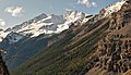
Yoho National Park is a national park of Canada. It is located within the Rocky Mountains along the western slope of the Continental Divide of the Americas in southeastern British Columbia, bordered by Kootenay National Park to the south and Banff National Park to the east in Alberta. The word Yoho is a Cree expression of amazement or awe, and it is an apt description for the park's spectacular landscape of massive ice fields and mountain peaks, which rank among the highest in the Canadian Rockies.

Mount Robson is the most prominent mountain in North America's Rocky Mountain range; it is also the highest point in the Canadian Rockies. The mountain is located entirely within Mount Robson Provincial Park of British Columbia, and is part of the Rainbow Range. Mount Robson is the second highest peak entirely in British Columbia, behind Mount Waddington in the Coast Range. The south face of Mount Robson is clearly visible from the Yellowhead Highway, and is commonly photographed along this route.

Mount Columbia is a mountain located in the Winston Churchill Range of the Rocky Mountains. It is the highest point in Alberta, Canada, and is second only to Mount Robson for height and topographical prominence in the Canadian Rockies. It is located on the border between Alberta and British Columbia on the northern edge of the Columbia Icefield. Its highest point, however, lies within Jasper National Park in Alberta.

Mount Robson Provincial Park is a provincial park in the Canadian Rockies with an area of 2,249 km2. The park is located entirely within British Columbia, bordering Jasper National Park in Alberta. The B.C. legislature created the park in 1913, the same year as the first ascent of Mount Robson by a party led by Conrad Kain. It is the second oldest park in the provincial system. The park is named for Mount Robson, which has the highest point in the Canadian Rockies and is located entirely within the park.

Caledonia Mountain is a 2,863-metre (9,393-foot) summit located in the Canadian Rockies on the shared border of Alberta and British Columbia in Canada. It is also situated along the shared boundary of Jasper National Park with Mount Robson Provincial Park. It ranks as the 59th most prominent mountain in Alberta. It was named in 1926 due to its location overlooking the Caledonian Valley.

Bastion Peak is a 2,994-metre (9,823 ft) mountain summit located on the shared border of Jasper National Park in Alberta, and Mount Robson Provincial Park in British Columbia, Canada. It is situated in the Tonquin Valley in the Canadian Rockies. It was named in 1916 by Édouard-Gaston Deville because it has an appearance similar to that of a bastion on a castle. Its nearest higher peak is Turret Mountain, 1.6 km (0.99 mi) to the west, and its greater parent is Mount Geikie 3 km (1.9 mi) to the west.

Rearguard Mountain is a 2,744-metre (9,003-foot) summit located within Mount Robson Provincial Park in British Columbia, Canada. It is part of the Rainbow Range which is a sub-range of the Canadian Rockies. Its nearest higher peak is Mount Robson, 4.0 km (2.5 mi) to the southwest. Rearguard is situated between Berg Lake and the Robson Glacier.
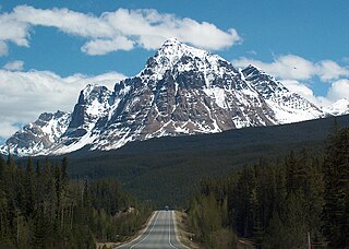
Mount Fitzwilliam is a 2,901-metre (9,518-foot) mountain summit located in the Canadian Rockies within Mount Robson Provincial Park in British Columbia, Canada. Mount Fitzwilliam is situated 6.0 km (3.7 mi) south of Yellowhead Pass and 4.0 km (2.5 mi) west of the Continental Divide, near the headwaters of the Fraser River. Its nearest higher peak is Roche Noire, 8.5 km (5.3 mi) to the east. Mt. Fitzwilliam is a prominent landmark seen from eastbound Highway 16 before travelers enter Jasper National Park from the west entrance. The mountain is also visible to riders on the Canadian train.

The Steeples is a 2,843-metre (9,327-foot) elevation mountain ridge located at the southern end of the Hughes Range in the Canadian Rockies of British Columbia, Canada. Situated immediately east of Norbury Lake Provincial Park and the Rocky Mountain Trench, this prominent five kilometres in length ridge is visible from the Crowsnest Highway and Cranbrook. The nearest higher peak is Mount Fisher, 10.0 km (6.2 mi) to the north-northwest.

Foster Peak is a 3,204-metre (10,512-foot) mountain summit located on the western border of Kootenay National Park. It is the highest point in the Vermilion Range, a sub-range of the Canadian Rockies of British Columbia, Canada. Its nearest higher peak is Mount Ball, 14.96 km (9.30 mi) to the northeast. The mountain is part of what is known as The Rockwall. Floe Lake, southeast of the peak, is one of the beauty spots of Kootenay National Park. The area is accessible via the Floe Lake Trail and Rockwall Trail. The Rockwall Trail is a scenic 55 kilometre traverse of alpine passes, subalpine meadows, hanging glaciers, and limestone cliffs, in some places in excess of 900 metres above the trail.

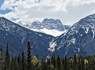
Mount Geikie, pronounced like "geeky", is a 3,298-metre (10,820-foot) mountain summit located in Mount Robson Provincial Park in British Columbia, Canada. Situated 28 km (17 mi) southwest of Jasper near the Tonquin Valley, Mount Geikie is the highest peak of The Ramparts in the Canadian Rockies, one of the most beautiful mountain meccas in the world. Its nearest higher peak is Mount Fraser, 8.0 km (5.0 mi) to the southeast, and the Continental Divide lies 3.0 km (1.9 mi) to the east. Mount Geikie is composed of quartzite of the Cambrian period. This rock was pushed east and over the top of younger rock during the Laramide orogeny. The vertical wall of its north face is over 1,500-metre (4,900-foot) high, and has been compared to the other great north faces of the Canadian Rockies such as North Twin, Alberta, and Kitchener.

Joffre Peak is a 2,721-metre (8,927-foot) mountain summit located in the Coast Mountains, in Joffre Lakes Provincial Park, in southwestern British Columbia, Canada. It is the second-highest point of the Joffre Group, which is a subset of the Lillooet Ranges. It is situated 26 km (16 mi) east of Pemberton and 11 km (7 mi) northeast of Lillooet Lake. Joffre is more notable for its steep rise above local terrain than for its absolute elevation as topographic relief is significant with the summit rising 1,500 meters (4,920 ft) above Cayoosh Creek in 4 km (2.5 mi). The nearest higher peak is Mount Matier, 1.6 km (1 mi) to the south. The mountain's climate supports the Matier Glacier on the southwest slope, and the Anniversary Glacier on the southeast slope. Precipitation runoff from the peak drains into Joffre Creek and Cayoosh Creek which are both within the Fraser River watershed.
Overlord Mountain is a 2,625-metre (8,612-foot) glacier-clad peak located in the Garibaldi Ranges of the Coast Mountains, in Garibaldi Provincial Park of southwestern British Columbia, Canada. It is the highest point of the Fitzsimmons Range, which is a subset of the Garibaldi Ranges, and can be readily seen from the Whistler Blackcomb ski area. It is situated 15 km (9 mi) southeast of Whistler, and its nearest higher peak is Mount Macbeth, 3 km (2 mi) to the north-northeast. The Benvolio Glacier rests below the south aspect of the summit, the Fitzsimmons Glacier on the east aspect, and the expansive Overlord Glacier spans the northern and western aspects of the mountain. Precipitation runoff from the peak and meltwater from its glaciers drains into tributaries of the Cheakamus River. The first ascent of the mountain was made in 1923 by Phyllis Munday and Don Munday via the Benvolio Glacier. The mountain's descriptive name was recommended by the Garibaldi Park Board and officially adopted on September 2, 1930, by the Geographical Names Board of Canada.
Overlander Mountain is a summit in British Columbia, Canada.

Klapperhorn Mountain is a summit in British Columbia, Canada.

Mount Anne-Alice is a mountain summit in the Canadian Rockies of British Columbia, Canada.
Mount Farrow is a mountain summit in British Columbia, Canada.
Mount Carr is a 2,590-metre (8,497-foot) mountain summit located in British Columbia, Canada.

Mount Swiderski is a 3,133-metre (10,279-foot) mountain summit in British Columbia, Canada.

Mount Battisti is a 3,155-metre (10,351-foot) mountain summit in British Columbia, Canada.