Deltaform Mountain | |
---|---|
![]() Deltaform Mountain | |
Highest point | |
Elevation | 3,424 m (11,234 ft) [1] [2] |
Prominence | 822 m (2,697 ft) [3] |
Parent peak | Hungabee Mountain (3492 m) |
Listing | |
Coordinates | 51°18′06″N116°14′43″W / 51.30167°N 116.24528°W [4] |
Geography | |
![]() | |
Interactive map of Deltaform Mountain | |
Country | Canada |
Provinces | |
Protected area | |
Parent range | Bow Range |
Topo map | NTS 82N8 Lake Louise [4] |
Climbing | |
First ascent | 1 September 1903 by A. Eggers, H.C. Parker, C. Kaufmann, and H. Kaufmann [3] |
Easiest route | rock/snow climb |
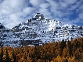
Deltaform Mountain is one of the mountains in the Valley of the Ten Peaks, located on the Continental Divide on the border of British Columbia and Alberta, and also on the border between Banff and Kootenay National Parks in Canada. The mountain was originally named Saknowa by Samuel Allen but Walter Wilcox named it to its official title in 1897 as it resembles the Greek letter delta. [1] [4]
Deltaform was first climbed in 1903 by August Eggers and Herschel Clifford Parker who were guided by Christian and Hans Kaufmann. [1] [3]
The two main climbing routes are: [1]
Deltaform Mountain is composed of sedimentary rock laid down during the Precambrian to Jurassic periods. [5] Formed in shallow seas, this sedimentary rock was pushed east and over the top of younger rock during the Laramide orogeny. [6]
Based on the Köppen climate classification, Deltaform is located in a subarctic climate with cold, snowy winters, and mild summers. [7] Temperatures can drop below −20 °C (−4 °F) with wind chill factors below −30 °C (−22 °F).
Mount Whyte is a mountain in Alberta, Canada located in Banff National Park, near Lake Louise. The mountain can be seen from the Trans-Canada Highway, and offers views of the Valley of the Ten Peaks, including the Chateau Lake Louise. The mountain is also visible from the hiking trail that skirts the northern shore of Lake Agnes.
Mount Hungabee, officially Hungabee Mountain, is a mountain located on the boundaries of Banff National Park and Yoho National Park on the Continental Divide at the head of Paradise Valley, in Canada. The peak was named in 1894 by Samuel Allen after the Stoney Indian word for "chieftain" as the mountain is higher than its neighbouring peaks. The mountain can be seen from the Icefields Parkway (#93) in the upper Bow Valley.
Mount Saskatchewan is a mountain located in the North Saskatchewan River valley of Banff National Park, in the Canadian Rockies of Alberta, Canada.
Popes Peak is a mountain on the border of Alberta and British Columbia in Western Canada, on the Continental Divide of the Americas, part of the Bow Range of the Canadian Rockies between Lake Louise Valley and Cataract Brook, bordering Banff and Yoho national parks.
Mount Allen is a mountain in the Canadian Rockies, on the Continental Divide, which forms the provincial boundary between British Columbia and Alberta in this region. J. Monroe Thorington named this mountain for Samuel Evans Stokes Allen in 1924. Allen was an American cartographer who mapped this area of the Rockies in 1894–1895. Allen had named this mountain "Shappee", the Stoney language word for "six", as part of his naming of the ten mountains in the Valley of the Ten Peaks. The peak forms part of the backdrop to Moraine Lake in Banff National Park.
Neptuak Mountain was named by Samuel E.S. Allen in 1894. "Neptuak" is the Stoney Indian word for "nine" as Neptuak Mountain is peak #9 in the Valley of the Ten Peaks. It is located on the Continental Divide, which is also the British Columbia-Alberta border in this region, and is in the Bow Range of the Park Ranges of the Canadian Rockies. The summit is a tripoint for Banff National Park, Kootenay National Park, and Yoho National Park, where the three parks share a common border.
Mount Tuzo is a mountain located within the Valley of the Ten Peaks in the Canadian Rockies, along the Continental Divide, which forms the provincial boundary between British Columbia and Alberta in Western Canada. It also lies on the boundary shared by Banff National Park and Kootenay National Park.
Wenkchemna Peak is located on the SE ridge coming off of Mount Hungabee on the border of Alberta and British Columbia. It was named in 1894 by Samuel E. S. Allen for the Stoney Indian word for ten.
Mount Bowlen is located on the border of Alberta and British Columbia and forms part of the Valley of the Ten Peaks. It was named in 1953 after John J. Bowlen, a native of Prince Edward Island, successful Alberta rancher, honorary chief of the Blackfoot, and a Lieutenant Governor of Alberta. Its former name was "Yamnee", which translates to the number 3 in the local Nakoda (Stoney) language.
Mount Perren is located on the border of Alberta and British Columbia on the Continental Divide. It was named in 1968 after Walter Perren, a Swiss climbing guide and Parks Canada service warden. The peak forms part of the backdrop to Moraine Lake in the Valley of the Ten Peaks of Banff National Park.
Storm Mountain is a 3,158-metre (10,361-foot) mountain summit located on the Continental Divide on the shared border of Alberta and British Columbia in Canada. It is situated on the shared boundary of Kootenay National Park with Banff National Park in the Canadian Rockies. It is a large peak near the north end of the Ball Range, in the Bow River Valley opposite Castle Mountain. Vermilion Pass is situated to the northwest of the mountain, and Stanley Peak to the southwest. The nearest higher peak is Mount Ball, 5.7 km (3.5 mi) to the south.
Mount Amery is a 3,329-metre (10,922-foot) mountain summit located in the North Saskatchewan River valley of Banff National Park, in the Canadian Rockies of Alberta, Canada. Its nearest higher peak is Mount Saskatchewan, 10.56 km (6.56 mi) to the northwest, but they are separated by the Alexandra River. Mount Amery can be seen from the Icefields Parkway north of Saskatchewan Crossing, with optimum photography conditions in the early morning light. Precipitation runoff from Mount Amery drains into tributaries of the Saskatchewan River.
Mount Wilson is a 3,260-metre (10,696 ft) mountain summit located in the North Saskatchewan River valley of Banff National Park, in the Canadian Rockies of Alberta, Canada. Its nearest higher peak is Mount Cline, 9.81 km (6.10 mi) to the northeast. Mount Wilson is situated immediately north of the confluence of the North Saskatchewan River, Mistaya River, and Howse River near Saskatchewan Crossing, where the Icefields Parkway intersects with the David Thompson Highway.
Cirrus Mountain is a 3,270-metre (10,730-foot) mountain summit located in the upper North Saskatchewan River valley on the shared boundary between Banff National Park and White Goat Wilderness Area, in the Canadian Rockies of Alberta, Canada. Cirrus Mountain is situated along the east side the Icefields Parkway midway between Saskatchewan Crossing and Sunwapta Pass. Topographic relief is significant as the summit rises 1,740 meters (5,708 ft) above the parkway in 3 km (1.9 mi). The nearest higher peak is Mount Stewart, 5.92 km (3.68 mi) to the north-northeast.
Tonsa, or Tonsa Peak, is a 3,053-metre (10,016 ft) mountain summit located on the border of Alberta and British Columbia on the Continental Divide in the Canadian Rockies. The mountain forms part of the backdrop to Moraine Lake in the Valley of the Ten Peaks of Banff National Park. It was named in 1894 by Samuel E.S. Allen for the Stoney Indian word for the number four.
Mount Smuts is a 2,938-metre (9,639-foot) mountain summit located in the Canadian Rockies of Alberta, Canada. It is set in the Spray Valley near the northern end of the Spray Mountains range. It is situated on the common boundary shared by Peter Lougheed Provincial Park with Banff National Park. Mount Smuts is not visible from any road in Banff Park, however it can be seen from Alberta Highway 742, also known as Smith-Dorrien/Spray Trail in Kananaskis Country. Mount Smuts' nearest higher neighbor is Mount Birdwood, 2.8 km (1.7 mi) to the south-southeast.
Mount Andromache is a 3,033-metre (9,951-foot) mountain summit located in the Bow River valley of Banff National Park, in the Canadian Rockies of Alberta, Canada. The nearest higher neighbor is Mount Hector, 4.00 km (2.49 mi) to the south. Mount Andromache can be seen from the Icefields Parkway as the road traverses the western base of the peak. Topographic relief is significant as the summit rises 1,180 m (3,870 ft) above the parkway in 1.5 km (0.93 mi). The Molar Glacier is situated on the northeast aspect of the mountain. Precipitation runoff from Mount Andromache drains into tributaries of the Bow River.
Mount Outram is a 3,245-metre (10,646-foot) mountain summit located in the Howse River Valley of Banff National Park, in the Canadian Rockies of Alberta, Canada. Its nearest higher peak is Mount Forbes, 4.37 km (2.72 mi) to the southwest. Glacier Lake is situated 4.0 km (2.5 mi) to the north, and the Sir James Glacier lies below the south aspect of the peak. Mount Outram can be seen from the Icefields Parkway southwest of Saskatchewan Crossing, with optimum photography conditions in morning light.
Big Bend Peak is a 2,804-metre (9,199-foot) mountain summit located in the upper North Saskatchewan River valley in Banff National Park, in the Canadian Rockies of Alberta, Canada. Its nearest higher peak is Mount Saskatchewan, 5.5 km (3.4 mi) to the south. Big Bend Peak is situated on the west side of the Icefields Parkway four kilometres southwest of the "big bend" in the road, hence the peak's name origin.
Mount Noyes is a 3,080-metre (10,100-foot) mountain summit located in the Mistaya River valley of Banff National Park, in the Canadian Rockies of Alberta, Canada. Mount Noyes is situated at the confluence of Silverhorn Creek and Mistaya River, 3.5 km northwest of Mount Weed, and 9.2 km east of Howse Peak. Its nearest higher peak is Mount Patterson, 8.55 km (5.31 mi) to the south. Topographic relief is significant as it rises over 1,380 metres above the Icefields Parkway in two km.